Monti Sabatini
Mountain range in Italy
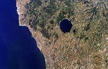
The Monti Sabatini is a geologic region in Lazio, central Italy, a remnant of intense volcanism which started ca. 600,000 years ago, mainly with pyroclastic and maar forming eruptions which continued until 100,000 years ago. The region is classified as a dormant volcanic district.[1] The mountains are part of the Lazio's Anti-Apennines. Included between the Monti Sabatini is the Lake Bracciano, which is a volcanotectonic depression formed about 3.7 Ma, and the Lake Martignano. The sedimentary base of the Sabatini complex lies buried under 200 m (660 ft) of volcanic ash and rocks.
Background

The highest point is Monte Rocca Romana (a postcaldera stratocone), at 612 m (2,008 ft).[citation needed]
Other mountains in the area include Monti della Tolfa, Monte Soratte, and more southwards, by the Monti Cornicolani.[citation needed]
See also
- List of volcanoes in Italy
- Monti Volsini
- Monti Cimini
References
- ^ Marra, F.; Castellano, C.; Cucci, L.; Florindo, F.; Gaeta, M.; Jicha, B. R.; Palladino, D. M.; Sottili, G.; Tertulliani, A.; Tomolei, C. (26 May 2020). "Monti Sabatini and Colli Albani: the dormant twin volcanoes at the gates of Rome". Scientific Reports. 10 (1): 8666. Bibcode:2020NatSR..10.8666M. doi:10.1038/s41598-020-65394-2. PMC 7251092. PMID 32457380.
External links
- Sabatini Volcanic Complex.
- Sabatini, Italy
- "Sabatini Complex". Global Volcanism Program. Smithsonian Institution. Retrieved 25 June 2021.
- v
- t
- e


- Latins
- Latium
- Ancient Rome
- Papal States
- Roman Republic (18th century)
- Roman Republic (19th century)
- Seven hills of Rome
- Alban Hills
- Aurunci Mountains
- Monti Ausoni
- Monte Cavo
- Cimini Hills
- Monti Ernici
- Monte Gorzano
- Monti della Laga
- Monti Lepini
- Monti della Meta
- Monte Petrella
- Monti Prenestini
- Monti Sabatini
- Monti Sabini
- Monte Soratte
- Monte Terminillo
- Monti della Tolfa
- Monti Volsini
- Monte Cassino
- Monte Abate
- Monte Altino
- Monte Appiolo
- Maschio dell'Ariano
- Maschio di Lariano
- Monte Artemisio
- Monte Autore
- Monte Carbonaro
- Monte Cefalo
- Cima del Redentore (monti Aurunci)
- Circeo
- Monte Crispi
- Monte Dragone
- Monte Faggeto
- Monte Fammera
- Mont Fogliano
- Monte Fusco
- Monte Guadagnolo
- Monte Lauro in Gaeta
- Monte Lauzo
- Le Rave Fosche
- Monte Livata
- Mainarde
- Maschio delle Faete
- Meta (monte)
- Monna
- Monte Caira
- Monte Cervello
- Monte Revole
- Monte Sorgenze
- Monte Trina
- Monte Val de' Varri – Monte Faito – Monte San Nicola
- Monte di Cambio
- Monte le Pezze
- Parco regionale urbano Monte Orlando
- Monte Orso
- Monte Pizzuto
- Monte Ruazzo
Categories
42°10′N 12°15′E / 42.167°N 12.250°E / 42.167; 12.250
Authority control databases | |
|---|---|
| International |
|
| National |
|
| Other |
|


