Meta Department
Department of Colombia
You can help expand this article with text translated from the corresponding article in Spanish. (October 2019) Click [show] for important translation instructions.
- Machine translation, like DeepL or Google Translate, is a useful starting point for translations, but translators must revise errors as necessary and confirm that the translation is accurate, rather than simply copy-pasting machine-translated text into the English Wikipedia.
- Consider adding a topic to this template: there are already 951 articles in the main category, and specifying
|topic=will aid in categorization. - Do not translate text that appears unreliable or low-quality. If possible, verify the text with references provided in the foreign-language article.
- You must provide copyright attribution in the edit summary accompanying your translation by providing an interlanguage link to the source of your translation. A model attribution edit summary is
Content in this edit is translated from the existing Spanish Wikipedia article at [[:es:Meta (Colombia)]]; see its history for attribution. - You may also add the template
{{Translated|es|Meta (Colombia)}}to the talk page. - For more guidance, see Wikipedia:Translation.
Department in Orinoquía Region, Colombia
Department of Meta Departamento del Meta | |
|---|---|
Department | |
 | |
 Flag  Coat of arms | |
| Motto: Llano Grande de Colombia y Meta | |
| Anthem: Himno de Meta (Colombia) | |
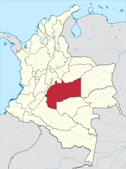 Meta shown in red | |
 Topography of the department | |
| Coordinates: high · 6th of 33 | |
| Website | www.meta.gov.co |
| Year | Pop. | ±% |
|---|---|---|
| 1973 | 242,664 | — |
| 1985 | 474,046 | +95.4% |
| 1993 | 618,427 | +30.5% |
| 2005 | 783,168 | +26.6% |
| 2018 | 1,039,722 | +32.8% |
| Source:[4] | ||
Meta (Spanish pronunciation: [ˈmeta]) is a department of Colombia. It is close to the geographic center of the country, to the east of the Andean mountains. A large portion of the department, which is also crossed by the Meta River, is covered by a grassland plain known as the Llanos. Its capital is Villavicencio. The department has a monument placed in the very geographic centre of Colombia, at a place known as Alto de Menegua, a few kilometers from Puerto López.
Achagua, which is similar to Piapoco, is an Indigenous language spoken by a minority in the department.
Municipalities
| Ariari | Villavicencio | Piedemonte | Meta River |
|---|---|---|---|
 |  | 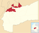 |  |
| El Castillo • El Dorado • Fuente de Oro • Granada • La Uribe • Lejanías • Mapiripán • Mesetas • Puerto Concordia • Puerto Lleras • Puerto Rico • San Juan de Arama • Vista Hermosa | Villavicencio | Acacías • Barranca de Upía • Castilla la Nueva • Cubarral • Cumaral • El Calvario • Guamal • Restrepo • San Carlos de Guaroa • San Juanito • San Martín | Cabuyaro • La Macarena • Puerto Gaitán • Puerto López |
See also
- Juan Manuel González Torres
- San Martín Territory
 Colombia portal

References
- ^ "DANE". Archived from the original on November 13, 2009. Retrieved February 13, 2013.
- ^ "Producto Interno Bruto por departamento", www.dane.gov.co
- ^ "Sub-national HDI - Area Database - Global Data Lab". hdi.globaldatalab.org. Retrieved 2018-09-13.
- ^ "Reloj de Población". DANE. Departamento Administrativo Nacional de Estadísitica. Archived from the original on 28 October 2016. Retrieved 6 July 2017.
External links
- Folklore llanero
- Government Meta
- Territorial-Environmental Information System of Colombian Amazon SIAT-AC website
- v
- t
- e


Authority control databases | |
|---|---|
| International |
|
| National |
|
| Geographic |
|
| Other |
|


