Martonvásár District
Districts of Hungary in Fejér
Martonvásár District Martonvásári járás | |
|---|---|
Districts of Hungary | |
 Coat of arms | |
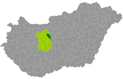 Martonvásár District within Hungary and Fejér County. | |
| Coordinates: 47°19′N 18°47′E / 47.31°N 18.79°E / 47.31; 18.79 | |
| Country |  Hungary Hungary |
| County | Fejér |
| District seat | Martonvásár |
| Area | |
| • Total | 277.13 km2 (107.00 sq mi) |
| • Rank | 8th in Fejér |
| Population (2011 census) | |
| • Total | 28,040 |
| • Rank | 7th in Fejér |
| • Density | 101/km2 (260/sq mi) |
Martonvásár (Hungarian: Martonvásári járás) is a district in eastern part of Fejér County. Martonvásár is also the name of the town where the district seat is found. The district is located in the Central Transdanubia Statistical Region.
Geography
Martonvásár District borders with Bicske District to the north, Érd District and Ráckeve District (Pest County) to the east, Dunaújváros District to the south, Gárdony District to the west. The number of the inhabited places in Martonvásár District is 8.
Municipalities
The district has 2 towns and 6 villages. (ordered by population, as of 1 January 2012)[1]
- Baracska (2,766)
- Ercsi (7,999)
- Gyúró (1,254)
- Kajászó (1,055)
- Martonvásár (5,811) – district seat
- Ráckeresztúr (3,311)
- Tordas (2,123)
- Vál (2,521)
The bolded municipalities are cities.
See also
References
- ^ A KSH 2012. évi helységnévkönyve
External links
- Postal codes of the Martonvásár District

| Authority control databases |
|
|---|
 | This Fejér location article is a stub. You can help Wikipedia by expanding it. |
- v
- t
- e


