Long Jetty, New South Wales
Suburb of Central Coast, New South Wales, Australia
| Long Jetty Central Coast, New South Wales | |||||||||||||||
|---|---|---|---|---|---|---|---|---|---|---|---|---|---|---|---|
 | |||||||||||||||
 | |||||||||||||||
| Population | 6,736 (SAL 2021)[1] | ||||||||||||||
| Postcode(s) | 2261 | ||||||||||||||
| Elevation | 2 m (7 ft) | ||||||||||||||
| Area | 2.4 km2 (0.9 sq mi) | ||||||||||||||
| Location |
| ||||||||||||||
| LGA(s) | Central Coast Council | ||||||||||||||
| Parish | Tuggerah | ||||||||||||||
| State electorate(s) | The Entrance | ||||||||||||||
| Federal division(s) | Dobell | ||||||||||||||
| |||||||||||||||
Long Jetty is a suburb of the Central Coast region of New South Wales, Australia, located on a peninsula between Tuggerah Lake and the Pacific Ocean south of The Entrance. It is part of the Central Coast Council local government area.
The only street in The Entrance district to go from the lake to the sea starts in Long Jetty as Toowoon Bay Road.
History
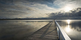
The jetty after which the town was named is located at the end of Archbold Road. The jetty was opened in 1915 and celebrated 100 years in 2015. This provided a cross lake service with Wyong. At the time, some of the main services for Long Jetty were located around The Entrance Road / Archibold Street area including the former post office.
Landmarks
Long Jetty has previously had a number of recreation services for visitors in the caravan parks and tourist accommodations. This includes the former Savoy theatre (part of the R. Wain & Co Pty. Ltd. group) and the Long Jetty Roller Skating rink (currently the paint ball centre). The theatre was, following its closure, a Jewel Supermarket.
Up until the early 1990s, Long Jetty had many financial service organisations, operating mainly as agencies of The Entrance. This included Commonwealth Bank, Westpac, State Building Society (St. George), and State Bank. Whilst the buildings remain between Thompson Street and Pacific Street (backing on to Bank Lane) on The Entrance Road all have closed. In the most recent years Long Jetty has had a mini-revitalisation as a location for new- and second-hand furniture, clothing, children's toys, books, surfing gear and cafés.
Jubilee Oval is located in Long Jetty. It is a cricket oval for The Entrance Cricket Club, together with Taylor Park at The Entrance. After many decades of progressive land acquisition, the Oval crossed Rhodin Drive to link with Sir Baden-Powell Reserve. The reserve is the location of 1st Tuggerah Lakes Scout Group and was also the former location of 2nd Tuggerah Lakes Sea Scouts.
Transportation
Red Bus Services is the local bus operator and operates several routes through Long Jetty, namely routes 21-26 and route 29.
References
- ^ Australian Bureau of Statistics (28 June 2022). "Long Jetty (suburb and locality)". Australian Census 2021 QuickStats. Retrieved 28 June 2022.

External links
Wikimedia Commons has media related to Long Jetty, New South Wales.
- v
- t
- e
Suburbs of the Central Coast, New South Wales
and localities
- Alison
- Avoca Beach
- Bar Point
- Bateau Bay
- Bensville
- Berkeley Vale
- Blackwall
- Blue Bay
- Blue Haven
- Booker Bay
- Bouddi
- Box Head
- Budgewoi
- Budgewoi Peninsula
- Buff Point
- Bushells Ridge
- Calga
- Canton Beach
- Cedar Brush Creek
- Central Mangrove
- Chain Valley Bay
- Charmhaven
- Cheero Point
- Chittaway Bay
- Chittaway Point
- Cogra Bay
- Colongra
- Copacabana
- Crangan Bay
- Daleys Point
- Davistown
- Dooralong
- Doyalson
- Doyalson North
- Durren Durren
- East Gosford
- Empire Bay
- Erina
- Erina Heights
- Ettalong Beach
- Forresters Beach
- Fountaindale
- Glenning Valley
- Glenworth Valley
- Gorokan
- Gosford
- Green Point
- Greengrove
- Gunderman
- Gwandalan
- Halekulani
- Halloran
- Hamlyn Terrace
- Hardys Bay
- Holgate
- Horsfield Bay
- Jilliby
- Kangy Angy
- Kanwal
- Kariong
- Kiar
- Killarney Vale
- Killcare
- Killcare Heights
- Kincumber
- Kincumber South
- Kingfisher Shores
- Koolewong
- Kulnura
- Lake Haven
- Lake Munmorah
- Lemon Tree
- Lisarow
- Little Jilliby
- Little Wobby
- Long Jetty
- Lower Mangrove
- MacMasters Beach
- Magenta
- Mangrove Creek
- Mangrove Mountain
- Mannering Park
- Mardi
- Marlow
- Matcham
- Moonee
- Mooney Mooney
- Mooney Mooney Creek
- Mount Elliot
- Mount White
- Narara
- Niagara Park
- Norah Head
- Noraville
- North Avoca
- North Gosford
- Ourimbah
- Palm Grove
- Palmdale
- Patonga
- Pearl Beach
- Peats Ridge
- Phegans Bay
- Picketts Valley
- Point Clare
- Point Frederick
- Pretty Beach
- Ravensdale
- Rocky Point
- San Remo
- Saratoga
- Shelly Beach
- Somersby
- Spencer
- Springfield
- St Huberts Island
- Summerland Point
- Tacoma
- Tacoma South
- Tascott
- Ten Mile Hollow
- Terrigal
- The Entrance
- The Entrance North
- Toowoon Bay
- Toukley
- Tuggerah
- Tuggerawong
- Tumbi Umbi
- Umina Beach
- Upper Mangrove
- Wadalba
- Wagstaffe
- Wallarah
- Wamberal
- Warnervale
- Watanobbi
- Wendoree Park
- West Gosford
- Wisemans Ferry
- Wondabyne
- Woongarrah
- Woy Woy
- Woy Woy Bay
- Wyee
- Wyoming
- Wyong
- Wyong Creek
- Wyongah
- Yarramalong
- Yattalunga
other waterways
points of interest
33°21′25″S 151°29′06″E / 33.357°S 151.485°E / -33.357; 151.485
 | This Central Coast geography article is a stub. You can help Wikipedia by expanding it. |
- v
- t
- e


