List of islands of Portugal
Map all coordinates using OpenStreetMap
Download coordinates as:
- KML
- GPX (all coordinates)
- GPX (primary coordinates)
- GPX (secondary coordinates)
This is a list of islands of Portugal, including islets (Portuguese: ilhéu or ilhote). The islands (Portuguese: Ilha) are listed by region.[1][2]
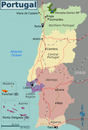
Continental Portugal
Algarve Region
Islands in the Algarve Region include:
- Ilha da Barreta, 36°58′00″N 7°54′00″W / 36.96667°N 7.9°W / 36.96667; -7.9 (Barreta Island)
- Ilha da Culatra, 36°59′20″N 7°50′01″W / 36.98902°N 7.8335°W / 36.98902; -7.8335 (Ilha da Culatra)[3]
- Ilha de Armona, 37°01′50″N 7°46′06″W / 37.03052°N 7.76834°W / 37.03052; -7.76834 (Armona Island)
- Ilha de Cabanas, 37°07′28″N 7°36′37″W / 37.1244685274272°N 7.610167913274704°W / 37.1244685274272; -7.610167913274704 (Ilha de Cabanas)
- Ilha de Cacela, 37°09′07″N 7°32′46″W / 37.152°N 7.546°W / 37.152; -7.546 (Cacela Island)
- Ilha de Tavira, 37°04′43″N 7°40′35″W / 37.07866°N 7.67644°W / 37.07866; -7.67644 (Tavira Island)[3]
- Ilhéu da Geada, 36°59′37″N 7°54′17″W / 36.99354°N 7.90459°W / 36.99354; -7.90459 (Tavira Island)
- Ilhéu da Margalha, 36°59′56″N 7°54′59″W / 36.99889°N 7.91632°W / 36.99889; -7.91632 (Tavira Island)
- Ilhéu das Alturas, 37°00′36″N 7°51′07″W / 37.00999°N 7.85193°W / 37.00999; -7.85193 (Ilhéu das Alturas)
- Ilhéu do Alcorão, 37°00′18″N 7°51′00″W / 37.00511°N 7.85°W / 37.00511; -7.85 (Ilhéu do Alcorão)
- Ilhéu do Barro, 36°58′57″N 7°53′12″W / 36.98257°N 7.88677°W / 36.98257; -7.88677 (Ilhéu do Alcorão)
- Ilha do Coco, 37°01′07″N 7°49′50″W / 37.01866°N 7.83063°W / 37.01866; -7.83063 (Ilha do Coco)
- lhéu do Ramalhete 37°00′07″N 7°58′13″W / 37.00196°N 7.97034°W / 37.00196; -7.97034 (Ilha do Coco)
- Ilhéu dos Gemidos, 37°00′00″N 7°52′00″W / 37°N 7.86667°W / 37; -7.86667 (Ilhéu dos Gemidos)
- Ilhéu Pedra das Gaivotas, 37°01′48″N 8°59′31″W / 37.030028°N 8.991806°W / 37.030028; -8.991806 (Ilha de Cabanas)
- Ilhote da Cobra, 36°59′00″N 7°57′00″W / 36.98333°N 7.95°W / 36.98333; -7.95 (Ilhote da Cobra)
- Ilhote da Cruz, 37°01′00″N 7°52′00″W / 37.01667°N 7.86667°W / 37.01667; -7.86667 (Ilhote da Cruz)
- Ilhote das Ratas, 36°59′00″N 7°56′00″W / 36.98333°N 7.93333°W / 36.98333; -7.93333 (Ilhote das Ratas)
- Ilhote do Pego, 37°01′00″N 7°52′00″W / 37.01667°N 7.86667°W / 37.01667; -7.86667 (Ilhote do Pego)
- Ilhote dos Cavalos, 36°58′37″N 7°55′35″W / 36.97689°N 7.92635°W / 36.97689; -7.92635 (Ilhote dos Cavalos)
- Martinhal (Ilhotes do Martinhal), 37°00′56″N 8°55′02″W / 37.01553°N 8.9173°W / 37.01553; -8.9173 (Ilhotes do Martinhal)
Alentejo Region
The islands in the Alentejo Region include:
- Ariana
- Azenha Brava
- Bacelos
- Bacelos Pequena
- Cascalheira
- Freixial
- Juromenha
- Lebre
- Lezíria Internacional
- Perceveira
- Pessegueiro, 37°50′0.57″N 8°47′51.22″W / 37.8334917°N 8.7975611°W / 37.8334917; -8.7975611 (Pessegueiro Island)
- Moinho
- Monte Branco
- Palmeira
- Palmeira Pequena
- Safra
- São Brás
Central Region
Islands in the Central Region include:
- A Nova
- Agolada
- Almourol, 39°27′43″N 8°23′06″W / 39.462°N 8.385°W / 39.462; -8.385 (Almourol)
- Amoroso
- Baleal, 39°22′23″N 9°20′20″W / 39.3731°N 9.3389°W / 39.3731; -9.3389 (Baleal)
- Bugio, 38°39′37″N 9°17′56″W / 38.66028°N 9.29889°W / 38.66028; -9.29889 (Bugio Lighthouse)
- Cambalhão
- Carmona
- Estrada
- Fora
- Gaga
- Gaivota
- Gramatal
- Idanha
- Lombo
- Marcehal
- Marinha Nova
- Matadouce
- Monte Farinha
- Morraceira
- Mo-do-Meio
- Ovos
- Parrachill
- Pedra
- Poço
- Rato
- Samos
- Testada
- Tranqueria
- Três Postes
- Turbina
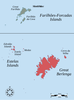
In addition, the archipelago of the Berlengas includes one island and a two-islet group:
- Berlenga Grande, 39°29′56″N 9°31′24″W / 39.49884710540171°N 9.523205315926022°W / 39.49884710540171; -9.523205315926022 (Belenga Grande Island)
- Estelas Islets, 39°27′N 9°32′W / 39.45°N 9.53°W / 39.45; -9.53 (Berlengas Islands)
- Farilhões-Forcados Islets (rocks), 39°28′32″N 9°32′55″W / 39.47562°N 9.5487°W / 39.47562; -9.5487 (Farilhoes rocks)
North Region
The North Region includes the following islands:
- Amores, 41°55′18″N 8°46′15″W / 41.92157°N 8.77087°W / 41.92157; -8.77087 (Amores Island)
- Boega, 41°55′38″N 8°45′47″W / 41.92721°N 8.76299°W / 41.92721; -8.76299 (Boega Island)
- Ermal, 41°35′43″N 8°07′47″W / 41.595279°N 8.129736°W / 41.595279; -8.129736 (ermal Island)
- Insua, 41°51′35″N 8°52′29″W / 41.859805370528214°N 8.874593299337263°W / 41.859805370528214; -8.874593299337263 (Insua Island)[4]
Azores archipelago

The archipelago of the Azores is politically organized as an autonomous region and includes nine islands and the Formigas islet group:
- Corvo, 39°42′6.75″N 31°6′6″W / 39.7018750°N 31.10167°W / 39.7018750; -31.10167 (Corvo Island)
- Faial, 38°34′57″N 28°42′17″W / 38.58250°N 28.70472°W / 38.58250; -28.70472 (Faial Island)
- Flores, 39°26′37″N 31°11′57″W / 39.44361°N 31.19917°W / 39.44361; -31.19917 (Flores Island)[3]
- Graciosa, 39°3′5″N 28°0′51″W / 39.05139°N 28.01417°W / 39.05139; -28.01417 (Graciosa Island)
- Pico, 38°27′57″N 28°20′0″W / 38.46583°N 28.33333°W / 38.46583; -28.33333 (Pico Island)[3]
- Santa Maria, 36°58′29″N 25°05′41″W / 36.97472°N 25.09472°W / 36.97472; -25.09472 (Santa Maria Island)
- São Jorge, 38°38′41″N 28°2′11″W / 38.64472°N 28.03639°W / 38.64472; -28.03639 (São Jorge Island)
- São Miguel, 37°46′43″N 25°29′42″W / 37.77861°N 25.49500°W / 37.77861; -25.49500 (São Miguel Island)[3]
- Terceira, 38°43′40″N 27°12′48″W / 38.72778°N 27.21333°W / 38.72778; -27.21333 (Terceira Island)
- Formigas, 37°16′00″N 24°46′00″W / 37.26667°N 24.76667°W / 37.26667; -24.76667 (Formigas Islets)
Read in detail, Here.
Madeira Archipelago

The archipelago of Madeira is politically organized as an autonomous region and includes two principal islands and two minor island groups:
- Madeira, 32°39′4″N 16°54′35″W / 32.65111°N 16.90972°W / 32.65111; -16.90972 (Madeira Island)[3]
- Porto Santo, 33°03′43.0″N 16°21′23.0″W / 33.061944°N 16.356389°W / 33.061944; -16.356389 (Porto Santo Island)[3]
- Desertas
- Deserta Grande, 32°31′11″N 16°30′27″W / 32.5197°N 16.5075°W / 32.5197; -16.5075 (Deserta Grande Island)
- Bugio, 32°25′35″N 16°29′10″W / 32.42639°N 16.48611°W / 32.42639; -16.48611 (Bugio Island)
- Chão Islet, 32°35′05″N 16°32′40″W / 32.58472°N 16.54444°W / 32.58472; -16.54444 (Chão Islet)
- Selvagens
- Selvagem Grande, 30°08′51″N 15°51′54″W / 30.14750°N 15.86500°W / 30.14750; -15.86500 (Selvagem Grande Island)
- Selvagem Pequena, 30°02′03″N 16°01′37″W / 30.03417°N 16.02694°W / 30.03417; -16.02694 (Selvagem equena Island)
- Palheiro da Terra Islet, 30°09′38″N 15°52′33″W / 30.16053°N 15.87576°W / 30.16053; -15.87576 (Palheiro da Terra Island)
- Palheiro do Mar Islet, 30°09′25″N 15°53′09″W / 30.15697°N 15.88584°W / 30.15697; -15.88584 (Palheiro do Mar)
- Fora Islet, 30°02′N 16°03′W / 30.033°N 16.050°W / 30.033; -16.050 (Fora Islet)
- Alto Islet
- Comprido Islet, 30°02′50″N 16°03′01″W / 30.0471°N 16.05017°W / 30.0471; -16.05017 (Ilheu Comprido)
- Redondo Islet
- Norte Islets
See also
 Islands portal
 Portugal portal


- Exclusive economic zone of Portugal
- List of islands of São Tomé and Príncipe and List of islands of Cape Verde (discovered by Portuguese explorers)
References
- v
- t
- e
| Timeline |
|
|---|---|
| By topic |

|
| Culture | |
|---|---|
| ||
|---|---|---|
| Sovereign states |
|
|
| States with limited recognition |
| |
| Dependencies and other entities | ||
| Authority control databases: National |
|
|---|


