List of historic places on the Avalon Peninsula


Avalon Peninsula
class=notpageimage|
Location of Avalon Peninsula in NewfoundlandThis is a list of historic places on the Avalon Peninsula in the Canadian province of Newfoundland and Labrador. This list contains entries on the Canadian Register of Historic Places, whether they are federal, provincial, or municipal, and excludes the more than 150 listings from the city of St. John's, which are listed separately.
Map all coordinates using OpenStreetMap
Download coordinates as:
- KML
- GPX (all coordinates)
- GPX (primary coordinates)
- GPX (secondary coordinates)
List of historic places
| Name | Address | Coordinates | Government recognition (CRHP №) | Image | |
|---|---|---|---|---|---|
| Admiralty House Museum and Archives | Mount Pearl NL | 47°30′19″N 52°47′46″W / 47.5053°N 52.7961°W / 47.5053; -52.7961 (Admiralty House Museum and Archives) | Mount Pearl municipality (2019) |  Upload Photo | |
| Alderdice Property Municipal Heritage Building | Conception Bay South NL | 47°32′25″N 52°55′48″W / 47.5402°N 52.9299°W / 47.5402; -52.9299 (Alderdice Property Municipal Heritage Building) | Conception Bay South municipality (2062) | Upload Photo | |
| All Saints Anglican Cemetery #1 Municipal Heritage Site | Conception Bay South NL | 47°30′51″N 52°59′01″W / 47.5143°N 52.9837°W / 47.5143; -52.9837 (All Saints Anglican Cemetery #1 Municipal Heritage Site) | Conception Bay South municipality (2292) | Upload Photo | |
| Anderson's Shed Municipal Heritage Site | New Perlican NL | 47°30′51″N 52°59′01″W / 47.5143°N 52.9837°W / 47.5143; -52.9837 (Anderson's Shed Municipal Heritage Site) | New Perlican municipality (19550) | Upload Photo | |
| Anglo American Telegraph Company Cable Office Registered Heritage Structure | Placentia NL | 47°14′51″N 53°57′40″W / 47.2474°N 53.9611°W / 47.2474; -53.9611 (Anglo American Telegraph Company Cable Office Registered Heritage Structure) | Newfoundland and Labrador (3845), Placentia municipality (6249) |  | |
| Argentia 282 Coastal Defence Battery Registered Heritage Structure | Placentia NL | 47°16′24″N 53°59′23″W / 47.2734°N 53.9896°W / 47.2734; -53.9896 (Argentia 282 Coastal Defence Battery Registered Heritage Structure) | Newfoundland and Labrador (3843), Placentia municipality (6122) | Upload Photo | |
| Avondale Railway Station | Avondale NL | 47°24′27″N 53°12′17″W / 47.4074°N 53.2048°W / 47.4074; -53.2048 (Avondale Railway Station) | Newfoundland and Labrador (2102) |  | |
| Bartlett/Burke House | Brigus NL | 47°31′58″N 53°12′31″W / 47.5328°N 53.2085°W / 47.5328; -53.2085 (Bartlett/Burke House) | Newfoundland and Labrador (2050) | Upload Photo | |
| Joseph Bartlett House | Brigus NL | 47°31′59″N 53°12′36″W / 47.533°N 53.2099°W / 47.533; -53.2099 (Joseph Bartlett House) | Newfoundland and Labrador (2226) |  | |
| Bay Bulls Harbour Provincial Historic Site | Shipwreck in the harbour Bay Bulls NL | 47°18′45″N 52°48′28″W / 47.3125°N 52.8079°W / 47.3125; -52.8079 (Bay Bulls Harbour Provincial Historic Site) | Newfoundland and Labrador (3481) | Upload Photo | |
| Bay Roberts Railway Station Municipal Heritage Site | Bay Roberts NL | 47°35′41″N 53°16′29″W / 47.5946°N 53.2746°W / 47.5946; -53.2746 (Bay Roberts Railway Station Municipal Heritage Site) | Newfoundland and Labrador (8003), Bay Roberts municipality (13238) | Upload Photo | |
| Beckett Property | Old Perlican NL | 48°04′59″N 53°00′23″W / 48.0831°N 53.0063°W / 48.0831; -53.0063 (Beckett Property) | Newfoundland and Labrador (1928) |  | |
| Bell Island No. 2 Mine Registered Heritage Structure | Wabana NL | 47°38′47″N 52°56′50″W / 47.6465°N 52.9473°W / 47.6465; -52.9473 (Bell Island No. 2 Mine Registered Heritage Structure) | Newfoundland and Labrador (6245) |  | |
| Bell Rock Municipal Heritage Site | Fermeuse NL | 46°58′36″N 52°57′32″W / 46.9767°N 52.9589°W / 46.9767; -52.9589 (Bell Rock Municipal Heritage Site) | Fermeuse municipality (5313) | Upload Photo | |
| Blessing of the Fleet and Homily Site | Flatrock NL | 47°42′18″N 52°42′37″W / 47.705°N 52.7102°W / 47.705; -52.7102 (Blessing of the Fleet and Homily Site) | Flatrock municipality (4438) |  | |
| Blundon House | Bay de Verde NL | 48°05′11″N 52°53′55″W / 48.0864°N 52.8985°W / 48.0864; -52.8985 (Blundon House) | Newfoundland and Labrador (2096) |  | |
| Mary Boland House Registered Heritage Structure | Calvert NL | 47°03′33″N 52°54′41″W / 47.0592°N 52.9113°W / 47.0592; -52.9113 (Mary Boland House Registered Heritage Structure) | Newfoundland and Labrador (2230) | Upload Photo | |
| Branch Cove Fossiliferous Rocks Municipal Heritage Site | Branch NL | 46°52′09″N 53°57′13″W / 46.8691°N 53.9537°W / 46.8691; -53.9537 (Branch Cove Fossiliferous Rocks Municipal Heritage Site) | Branch municipality (12902) |  | |
| Brigus Historical Zone | Brigus NL | 47°31′58″N 53°12′31″W / 47.5328°N 53.2085°W / 47.5328; -53.2085 (Brigus Historical Zone) | Brigus municipality (5455) | Upload Photo | |
| Bulger, A Name Rock Municipal Heritage Site | Cupids NL | 47°32′51″N 53°13′26″W / 47.5476°N 53.2239°W / 47.5476; -53.2239 (Bulger, A Name Rock Municipal Heritage Site) | Cupids municipality (10851) | Upload Photo | |
| Burgess Fishing Property Municipal Heritage Building | Whiteway NL | 47°40′51″N 53°29′12″W / 47.6809°N 53.4867°W / 47.6809; -53.4867 (Burgess Fishing Property Municipal Heritage Building) | Whiteway municipality (5467) | Upload Photo | |
| Burnt Head Arch Municipal Heritage Site | Cupids NL | 47°34′09″N 53°12′03″W / 47.5692°N 53.2007°W / 47.5692; -53.2007 (Burnt Head Arch Municipal Heritage Site) | Cupids municipality (10855) |  | |
| Burrage's Stage Municipal Heritage Site | New Perlican NL | 47°54′37″N 53°21′32″W / 47.9102°N 53.3588°W / 47.9102; -53.3588 (Burrage's Stage Municipal Heritage Site) | New Perlican municipality (15372) |  | |
| Butler Property | Cupids NL | 47°33′40″N 53°12′38″W / 47.5611°N 53.2105°W / 47.5611; -53.2105 (Butler Property) | Newfoundland and Labrador (2043) |  | |
| Butler's Store Municipal Heritage Building | Conception Bay South NL | 47°30′33″N 52°59′15″W / 47.5093°N 52.9874°W / 47.5093; -52.9874 (Butler's Store Municipal Heritage Building) | Conception Bay South municipality (2058) | Upload Photo | |
| Cable Avenue Municipal Heritage District | Cable Avenue Bay Roberts NL | 47°35′48″N 53°15′14″W / 47.5966°N 53.2538°W / 47.5966; -53.2538 (Cable Avenue Municipal Heritage District) | Newfoundland and Labrador (19611), Bay Roberts municipality (18903) |  | |
| Cable Building National Historic Site of Canada | Water Street Bay Roberts NL | 47°35′48″N 53°15′14″W / 47.5966°N 53.2538°W / 47.5966; -53.2538 (Cable Building National Historic Site of Canada) | Federal (11970), Newfoundland and Labrador (2040), Bay Roberts municipality (13239) | | |
| Cable Staff House #1 | Heart's Content NL | 47°52′25″N 53°22′03″W / 47.8735°N 53.3675°W / 47.8735; -53.3675 (Cable Staff House #1) | Newfoundland and Labrador (2225) |  | |
| Cable Staff House #2 | Heart's Content NL | 47°52′25″N 53°22′03″W / 47.8735°N 53.3675°W / 47.8735; -53.3675 (Cable Staff House #2) | Newfoundland and Labrador (2224) | | |
| Calpin/Myers Property Municipal Heritage Site | Bay Roberts NL | 47°35′38″N 53°15′46″W / 47.5938°N 53.2629°W / 47.5938; -53.2629 (Calpin/Myers Property Municipal Heritage Site) | Bay Roberts municipality (15370) | Upload Photo | |
| Cape Pine Lighthouse National Historic Site of Canada | Cape Pine NL | 46°37′02″N 53°31′57″W / 46.6172°N 53.5326°W / 46.6172; -53.5326 (Cape Pine Lighthouse National Historic Site of Canada) | Federal (10586) | 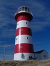 | |
| Cape Pine Lighthouse Recognized Federal Heritage Building | Cape Pine NL | 46°37′02″N 53°31′57″W / 46.6172°N 53.5325°W / 46.6172; -53.5325 (Cape Pine Lighthouse Recognized Federal Heritage Building) | Federal (3634) | 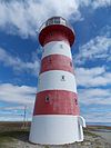 | |
| Cape Race Lighthouse | Cape Race NL | 46°39′46″N 53°04′38″W / 46.6628°N 53.0771°W / 46.6628; -53.0771 (Cape Race Lighthouse) | Federal (3627, (21138) |  | |
| Cape Race Lighthouse National Historic Site of Canada | Cape Race NL | 46°39′31″N 53°04′25″W / 46.6587°N 53.0735°W / 46.6587; -53.0735 (Cape Race Lighthouse National Historic Site of Canada) | Federal (10652) |  | |
| Cape St. Mary's Light Tower | St. Bride's NL | 46°49′23″N 54°11′46″W / 46.8231°N 54.196°W / 46.8231; -54.196 (Cape St. Mary's Light Tower) | Federal (13042, (20779) |  | |
| Castle Hill National Historic Site of Canada | Route 100 Placentia NL | 47°15′05″N 53°58′20″W / 47.2513°N 53.9722°W / 47.2513; -53.9722 (Castle Hill National Historic Site of Canada) | Federal (7565) |  | |
| Cathedral of Immaculate Conception | Harbour Grace NL | 47°41′44″N 53°12′41″W / 47.6956°N 53.2113°W / 47.6956; -53.2113 (Cathedral of Immaculate Conception) | Newfoundland and Labrador (2326) |  | |
| Chapel Cemetery Municipal Heritage Site | Holyrood NL | 47°39′18″N 52°43′33″W / 47.655°N 52.7259°W / 47.655; -52.7259 (Chapel Cemetery Municipal Heritage Site) | Holyrood municipality (10190) | Upload Photo | |
| Chief Operator's House Municipal Heritage Building | Conception Bay South NL | 47°27′22″N 53°04′03″W / 47.4562°N 53.0676°W / 47.4562; -53.0676 (Chief Operator's House Municipal Heritage Building) | Conception Bay South municipality (5935) | Upload Photo | |
| Chisholm House Municipal Heritage Site | Conception Bay South NL | 47°31′15″N 52°57′06″W / 47.5207°N 52.9517°W / 47.5207; -52.9517 (Chisholm House Municipal Heritage Site) | Conception Bay South municipality (12927) | Upload Photo | |
| Codner House and Shed | Torbay NL | 47°39′36″N 52°43′57″W / 47.66°N 52.7325°W / 47.66; -52.7325 (Codner House and Shed) | Torbay municipality (4492) | Upload Photo | |
| Colony of Avalon Special Preservation Area Municipal Heritage District | Ferryland NL | 47°01′22″N 52°52′48″W / 47.0227°N 52.88°W / 47.0227; -52.88 (Colony of Avalon Special Preservation Area Municipal Heritage District) | Federal (19508), Ferryland municipality (14542) | 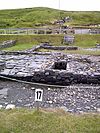 | |
| Aubrey and Elizabeth Crowley Property | Ochre Pit Cove NL | 47°54′33″N 53°04′00″W / 47.9092°N 53.0667°W / 47.9092; -53.0667 (Aubrey and Elizabeth Crowley Property) | Newfoundland and Labrador (1901) |  | |
| Custard Head Fishing Premises | Hant's Harbour NL | 48°00′56″N 53°15′33″W / 48.0155°N 53.2592°W / 48.0155; -53.2592 (Custard Head Fishing Premises) | Newfoundland and Labrador (2199) |  | |
| Davis House | Freshwater NL | 47°45′24″N 53°11′04″W / 47.7567°N 53.1844°W / 47.7567; -53.1844 (Davis House) | Newfoundland and Labrador (1886) |  | |
| Dawe Property World War Two Site Municipal Heritage Site | Flats Road, Manuels Conception Bay South NL | 47°45′24″N 53°11′04″W / 47.7567°N 53.1844°W / 47.7567; -53.1844 (Dawe Property World War Two Site Municipal Heritage Site) | Conception Bay South municipality (18963) | Upload Photo | |
| Devil's Rock | Renews-Cappahayden NL | 46°55′58″N 52°56′42″W / 46.9329°N 52.9451°W / 46.9329; -52.9451 (Devil's Rock) | Renews-Cappahayden municipality (4435) | Upload Photo | |
| The Downs Historic Conservation Area | Ferryland NL | 47°01′08″N 52°51′41″W / 47.019°N 52.8613°W / 47.019; -52.8613 (The Downs Historic Conservation Area) | Ferryland municipality (6119) |  | |
| Drake House Registered Heritage Structure | Arnold's Cove NL | 47°45′58″N 53°59′12″W / 47.766°N 53.9868°W / 47.766; -53.9868 (Drake House Registered Heritage Structure) | Newfoundland and Labrador (1781) |  | |
| Drogheda (Valley of Hope) | Clarke's Beach NL | 47°30′27″N 53°18′30″W / 47.5074°N 53.3084°W / 47.5074; -53.3084 (Drogheda (Valley of Hope)) | Newfoundland and Labrador (1897) | Upload Photo | |
| Ferryland Head Lighthouse Keeper's Dwelling Municipal Heritage Site | Ferryland NL | 47°01′00″N 52°51′28″W / 47.0168°N 52.8577°W / 47.0168; -52.8577 (Ferryland Head Lighthouse Keeper's Dwelling Municipal Heritage Site) | Ferryland municipality (5534) |  | |
| First Anglican Cemetery and War Memorial Site Municipal Heritage Site | Arnold's Cove NL | 47°45′27″N 53°59′24″W / 47.7574°N 53.9899°W / 47.7574; -53.9899 (First Anglican Cemetery and War Memorial Site Municipal Heritage Site) | Arnold's Cove municipality (11941) |  | |
| Fjordheim Property Municipal Heritage Site | Holyrood NL | 47°23′43″N 53°07′12″W / 47.3952°N 53.1199°W / 47.3952; -53.1199 (Fjordheim Property Municipal Heritage Site) | Holyrood municipality (10192) | Upload Photo | |
| Former Carbonear Railway Station (Newfoundland Railway) National Historic Site of Canada | Carbonear NL | 47°44′15″N 53°13′46″W / 47.7375°N 53.2294°W / 47.7375; -53.2294 (Former Carbonear Railway Station (Newfoundland Railway) National Historic Site of Canada) | Federal (14129), Newfoundland and Labrador (1975), Carbonear municipality (12906) |  | |
| Fort Frederick | Placentia NL | 47°14′57″N 53°57′42″W / 47.2492°N 53.9618°W / 47.2492; -53.9618 (Fort Frederick) | Placentia municipality (4067) |  | |
| Fowler House | Brigus NL | 47°32′16″N 53°12′36″W / 47.5378°N 53.2099°W / 47.5378; -53.2099 (Fowler House) | Newfoundland and Labrador (1888) |  | |
| Geehan Building Municipal Heritage Building | Conception Bay South NL | 47°32′23″N 52°55′20″W / 47.5397°N 52.9221°W / 47.5397; -52.9221 (Geehan Building Municipal Heritage Building) | Conception Bay South municipality (7468) | Upload Photo | |
| Goodland House | Harbour Grace NL | 47°41′28″N 53°13′24″W / 47.6912°N 53.2232°W / 47.6912; -53.2232 (Goodland House) | Newfoundland and Labrador (1996) |  | |
| Mark Gosse Residence | Spaniard's Bay NL | 47°36′30″N 53°17′09″W / 47.6083°N 53.2858°W / 47.6083; -53.2858 (Mark Gosse Residence) | Newfoundland and Labrador (2039) |  | |
| John Guy Flag Site Municipal Heritage Structure | Cupids NL | 47°32′52″N 53°13′42″W / 47.5478°N 53.2283°W / 47.5478; -53.2283 (John Guy Flag Site Municipal Heritage Structure) | Cupids municipality (10603) |  | |
| Harbour Grace Court House National Historic Site of Canada | 2 Harvey Street Harbour Grace NL | 47°41′00″N 53°15′45″W / 47.6833°N 53.2625°W / 47.6833; -53.2625 (Harbour Grace Court House National Historic Site of Canada) | Federal (7537) |  | |
| Harbour Grace Fire Bell | Harbour Grace NL | 47°41′25″N 53°13′15″W / 47.6903°N 53.2208°W / 47.6903; -53.2208 (Harbour Grace Fire Bell) | Harbour Grace municipality (4185) | Upload Photo | |
| Harbour Grace Registered Heritage District | Harbour Grace NL | 47°41′35″N 53°12′44″W / 47.693°N 53.2123°W / 47.693; -53.2123 (Harbour Grace Registered Heritage District) | Newfoundland and Labrador (2381) |  | |
| Harry's Brook Municipal Heritage Site | Harry's Brook, running between Tory Road and Harbour Road New Perlican NL | 47°54′32″N 53°21′33″W / 47.9088°N 53.3593°W / 47.9088; -53.3593 (Harry's Brook Municipal Heritage Site) | New Perlican municipality (19549) |  | |
| Hawthorne Cottage National Historic Site of Canada | north side of Irishtown Road Brigus NL | 47°32′07″N 53°12′31″W / 47.5354°N 53.2085°W / 47.5354; -53.2085 (Hawthorne Cottage National Historic Site of Canada) | Federal (16784, (2634) | 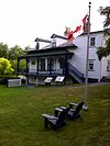 | |
| Hearn House | Brigus NL | 47°32′06″N 53°12′41″W / 47.535°N 53.2113°W / 47.535; -53.2113 (Hearn House) | Newfoundland and Labrador (2229) | Upload Photo | |
| The Hearth Municipal Heritage Site | Branch NL | 46°52′48″N 53°57′13″W / 46.88°N 53.9536°W / 46.88; -53.9536 (The Hearth Municipal Heritage Site) | Branch municipality (12903) | Upload Photo | |
| Heart's Content Cable Station | Heart's Content NL | 47°52′22″N 53°22′11″W / 47.8728°N 53.3696°W / 47.8728; -53.3696 (Heart's Content Cable Station) | Newfoundland and Labrador (3057) |  | |
| Heart's Content Lighthouse | North Point Road, north side of harbour mouth Heart's Content NL | 47°52′56″N 53°23′07″W / 47.8823°N 53.3853°W / 47.8823; -53.3853 (Heart's Content Lighthouse) | Federal (20749, (3975) |  | |
| Heart's Content Registered Historic District | Central village of Heart's Content Heart's Content NL | 47°52′56″N 53°23′07″W / 47.8823°N 53.3853°W / 47.8823; -53.3853 (Heart's Content Registered Historic District) | Newfoundland and Labrador (19612) |  | |
| The Herder Property Municipal Heritage Site | Conception Bay South NL | 47°31′47″N 52°57′28″W / 47.5298°N 52.9579°W / 47.5298; -52.9579 (The Herder Property Municipal Heritage Site) | Conception Bay South municipality (13257) | Upload Photo | |
| The Hermitage Registered Heritage Structure | Conception Bay South NL | 47°32′14″N 52°56′14″W / 47.5373°N 52.9372°W / 47.5373; -52.9372 (The Hermitage Registered Heritage Structure) | Newfoundland and Labrador (5934), Conception Bay South municipality (14002) |  | |
| Heyfield Memorial United Church and Cemetery Municipal Heritage Site | Water side of Route 80 Heart's Content NL | 47°53′44″N 53°22′05″W / 47.8955°N 53.3681°W / 47.8955; -53.3681 (Heyfield Memorial United Church and Cemetery Municipal Heritage Site) | Newfoundland and Labrador (19411), Heart's Content municipality (7307) | | |
| Historic Ferryland Museum Municipal Heritage Site | Ferryland NL | 47°01′35″N 52°53′04″W / 47.0263°N 52.8845°W / 47.0263; -52.8845 (Historic Ferryland Museum Municipal Heritage Site) | Ferryland municipality (5533) |  | |
| Holy Apostles Church | Renews-Cappahayden NL | 46°55′42″N 52°54′41″W / 46.9282°N 52.9113°W / 46.9282; -52.9113 (Holy Apostles Church) | Newfoundland and Labrador (2110) |  | |
| Holy Trinity Convent and Chapel Registered Heritage Structure | Witless Bay NL | 47°16′52″N 52°49′53″W / 47.2811°N 52.8314°W / 47.2811; -52.8314 (Holy Trinity Convent and Chapel Registered Heritage Structure) | Newfoundland and Labrador (3761) |  | |
| Holy Trinity Roman Catholic Church Registered Heritage Structure | Ferryland NL | 47°01′31″N 52°53′04″W / 47.0252°N 52.8845°W / 47.0252; -52.8845 (Holy Trinity Roman Catholic Church Registered Heritage Structure) | Newfoundland and Labrador (1939) |  | |
| Immaculate Conception Cemetery Municipal Heritage Site | Cape Broyle NL | 47°05′55″N 52°56′29″W / 47.0985°N 52.9414°W / 47.0985; -52.9414 (Immaculate Conception Cemetery Municipal Heritage Site) | Cape Broyle municipality (5764) |  | |
| Immaculate Conception Church and Grounds Municipal Heritage Site | Cape Broyle NL | 47°05′47″N 52°56′41″W / 47.0964°N 52.9447°W / 47.0964; -52.9447 (Immaculate Conception Church and Grounds Municipal Heritage Site) | Cape Broyle municipality (5865) |  | |
| Bernard Kavanagh Premises Municipal Heritage Site | Ferryland NL | 47°01′25″N 52°53′02″W / 47.0237°N 52.8839°W / 47.0237; -52.8839 (Bernard Kavanagh Premises Municipal Heritage Site) | Ferryland municipality (5456) |  | |
| Keneally House | Carbonear NL | 47°44′20″N 53°13′50″W / 47.739°N 53.2306°W / 47.739; -53.2306 (Keneally House) | Newfoundland and Labrador (2103) |  | |
| Mother M. Bernard Kirwan Memorial Municipal Heritage Site | Port Kirwan NL | 46°58′10″N 52°54′34″W / 46.9694°N 52.9095°W / 46.9694; -52.9095 (Mother M. Bernard Kirwan Memorial Municipal Heritage Site) | Port Kirwan municipality (7278) |  | |
| Lakeview Registered Heritage Structure | Brigus NL | 47°32′01″N 53°12′30″W / 47.5337°N 53.2082°W / 47.5337; -53.2082 (Lakeview Registered Heritage Structure) | Newfoundland and Labrador (8005) | Upload Photo | |
| Landfall (Kent Cottage) Registered Heritage Structure | Brigus NL | 47°32′32″N 53°12′12″W / 47.5423°N 53.2032°W / 47.5423; -53.2032 (Landfall (Kent Cottage) Registered Heritage Structure) | Newfoundland and Labrador (2273) |  | |
| The Liberal Rock Municipal Heritage Site | Peddle's Lane New Perlican NL | 47°54′38″N 53°21′23″W / 47.9105°N 53.3564°W / 47.9105; -53.3564 (The Liberal Rock Municipal Heritage Site) | New Perlican municipality (19530) | Upload Photo | |
| Lighttower | Bull Head Bay Bulls NL | 47°18′39″N 52°44′50″W / 47.3107°N 52.7471°W / 47.3107; -52.7471 (Lighttower (Bull Head Light)) | Federal (9729) |  | |
| Lighttower | Brigus NL | 47°32′54″N 53°10′56″W / 47.5484°N 53.1821°W / 47.5484; -53.1821 (Lighttower (North Head Light)) | Federal (3992) | Upload Photo | |
| Lloyd George House | Dildo NL | 47°34′05″N 53°33′19″W / 47.5681°N 53.5554°W / 47.5681; -53.5554 (Lloyd George House) | Newfoundland and Labrador (1929) | Upload Photo | |
| Loyal Orange Lodge LOL #9 | Green's Harbour NL | 47°37′59″N 53°30′36″W / 47.6331°N 53.51°W / 47.6331; -53.51 (Loyal Orange Lodge LOL #9) | Newfoundland and Labrador (2198) | Upload Photo | |
| Lulah-Oh! / Carroll Property Municipal Heritage Site | Holyrood NL | 47°23′19″N 53°08′11″W / 47.3887°N 53.1363°W / 47.3887; -53.1363 (Lulah-Oh! / Carroll Property Municipal Heritage Site) | Holyrood municipality (8371) |  | |
| Manuels River Linear Park Municipal Heritage Site | Conception Bay South NL | 47°31′15″N 52°56′46″W / 47.5207°N 52.9462°W / 47.5207; -52.9462 (Manuels River Linear Park Municipal Heritage Site) | Conception Bay South municipality (10638) |  | |
| The Maples | Harbour Grace NL | 47°41′34″N 53°12′55″W / 47.6927°N 53.2153°W / 47.6927; -53.2153 (The Maples) | Harbour Grace municipality (4192) |  | |
| Markland Cottage Hospital Registered Heritage Structure | Markland NL | 47°24′10″N 53°32′41″W / 47.4027°N 53.5448°W / 47.4027; -53.5448 (Markland Cottage Hospital Registered Heritage Structure) | Newfoundland and Labrador (7784) | Upload Photo | |
| Masonic Lodge Harbour Grace #476 A.F. and A.M., S.C | Harbour Grace NL | 47°41′29″N 53°13′21″W / 47.6914°N 53.2224°W / 47.6914; -53.2224 (Masonic Lodge Harbour Grace #476 A.F. and A.M., S.C) | Harbour Grace municipality (4189) |  | |
| Metcalfe Slaughter House and Barn, Upper Barn, Office and Shed Municipal Heritage Site | Conception Bay South NL | 47°31′32″N 52°56′41″W / 47.5255°N 52.9446°W / 47.5255; -52.9446 (Metcalfe Slaughter House and Barn, Upper Barn, Office and Shed Municipal Heritage Site) | Conception Bay South municipality (14622) | Upload Photo | |
| Midnight Hill and Grotto de Lourdes on Mass Rock Municipal Heritage Site | Renews-Cappahayden NL | 46°55′43″N 52°55′58″W / 46.9287°N 52.9327°W / 46.9287; -52.9327 (Midnight Hill and Grotto de Lourdes on Mass Rock Municipal Heritage Site) | Renews-Cappahayden municipality (4683) |  | |
| Miller House Municipal Heritage Site | Conception Bay South NL | 47°32′24″N 52°55′41″W / 47.5399°N 52.928°W / 47.5399; -52.928 (Miller House Municipal Heritage Site) | Conception Bay South municipality (16263) | Upload Photo | |
| Paddy Miller House Municipal Heritage Building | Southern Harbour NL | 47°42′32″N 53°58′12″W / 47.709°N 53.97°W / 47.709; -53.97 (Paddy Miller House Municipal Heritage Building) | Southern Harbour municipality (8146) | Upload Photo | |
| Morgan House | Conception Bay South NL | 47°27′23″N 53°05′20″W / 47.4565°N 53.0888°W / 47.4565; -53.0888 (Morgan House) | Newfoundland and Labrador (2174), Conception Bay South municipality (14001) | Upload Photo | |
| Mosquito School House | Bristol's Hope NL | 47°43′06″N 53°11′31″W / 47.7183°N 53.192°W / 47.7183; -53.192 (Mosquito School House) | Newfoundland and Labrador (2052) | Upload Photo | |
| North Side Burial Ground Municipal Heritage Site | Ferryland NL | 47°01′53″N 52°53′00″W / 47.0314°N 52.8834°W / 47.0314; -52.8834 (North Side Burial Ground Municipal Heritage Site) | Ferryland municipality (12907) | Upload Photo | |
| R.J. O'Brien's General Store | Cape Broyle NL | 47°05′45″N 52°56′55″W / 47.0959°N 52.9486°W / 47.0959; -52.9486 (R.J. O'Brien's General Store) | Newfoundland and Labrador (3844) |  | |
| The Old Bark Pot Municipal Heritage Site | Along Beach Road in The Pool Ferryland NL | 47°44′20″N 53°13′29″W / 47.7389°N 53.2247°W / 47.7389; -53.2247 (The Old Bark Pot Municipal Heritage Site) | Ferryland municipality (18944) |  | |
| Old Carbonear Post Office | Carbonear NL | 47°44′20″N 53°13′29″W / 47.7389°N 53.2247°W / 47.7389; -53.2247 (Old Carbonear Post Office) | Newfoundland and Labrador (1851) |  | |
| Old Cemetery | Renews-Cappahayden NL | 46°55′25″N 52°55′52″W / 46.9235°N 52.9311°W / 46.9235; -52.9311 (Old Cemetery) | Renews-Cappahayden municipality (4437) |  | |
| Old Cemetery Municipal Heritage Site | Port Kirwan NL | 46°58′15″N 52°54′35″W / 46.9707°N 52.9098°W / 46.9707; -52.9098 (Old Cemetery Municipal Heritage Site) | Port Kirwan municipality (5050) |  | |
| The Old Graveyard Municipal Heritage Site | Branch NL | 46°52′52″N 53°57′06″W / 46.8812°N 53.9517°W / 46.8812; -53.9517 (The Old Graveyard Municipal Heritage Site) | Branch municipality (12904) | Upload Photo | |
| Old Holy Trinity Parish Cemetery Municipal Heritage Site | Torbay NL | 47°39′17″N 52°43′33″W / 47.6547°N 52.7259°W / 47.6547; -52.7259 (Old Holy Trinity Parish Cemetery Municipal Heritage Site) | Torbay municipality (8243) | Upload Photo | |
| Old Lighthouse Site Municipal Heritage Site | Cupids NL | 47°33′18″N 53°13′36″W / 47.5549°N 53.2267°W / 47.5549; -53.2267 (Old Lighthouse Site Municipal Heritage Site) | Cupids municipality (10853) |  | |
| Old St. Nicholas Anglican Cemetery Municipal Heritage Site | Torbay NL | 47°39′36″N 52°43′53″W / 47.66°N 52.7315°W / 47.66; -52.7315 (Old St. Nicholas Anglican Cemetery Municipal Heritage Site) | Torbay municipality (8147) | Upload Photo | |
| Old Witless Bay Cemetery | Witless Bay NL | 47°16′47″N 52°49′19″W / 47.2798°N 52.822°W / 47.2798; -52.822 (Old Witless Bay Cemetery) | Witless Bay municipality (5052) | Upload Photo | |
| O'Reilly House Registered Heritage Structure | 48 Orcan Drive Placentia NL | 47°14′46″N 53°57′36″W / 47.2462°N 53.9599°W / 47.2462; -53.9599 (O'Reilly House Registered Heritage Structure) | Newfoundland and Labrador (2233), Placentia municipality (6120) |  | |
| Otterbury School House | Harbour Grace NL | 47°40′35″N 53°15′01″W / 47.6763°N 53.2502°W / 47.6763; -53.2502 (Otterbury School House) | Harbour Grace municipality (4191) |  | |
| Our Lady of Angels / Presentation Convent Registered Heritage Structure | Placentia NL | 47°14′39″N 53°57′41″W / 47.2441°N 53.9615°W / 47.2441; -53.9615 (Our Lady of Angels / Presentation Convent Registered Heritage Structure) | Newfoundland and Labrador (2234), Placentia municipality (6248) | 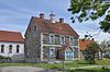 | |
| Our Lady of Lourdes Grotto | Flatrock NL | 47°42′18″N 52°42′48″W / 47.705°N 52.7133°W / 47.705; -52.7133 (Our Lady of Lourdes Grotto) | Flatrock municipality (4502) |  | |
| John Parot's Grave Municipal Heritage Site | Old Perlican NL | 48°05′07″N 53°00′12″W / 48.0853°N 53.0034°W / 48.0853; -53.0034 (John Parot's Grave Municipal Heritage Site) | Old Perlican municipality (5668) | Upload Photo | |
| Payne House | Harbour Grace NL | 47°41′23″N 53°13′31″W / 47.6896°N 53.2252°W / 47.6896; -53.2252 (Payne House) | Newfoundland and Labrador (1997) |  | |
| Peter's Finger Municipal Heritage Site | A large outcrop of rock located in the southwestern corner of New Perlican, west of Route 80 and south of Vitter's Cove Road. New Perlican NL | 47°54′29″N 53°22′15″W / 47.9080°N 53.3708°W / 47.9080; -53.3708 (Peter's Finger Municipal Heritage Site) | New Perlican municipality (18907) |  | |
| Petty Harbour Hydro-Electric Generating Station | Petty Harbour NL | 47°27′55″N 52°42′43″W / 47.4652°N 52.7119°W / 47.4652; -52.7119 (Petty Harbour Hydro-Electric Generating Station) | Newfoundland and Labrador (4326) | 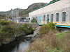 | |
| Gordon G. Pike Railway Heritage Museum and Park | Harbour Grace NL | 47°41′45″N 53°13′06″W / 47.6958°N 53.2184°W / 47.6958; -53.2184 (Gordon G. Pike Railway Heritage Museum and Park) | Harbour Grace municipality (4184) |  | |
| Pinehurst | Carbonear NL | 47°44′20″N 53°13′18″W / 47.7388°N 53.2217°W / 47.7388; -53.2217 (Pinehurst) | Newfoundland and Labrador (2073) |  | |
| The Plot Municipal Heritage Site | Branch NL | 46°52′53″N 53°57′06″W / 46.8814°N 53.9516°W / 46.8814; -53.9516 (The Plot Municipal Heritage Site) | Branch municipality (12911) | Upload Photo | |
| Porter House | Port de Grave NL | 47°36′02″N 53°11′06″W / 47.6006°N 53.185°W / 47.6006; -53.185 (Porter House) | Newfoundland and Labrador (2042) | Upload Photo | |
| Powell House | Carbonear NL | 47°44′27″N 53°12′35″W / 47.7407°N 53.2098°W / 47.7407; -53.2098 (Powell House) | Newfoundland and Labrador (2053) |  | |
| Presentation Cemetery Municipal Heritage Site | Renews-Cappahayden NL | 46°55′43″N 52°56′01″W / 46.9287°N 52.9336°W / 46.9287; -52.9336 (Presentation Cemetery Municipal Heritage Site) | Renews-Cappahayden municipality (5051) |  | |
| Presentation Convent Grounds Municipal Heritage Site | Renews-Cappahayden NL | 46°55′43″N 52°55′59″W / 46.9285°N 52.9331°W / 46.9285; -52.9331 (Presentation Convent Grounds Municipal Heritage Site) | Renews-Cappahayden municipality (5385) |  | |
| Prince of Orange Loyal Orange Lodge LOL#23 Municipal Heritage Building | Conception Bay South NL | 47°30′18″N 53°00′20″W / 47.505°N 53.0055°W / 47.505; -53.0055 (Prince of Orange Loyal Orange Lodge LOL#23 Municipal Heritage Building) | Conception Bay South municipality (2059) | Upload Photo | |
| Reid's General Store | Heart's Delight-Islington NL | 47°46′16″N 53°27′54″W / 47.771°N 53.465°W / 47.771; -53.465 (Reid's General Store) | Newfoundland and Labrador (2227) | Upload Photo | |
| Abram Richards Property | Bareneed NL | 47°34′09″N 53°15′34″W / 47.5691°N 53.2595°W / 47.5691; -53.2595 (Abram Richards Property) | Newfoundland and Labrador (1785) | Upload Photo | |
| Ridley Hall Ruins Registered Heritage Structure | Harbour Grace NL | 47°41′34″N 53°12′55″W / 47.6927°N 53.2153°W / 47.6927; -53.2153 (Ridley Hall Ruins Registered Heritage Structure) | Newfoundland and Labrador (8582) |  | |
| Ridley Office | Harbour Grace NL | 47°41′29″N 53°13′00″W / 47.6913°N 53.2166°W / 47.6913; -53.2166 (Ridley Office) | Newfoundland and Labrador (2317) |  | |
| The Road House Municipal Heritage Site | Conception Bay South NL | 47°32′20″N 52°56′11″W / 47.5388°N 52.9364°W / 47.5388; -52.9364 (The Road House Municipal Heritage Site) | Conception Bay South municipality (16264) | Upload Photo | |
| Rock with 17th and 18th Century Graffiti Municipal Heritage Site | Fermeuse NL | 46°57′44″N 52°56′11″W / 46.9623°N 52.9363°W / 46.9623; -52.9363 (Rock with 17th and 18th Century Graffiti Municipal Heritage Site) | Fermeuse municipality (5962) | Upload Photo | |
| Rock with 19th Century Graffiti Carvings Municipal Heritage Site | Fermeuse NL | 46°57′40″N 52°54′40″W / 46.961°N 52.911°W / 46.961; -52.911 (Rock with 19th Century Graffiti Carvings Municipal Heritage Site) | Fermeuse municipality (5967) | Upload Photo | |
| Roman Catholic Parish Cemetery | Harbour Grace NL | 47°41′33″N 53°13′04″W / 47.6924°N 53.2177°W / 47.6924; -53.2177 (Roman Catholic Parish Cemetery) | Harbour Grace municipality (4190) |  | |
| Rorke's Stone Jug | Carbonear NL | 47°44′18″N 53°13′47″W / 47.7384°N 53.2296°W / 47.7384; -53.2296 (Rorke's Stone Jug) | Newfoundland and Labrador (2143) |  | |
| Rorke Store | Carbonear NL | 47°44′18″N 53°13′32″W / 47.7384°N 53.2256°W / 47.7384; -53.2256 (Rorke Store) | Newfoundland and Labrador (1881) |  | |
| Rothesay House, Munn/Godden Residence | Harbour Grace NL | 47°41′37″N 53°12′46″W / 47.6937°N 53.2127°W / 47.6937; -53.2127 (Rothesay House, Munn/Godden Residence) | Newfoundland and Labrador (3305) |  | |
| Rural Retreat (Peach's Farm) | Carbonear NL | 47°44′51″N 53°13′15″W / 47.7475°N 53.2209°W / 47.7475; -53.2209 (Rural Retreat (Peach's Farm)) | Newfoundland and Labrador (2142) | Upload Photo | |
| St. Charles Borromeo Church and Grounds Municipal Heritage Site | Fermeuse NL | 46°58′39″N 52°57′31″W / 46.9775°N 52.9587°W / 46.9775; -52.9587 (St. Charles Borromeo Church and Grounds Municipal Heritage Site) | Fermeuse municipality (5532) |  | |
| St. George's Anglican Church | Brigus NL | 47°32′11″N 53°12′27″W / 47.5365°N 53.2075°W / 47.5365; -53.2075 (St. George's Anglican Church) | Newfoundland and Labrador (2076) |  | |
| St. James Anglican Church Registered Heritage Structure | Carbonear NL | 47°44′30″N 53°13′27″W / 47.7418°N 53.2242°W / 47.7418; -53.2242 (St. James Anglican Church Registered Heritage Structure) | Newfoundland and Labrador (2041) |  | |
| St. John the Evangelist Anglican Church Municipal Heritage Site | Conception Bay South NL | 47°32′14″N 52°56′14″W / 47.5372°N 52.9372°W / 47.5372; -52.9372 (St. John the Evangelist Anglican Church Municipal Heritage Site) | Newfoundland and Labrador (2179), Conception Bay South municipality (13716) |  | |
| St. John the Evangelist Cemetery Municipal Heritage Site | Conception Bay South NL | 47°32′14″N 52°56′14″W / 47.5373°N 52.9372°W / 47.5373; -52.9372 (St. John the Evangelist Cemetery Municipal Heritage Site) | Conception Bay South municipality (7466) |  | |
| St. Luke's Cultural Heritage Centre | Bankers Rd Placentia NL | 47°14′46″N 53°57′42″W / 47.2462°N 53.9616°W / 47.2462; -53.9616 (St. Luke's Cultural Heritage Centre) | Newfoundland and Labrador (2327), Placentia municipality (6247) |  | |
| St. Matthew's United Church Southside Cemetery Municipal Heritage Site | New Perlican NL | 47°54′40″N 53°21′24″W / 47.911°N 53.3567°W / 47.911; -53.3567 (St. Matthew's United Church Southside Cemetery Municipal Heritage Site) | New Perlican municipality (14004) |  | |
| St. Paul's Anglican Church | Harbour Grace NL | 47°41′44″N 53°13′02″W / 47.6956°N 53.2173°W / 47.6956; -53.2173 (St. Paul's Anglican Church) | Newfoundland and Labrador (2144) |  | |
| St. Peter's Anglican Church and Cemetery Municipal Heritage Site | Conception Bay South NL | 47°28′43″N 53°03′14″W / 47.4787°N 53.0539°W / 47.4787; -53.0539 (St. Peter's Anglican Church and Cemetery Municipal Heritage Site) | Conception Bay South municipality (2063) |  | |
| St. Thomas of Villa Nova Cemetery Municipal Heritage Site | Conception Bay South NL | 47°31′25″N 52°56′51″W / 47.5235°N 52.9475°W / 47.5235; -52.9475 (St. Thomas of Villa Nova Cemetery Municipal Heritage Site) | Conception Bay South municipality (7467) |  | |
| Salvation Army Cemetery Municipal Heritage Site | Arnold's Cove NL | 47°45′21″N 53°59′37″W / 47.7559°N 53.9937°W / 47.7559; -53.9937 (Salvation Army Cemetery Municipal Heritage Site) | Arnold's Cove municipality (11940) |  | |
| Second Anglican Cemetery Municipal Heritage Site | Arnold's Cove NL | 47°45′19″N 53°59′24″W / 47.7552°N 53.99°W / 47.7552; -53.99 (Second Anglican Cemetery Municipal Heritage Site) | Arnold's Cove municipality (11942) | Upload Photo | |
| Shano/Le Shane Property Registered Heritage Structure | Lower Island Cove NL | 48°00′31″N 52°58′31″W / 48.0086°N 52.9754°W / 48.0086; -52.9754 (Shano/Le Shane Property Registered Heritage Structure) | Newfoundland and Labrador (6246) |  | |
| Sittin' Rock Municipal Heritage Site | New Perlican NL | 47°54′15″N 53°21′25″W / 47.9041°N 53.357°W / 47.9041; -53.357 (Sittin' Rock Municipal Heritage Site) | New Perlican municipality (14003) | Upload Photo | |
| Society of United Fishermen Lodge SUF #1 | Heart's Content NL | 47°52′30″N 53°22′11″W / 47.875°N 53.3698°W / 47.875; -53.3698 (Society of United Fishermen Lodge SUF #1) | Newfoundland and Labrador (2202) |  | |
| Somerton Property | Wabana NL | 47°38′47″N 52°56′47″W / 47.6465°N 52.9465°W / 47.6465; -52.9465 (Somerton Property) | Newfoundland and Labrador (1866) | Upload Photo | |
| South Side Burial Ground Municipal Heritage Site | Ferryland NL | 47°01′25″N 52°53′08″W / 47.0236°N 52.8856°W / 47.0236; -52.8856 (South Side Burial Ground Municipal Heritage Site) | Ferryland municipality (12908) | Upload Photo | |
| Spaniard's Bay United Church Registered Heritage Structure | Spaniard's Bay NL | 47°37′15″N 53°16′35″W / 47.6209°N 53.2764°W / 47.6209; -53.2764 (Spaniard's Bay United Church Registered Heritage Structure) | Newfoundland and Labrador (7783), Spaniard's Bay municipality (6192) | Upload Photo | |
| Stone Barn | Brigus NL | 47°32′08″N 53°12′35″W / 47.5355°N 53.2098°W / 47.5355; -53.2098 (Stone Barn) | Newfoundland and Labrador (1671) |  | |
| Topsail United Church Cemetery Municipal Heritage Site | Conception Bay South NL | 47°32′21″N 52°56′14″W / 47.5393°N 52.9373°W / 47.5393; -52.9373 (Topsail United Church Cemetery Municipal Heritage Site) | Conception Bay South municipality (2291) |  | |
| Tower | Ferryland NL | 47°54′29″N 53°21′29″W / 47.908°N 53.358°W / 47.908; -53.358 (Tower (Ferryland Head Light)) | Federal (4728) |  | |
| Town of New Perlican Heritage Conservation Zone Municipal Heritage District | New Perlican NL | 47°54′29″N 53°21′29″W / 47.908°N 53.358°W / 47.908; -53.358 (Town of New Perlican Heritage Conservation Zone Municipal Heritage District) | New Perlican municipality (8148) |  | |
| Trahey Property | Conception Harbour NL | 47°26′27″N 53°12′27″W / 47.4409°N 53.2075°W / 47.4409; -53.2075 (Trahey Property) | Newfoundland and Labrador (2182) | Upload Photo | |
| Upper Gullies United Church Cemetery Municipal Heritage Site | Conception Bay South NL | 47°29′05″N 53°02′37″W / 47.4847°N 53.0437°W / 47.4847; -53.0437 (Upper Gullies United Church Cemetery Municipal Heritage Site) | Conception Bay South municipality (14683) |  | |
| Veitch Property Municipal Heritage Site | Holyrood NL | 47°23′14″N 53°08′10″W / 47.3872°N 53.136°W / 47.3872; -53.136 (Veitch Property Municipal Heritage Site) | Holyrood municipality (10193) | Upload Photo | |
| Victoria Hydro-Electric Generating Station | Victoria NL | 47°46′31″N 53°12′55″W / 47.7752°N 53.2154°W / 47.7752; -53.2154 (Victoria Hydro-Electric Generating Station) | Newfoundland and Labrador (4327) | 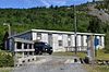 | |
| Victoria Manor | Harbour Grace NL | 47°41′32″N 53°13′26″W / 47.6921°N 53.224°W / 47.6921; -53.224 (Victoria Manor) | Newfoundland and Labrador (2044) |  | |
| Wakeham Sawmill Registered Heritage Structure | Placentia NL | 47°14′44″N 53°57′31″W / 47.2456°N 53.9586°W / 47.2456; -53.9586 (Wakeham Sawmill Registered Heritage Structure) | Newfoundland and Labrador (4041), Placentia municipality (6123) |  | |
| Walled Landscape of Grates Cove National Historic Site of Canada | Grates Cove NL | 48°10′00″N 52°56′00″W / 48.1667°N 52.9333°W / 48.1667; -52.9333 (Walled Landscape of Grates Cove National Historic Site of Canada) | Federal (12745) |  | |
| War Memorial Municipal Heritage Site | Branch NL | 46°52′54″N 53°57′24″W / 46.8817°N 53.9567°W / 46.8817; -53.9567 (War Memorial Municipal Heritage Site) | Branch municipality (12905) |  | |
| Waterloo Loyal Orange Lodge No. 18 Municipal Heritage Site | New Perlican NL | 47°54′30″N 53°21′29″W / 47.9084°N 53.358°W / 47.9084; -53.358 (Waterloo Loyal Orange Lodge No. 18 Municipal Heritage Site) | New Perlican municipality (14413) |  | |
| 62 Water Street | 62 Water Street Carbonear NL | 47°44′27″N 53°12′30″W / 47.7409°N 53.2082°W / 47.7409; -53.2082 (62 Water Street) | Newfoundland and Labrador (1993) |  | |
| West End Mercantile Establishment | Harbour Grace NL | 47°41′23″N 53°13′31″W / 47.6896°N 53.2252°W / 47.6896; -53.2252 (West End Mercantile Establishment) | Newfoundland and Labrador (3081) |  | |
| Western Bay Railway Station | Western Bay NL | 47°52′49″N 53°05′13″W / 47.8802°N 53.0869°W / 47.8802; -53.0869 (Western Bay Railway Station) | Newfoundland and Labrador (2067) |  | |
| West Point Cemetery Municipal Heritage Site | Portugal Cove-St. Philip's NL | 47°37′24″N 52°51′58″W / 47.6234°N 52.8662°W / 47.6234; -52.8662 (West Point Cemetery Municipal Heritage Site) | Portugal Cove-St. Philip's municipality (12064) | Upload Photo | |
| White House | Portugal Cove NL | 47°37′21″N 52°51′38″W / 47.6225°N 52.8606°W / 47.6225; -52.8606 (White House) | Newfoundland and Labrador (3842) | Upload Photo | |
| Winter Home | Clarke's Beach NL | 47°32′29″N 53°16′29″W / 47.5415°N 53.2748°W / 47.5415; -53.2748 (Winter Home) | Newfoundland and Labrador (2055) |  | |
| Women's Patriotic Association War Memorial Municipal Heritage Site | Sunnyside NL | 47°51′30″N 53°55′20″W / 47.8583°N 53.9221°W / 47.8583; -53.9221 (Women's Patriotic Association War Memorial Municipal Heritage Site) | Sunnyside municipality (7465) |  |
See also
- List of historic places in Newfoundland and Labrador
- List of National Historic Sites of Canada in Newfoundland and Labrador
- v
- t
- e
- CRHP
- St. John's
- Avalon Peninsula
- Labrador
- Western Newfoundland
- Central Newfoundland
- Bonavista Bay
- Cape Spear Lighthouse
- Castle Hill
- Hawthorne Cottage
- Hopedale Mission
- Kitjigattalik - Ramah Chert Quarries
- L'Anse aux Meadows
- Port au Choix
- Ryan Premises
- Signal Hill
- more...
Ecological Reserves
 Category
- St. John's geography
 Commons


