List of heritage sites near Cape Town
Sites recognised ny SAHRA
Map all coordinates using OpenStreetMap
Download coordinates as:
- KML
- GPX (all coordinates)
- GPX (primary coordinates)
- GPX (secondary coordinates)
This is a list of the heritage sites near Cape Town as recognized by the South African Heritage Resources Agency.[1]
For additional provincial heritage sites declared by Heritage Western Cape, the provincial heritage resources authority of the Western Cape Province of South Africa, please see the entries at the end of the list. These sites have been declared subsequent to the implementation of the new legislation on 1 April 2000 and unlike those in the SAHRA portion of the list are not former national monuments declared by the former National Monuments Council, the predecessor of both SAHRA and Heritage Western Cape.[2] In the instance of these sites the "identifier" code used is that of Heritage Western Cape rather than SAHRA.
| SAHRA identifier | Site name | Description | Town | District | NHRA status | Coordinates | Image |
|---|---|---|---|---|---|---|---|
| 9/2/018/0001 | Fort Wynyard, Green Point, Cape Town | Fort Wynyard was erected in 1860 near the site where the Dutch East India Company's battery "Kyk in de Pot", which was dismantled between 1825 and 1827, stood. The fort was named after Lt-Gen. R. H. Wynyard, the then Lieutenant-Governor of the Cape Colony Type of site: Fort. | Cape Town, Green Point | The Cape | Provincial Heritage Site | 33°54′12″S 18°24′50″E / 33.903345°S 18.413875°E / -33.903345; 18.413875 (SAHRA identifier 9/2/018/0001 - Fort Wynyard, Green Point, Cape Town) |  |
| 9/2/018/0002 | Valkenberg, Observatory, Cape Town | Built on land granted in 1661, the Valkenburg Homestead is one of the only original homesteads still standing on the Liesbeeck River. It was named after Cornelius Valck who became the owner in 1720. The north wing, with its curvilinear parapet, was added later Type of site: Farmstead | Cape Town, Observatory | The Cape | Provincial Heritage Site | 33°56′31″S 18°28′46″E / 33.942075°S 18.479581°E / -33.942075; 18.479581 (SAHRA identifier 9/2/018/0002 - Valkenberg, Observatory, Cape Town) |  Type of site: Farmstead Current use: Hotel, restaurant & vault. |
| 9/2/018/0002/01 | Black River/Liesbeeck River, Confluence Area, Observatory | An ecologically and historically significant site where the Liesbeeck River merges with the Black River. The Liesbeeck River originates from the eastern slopes of Table Mountain, while the Black River flows from the northern suburbs. This confluence creates a wetland ecosystem that supports diverse bird species, fish, and other aquatic life, making it a vital ecological habitat. Historically, the area holds substantial cultural importance, reflecting the interactions between the indigenous Khoisan people and early European settlers. The rivers played a crucial role in the development of Cape Town, providing water for agriculture and settlement. | 33°55′48″S 18°28′42″E / 33.929863°S 18.478250°E / -33.929863; 18.478250 (SAHRA identifier 9/2/018/0002/01 - Black River/Liesbeeck River, Confluence Area, Observatory) | | |||
| 9/2/018/0004 | Robben Island, Table Bay | "Throughout documented history, Robben Island has been associated with banishment, suffering and the subjugation of the human spirit. From the earliest days of colonial rule, it was used as a place of banishment and exile for those opposing colonial authority | Robben Island, Cape Town | The Cape | National Heritage Site | 33°48′21″S 18°22′13″E / 33.805910°S 18.370261°E / -33.805910; 18.370261 (SAHRA identifier 9/2/018/0004 - Robben Island, Table Bay) |  |
| 9/2/018/0004/02 | Robben Island Lighthouse, Robben Island | The Robben Island Lighthouse, located on Robben Island in Table Bay, South Africa, is a historically significant maritime beacon. Constructed in 1865, the lighthouse stands as a crucial navigational aid, guiding ships safely through the treacherous waters surrounding the island. It is situated at the highest point of the island, Minto Hill, and is easily recognizable by its distinctive white and red bands. | Cape Town |  | |||
| 9/2/018/0004/03 | Church of the Good Shepherd, Robben Island | An historical and architectural landmark. Built in 1895, this Anglican church served the religious and spiritual needs of the island's diverse community, which included lepers, the mentally ill, and prison staff during its use as a place of isolation and imprisonment. Designed by Sir Herbert Baker, a British architect, the church reflects the late 19th-century ecclesiastical architecture. | 33°48′20″S 18°22′36″E / 33.805521°S 18.376628°E / -33.805521; 18.376628 (SAHRA identifier 9/2/018/0004/03 - Church of the Good Shepherd, Robben Island) |  | |||
| 9/2/018/0004/04 | Millennium facility, Robben Island | Established as part of the Robben Island Museum, this facility serves as a center for research, education, and interpretation of the island's rich and complex history. The Millennium Facility plays a crucial role in preserving the island's legacy, offering resources and programs that highlight its past. The facility supports various activities, including archival research, exhibitions, and educational programs, aimed at fostering a deeper understanding of the island's role in South Africa's struggle for freedom and democracy. | Cape Town |  Upload Photo | |||
| 9/2/018/0004/05 | Robben Island, IEM System, Robben Island | The Robben Island Integrated Environmental Management (IEM) System is an initiative aimed at preserving and protecting the island's unique environmental and historical heritage. The IEM System encompasses a wide range of activities designed to sustainably manage the island's natural and cultural resources. This includes monitoring and conserving the island's diverse flora and fauna, maintaining its historical buildings and sites, and addressing environmental challenges such as invasive species and climate change impacts. | Cape Town | Upload Photo | |||
| 9/2/018/0005 | Melbourne Terrace, 1-13 Melbourne Road, Woodstock, Cape Town | Type of site: Terrace. | Cape Town, Woodstock | The Cape | Provincial Heritage Site | 33°55′53″S 18°26′49″E / 33.931455°S 18.446966°E / -33.931455; 18.446966 (SAHRA identifier 9/2/018/0005 - Melbourne Terrace, 1-13 Melbourne Road, Woodstock, Cape Town) |  |
| 9/2/018/0005/001 | 1 Melbourne Road, Woodstock, Cape Town | Type of site: Terraced House. | Cape Town, Woodstock | The Cape | Provincial Heritage Site | 33°55′51″S 18°26′50″E / 33.930807°S 18.447249°E / -33.930807; 18.447249 (SAHRA identifier 9/2/018/0005/001 - 1 Melbourne Road, Woodstock, Cape Town) | Upload Photo |
| 9/2/018/0005/002 | 3 Melbourne Road, Woodstock, Cape Town | Type of site: Terraced House. | Cape Town, Woodstock | The Cape | Provincial Heritage Site | 33°55′51″S 18°26′50″E / 33.930841°S 18.447179°E / -33.930841; 18.447179 (SAHRA identifier 9/2/018/0005/002 - 3 Melbourne Road, Woodstock, Cape Town) | Upload Photo |
| 9/2/018/0005/003 | 5 Melbourne Road, Woodstock, Cape Town | Type of site: Terraced House. | Cape Town, Woodstock | The Cape | Provincial Heritage Site | 33°55′51″S 18°26′50″E / 33.930891°S 18.447159°E / -33.930891; 18.447159 (SAHRA identifier 9/2/018/0005/003 - 5 Melbourne Road, Woodstock, Cape Town) | Upload Photo |
| 9/2/018/0005/004 | 7 Melbourne Road, Woodstock, Cape Town | Type of site: Terraced House. | Cape Town, Woodstock | The Cape | Provincial Heritage Site | 33°55′51″S 18°26′50″E / 33.930955°S 18.447154°E / -33.930955; 18.447154 (SAHRA identifier 9/2/018/0005/004 - 7 Melbourne Road, Woodstock, Cape Town) | Upload Photo |
| 9/2/018/0005/005 | 9 Melbourne Road, Woodstock, Cape Town | Type of site: Terraced House. | Cape Town, Woodstock | The Cape | Provincial Heritage Site | 33°55′52″S 18°26′50″E / 33.930998°S 18.447133°E / -33.930998; 18.447133 (SAHRA identifier 9/2/018/0005/005 - 9 Melbourne Road, Woodstock, Cape Town) | Upload Photo |
| 9/2/018/0005/006 | 11 Melbourne Road, Woodstock, Cape Town | Type of site: Terraced House. | Cape Town, Woodstock | The Cape | Provincial Heritage Site | 33°55′52″S 18°26′50″E / 33.931069°S 18.447116°E / -33.931069; 18.447116 (SAHRA identifier 9/2/018/0005/006 - 11 Melbourne Road, Woodstock, Cape Town) | Upload Photo |
| 9/2/018/0005/007 | 13 Melbourne Road, Woodstock, Cape Town | Cape Town, Woodstock | The Cape | Provincial Heritage Site | 33°55′53″S 18°26′49″E / 33.931450°S 18.446963°E / -33.931450; 18.446963 (SAHRA identifier 9/2/018/0005/007 - 13 Melbourne Road, Woodstock, Cape Town) | Upload Photo | |
| 9/2/018/0006 | see 9/2/018/0256/1 | Cape Town | Upload Photo | ||||
| 9/2/018/0010 | Clifton, Glen Beach, The Ridge and Bakoven, Cape Town | Cape Town, Clifton | The Cape | Heritage Area | 33°56′30″S 18°22′25″E / 33.941653°S 18.373695°E / -33.941653; 18.373695 (SAHRA identifier 9/2/018/0010 - Clifton, Glen Beach, The Ridge and Bakoven, Cape Town) |  | |
| 9/2/018/0010/01 | Bungalow 97, The Ridge, Clifton, Cape Town | Cape Town | Upload Photo | ||||
| 9/2/018/0010/02 | Bungalow 25, Clifton, Cape Town | Cape Town | Upload Photo | ||||
| 9/2/018/0010/03 | Bungalow 61, Clifton, Cape Town | Cape Town | Upload Photo | ||||
| 9/2/018/0010/04 | Bungalow 64, Clifton, Cape Town | Cape Town | Upload Photo | ||||
| 9/2/018/0010/05 | Bungalow 14, Glen Beach, Cape Town | Cape Town | Upload Photo | ||||
| 9/2/018/0010/06 | Bungalow 76, Clifton, Cape Town | Cape Town | Upload Photo | ||||
| 9/2/018/0010/07 | Bungalow 58, Clifton, Cape Town | Cape Town | Upload Photo | ||||
| 9/2/018/0010/08 | Bungalow 31, Bakoven, Cape Town | Cape Town | Upload Photo | ||||
| 9/2/018/0010/09 | Bungalow 2, Glen Beach, Cape Town | Cape Town | Upload Photo | ||||
| 9/2/018/0010/10 | Bungalow 42, Clifton, Cape Town | Cape Town | Upload Photo | ||||
| 9/2/018/0010/11 | Bungalow 1, Glen Beach, Cape Town | Cape Town | Upload Photo | ||||
| 9/2/018/0010/13 | Bungalow 8, Second Beach, Clifton, Cape Town | Cape Town | Upload Photo | ||||
| 9/2/018/0010/14 | Bungalow 71, Clifton, Cape Town | Cape Town | Upload Photo | ||||
| 9/2/018/0010/15 | Bungalow 8, Beta Road, Bakoven, Cape Town | Cape Town | Upload Photo | ||||
| 9/2/018/0010/16 | Bungalow 91, The Ridge, Clifton, Cape Town | Cape Town | Upload Photo | ||||
| 9/2/018/0010/17 | Bungalow 2, First Beach, Clifton, Cape Town | Cape Town | Upload Photo | ||||
| 9/2/018/0010/18 | Bungalow 7, Beta Road, Bakoven, Cape Town | Cape Town | Upload Photo | ||||
| 9/2/018/0010/19 | Bungalow 5, Glen Beach, Cape Town | Cape Town | Upload Photo | ||||
| 9/2/018/0010/20 | Bungalow 11, Beta Road, Bakoven, Cape Town | Cape Town | Upload Photo | ||||
| 9/2/018/0010/21 | Bungalow 23, Beta Road, Bakoven, Cape Town | Cape Town | Upload Photo | ||||
| 9/2/018/0010/22 | Bungalow 94, The Ridge, Fourth Beach, Clifton, Cape Town | Cape Town | Upload Photo | ||||
| 9/2/018/0010/23 | Bungalow 30, Clifton, Cape Town | Cape Town | Upload Photo | ||||
| 9/2/018/0010/24 | Bungalow 10, Bakoven, Cape Town | Cape Town | Upload Photo | ||||
| 9/2/018/0010/25 | Bungalow 15, Bakoven, Cape Town | Cape Town | Upload Photo | ||||
| 9/2/018/0010/26 | Bungalow 54, Fourth Beach, Clifton, Cape Town | Cape Town | Upload Photo | ||||
| 9/2/018/0010/27 | Bungalow 73, Fourth Beach, Clifton, Cape Town | Cape Town | Upload Photo | ||||
| 9/2/018/0010/28 | Bungalow 35, Third Beach, Clifton, Cape Town | Cape Town | Upload Photo | ||||
| 9/2/018/0010/29 | Bungalow 14, Beta Road, Bakoven, Cape Town | Cape Town | Upload Photo | ||||
| 9/2/018/0010/30 | Bungalow 27, Third Beach, Clifton, Cape Town | Cape Town | Upload Photo | ||||
| 9/2/018/0010/31 | Bungalow 13, Bakoven, Cape Town | Cape Town | Upload Photo | ||||
| 9/2/018/0010/32 | Dellville, Site 29, Third Beach, Clifton, Cape Town | Cape Town | Upload Photo | ||||
| 9/2/018/0010/33 | Bungalow 3, Clifton, Cape Town | Cape Town | Upload Photo | ||||
| 9/2/018/0010/34 | Bungalow 75, The Ridge, Clifton, Cape Town | Cape Town | Upload Photo | ||||
| 9/2/018/0010/35 | Bungalow 12, Victoria Road, Clifton | Cape Town | Upload Photo | ||||
| 9/2/018/0010/36 | Bungalow 40A, Beta Road, Bakoven | Cape Town | Upload Photo | ||||
| 9/2/018/0010/37 | Bungalow 26, Beta Road, Bakoven | Cape Town | Upload Photo | ||||
| 9/2/018/0010/38 | Bungalow 62, Fourth Beach, Clifton | Cape Town | Upload Photo | ||||
| 9/2/018/0010/39 | Bungalow 83, The Ridge, Clifton | Cape Town | Upload Photo | ||||
| 9/2/018/0010/40 | Bungalow 57, Fourth Beach, Clifton | Cape Town | Upload Photo | ||||
| 9/2/018/0010/41 | Bungalow 24, Beta Road, Bakoven | Cape Town | Upload Photo | ||||
| 9/2/018/0010/42 | Bungalow 81, The Ridge, Clifton | Cape Town | Upload Photo | ||||
| 9/2/018/0010/43 | Bungalow 46, Fourth Beach, Clifton | Cape Town | Upload Photo | ||||
| 9/2/018/0010/44 | see 9/2/018/0010/016 | Cape Town | Upload Photo | ||||
| 9/2/018/0010/45 | Bungalow 22, Beta Road, Bakoven, Cape Town | Cape Town | Upload Photo | ||||
| 9/2/018/0010/46 | Bungalow 47, Fourth Beach, Clifton, Cape Town | Cape Town | Upload Photo | ||||
| 9/2/018/0010/47 | Bungalow 80A, Clifton, Cape Town | Cape Town | Upload Photo | ||||
| 9/2/018/0010/48 | Bungalow 39, 3rd Beach, Clifton, Cape Town | Cape Town | Upload Photo | ||||
| 9/2/018/0010/49 | Bungalow 51, Brooke Street, Bakoven, Cape Town | Cape Town | Upload Photo | ||||
| 9/2/018/0010/50 | Bungalow 87, Clifton, Cape Town | Cape Town | Upload Photo | ||||
| 9/2/018/0010/51 | Bungalow 47, Bakoven, Cape Town | Cape Town | Upload Photo | ||||
| 9/2/018/0010/52 | Bungalow 37, Clifton, Cape Town | Cape Town | Upload Photo | ||||
| 9/2/018/0010/53 | Bungalow 31, Third Beach, Clifton, Cape Town | Cape Town | Upload Photo | ||||
| 9/2/018/0010/54 | Bungalow 72, Clifton, Cape Town | Cape Town | Upload Photo | ||||
| 9/2/018/0010/55 | Bungalow 32, Clifton, Cape Town | Cape Town | Upload Photo | ||||
| 9/2/018/0010/56 | Bungalow 86, The Ridge, Cliff Road, Clifton, Cape Town | Cape Town | Upload Photo | ||||
| 9/2/018/0010/57 | Bungalow 82, Erf 479, Clifton, Cape Town | Cape Town | Upload Photo | ||||
| 9/2/018/0010/58 | Bungalow 34, Erf 412, Clifton, Cape Town | Cape Town | Upload Photo | ||||
| 9/2/018/0010/59 | Bungalow 63, Fourth Beach, Clifton, Cape Town | Cape Town | Upload Photo | ||||
| 9/2/018/0010/60 | Bungalow 9, Beta Close, Bakoven, Clifton, Cape Town | Cape Town | Upload Photo | ||||
| 9/2/018/0010/61 | 16 Beta Road, Clifton, Cape Town | 33°57′39″S 18°22′24″E / 33.960959°S 18.373254°E / -33.960959; 18.373254 (SAHRA identifier 9/2/018/0010/61 - 16 Beta Road, Clifton, Cape Town) | Upload Photo | ||||
| 9/2/018/0010/62 | Bungalow 80, The Ridge, Clifton, Cape Town | Cape Town | Upload Photo | ||||
| 9/2/018/0010/63 | 1 Beta Road, Erf 2667, Bakoven, Cape Town | 33°57′39″S 18°22′28″E / 33.960828°S 18.374445°E / -33.960828; 18.374445 (SAHRA identifier 9/2/018/0010/63 - 1 Beta Road, Erf 2667, Bakoven, Cape Town) | Upload Photo | ||||
| 9/2/018/0010/64 | Bungalow 49, Erf 2716, Bakoven, Cape Town | Cape Town | Upload Photo | ||||
| 9/2/018/0010/65 | Bungalow 40, Fourth Beach, Clifton, Cape Town | Cape Town | Upload Photo | ||||
| 9/2/018/0010/66 | Bungalow 89, The Ridge, Clifton, Cape Town | Cape Town | Upload Photo | ||||
| 9/2/018/0010/67 | Bungalow 10, Glen Beach Clifton, Cape Town | Cape Town | Upload Photo | ||||
| 9/2/018/0010/68 | Bungalow 18, Beta Road, Bakoven, Clifton, Cape Town | Cape Town | Upload Photo | ||||
| 9/2/018/0022-125 | Erf 1446, Camps Bay | Cape Town, Camps Bay | The Cape | Provincial Heritage Site | 33°57′00″S 18°23′00″E / 33.950000°S 18.383333°E / -33.950000; 18.383333 (SAHRA identifier 9/2/018/0022-125 - Erf 1446, Camps Bay) | Upload Photo | |
| 9/2/018/0022-126 | Erf 1559, Camps Bay | Cape Town, Camps Bay | The Cape | Provincial Heritage Site | 33°57′00″S 18°23′00″E / 33.950000°S 18.383333°E / -33.950000; 18.383333 (SAHRA identifier 9/2/018/0022-126 - Erf 1559, Camps Bay) | Upload Photo | |
| 9/2/018/0022/004 | Land adjoining Earles Dyke, The Glen, Camps Bay, Cape Town | Just above the Clifton Nature Reserve, between Victoria and Kloof Roads, this vacant piece of land, about eight hectares in extent, is situated. It was proclaimed a natural monument for various reasons. The natural vegetation of the slopes of Table Mounta Type of site: Vacant Site. The natural vegetation of the slopes of Table Mountain has been preserved here; it forms a link between the proclaimed area of Table Mountain on the slope of Lion’s Head and the Clifton Nature Reserve as a result of which a strip of land, still in its nat | Cape Town, Camps Bay | The Cape | Provincial Heritage Site | 33°56′33″S 18°22′34″E / 33.942628°S 18.376174°E / -33.942628; 18.376174 (SAHRA identifier 9/2/018/0022/004 - Land adjoining Earles Dyke, The Glen, Camps Bay, Cape Town) | Upload Photo |
| 9/2/018/0022/006 | Public Open Space between Nettleton Road and the sea, between Bantry Bay and Clifton, at Cape Town | Type of site: Vacant Site. | Cape Town, Clifton | The Cape | Provincial Heritage Site | 33°55′56″S 18°22′42″E / 33.932207°S 18.378339°E / -33.932207; 18.378339 (SAHRA identifier 9/2/018/0022/006 - Public Open Space between Nettleton Road and the sea, between Bantry Bay and Clifton, at Cape Town) | Upload Photo |
| 9/2/018/0022/01 | Cableway Stations | The Cableway Stations are managed as part of the Robben Island Museum's commitment to preserving and sharing the island's legacy. | 33°56′54″S 18°24′12″E / 33.948326°S 18.403217°E / -33.948326; 18.403217 (SAHRA identifier 9/2/018/0022/01 - Cableway Stations) |  | |||
| 9/2/018/0022/05 | Signal Hill | Rising 350 meters above sea level, Signal Hill offers sweeping vistas of Cape Town, Table Bay, and Robben Island in the distance. Historically, Signal Hill served as a strategic point for signaling approaching ships. During the colonial era, a signaling station was established here to communicate with ships entering Table Bay. Today, remnants of this signaling heritage can still be seen in the form of a distinctive noon gun that fires daily, a tradition dating back to the early 1800s. | 33°55′03″S 18°24′14″E / 33.917381°S 18.403953°E / -33.917381; 18.403953 (SAHRA identifier 9/2/018/0022/05 - Signal Hill) |  | |||
| 9/2/018/0024 | Dutch Reformed Church and Parsonage, Three Anchor Bay, 265 Main Road, Sea Point, Cape Town | This church building was officially opened on 9 July 1879 by Dr Andrew Murray. Not until eight months later, on 10 March 1880, did the secession of the congregation from the Groote Kerk take place. The stained-glass windows date from 1885 and the embattle Type of site: Church and Parsonage Current use: Church : Dutch Reformed. | Cape Town, Sea Point | The Cape | Provincial Heritage Site | 33°54′29″S 18°24′05″E / 33.907957°S 18.401484°E / -33.907957; 18.401484 (SAHRA identifier 9/2/018/0024 - Dutch Reformed Church and Parsonage, Three Anchor Bay, 265 Main Road, Sea Point, Cape Town) | 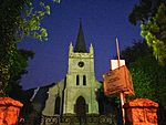 |
| 9/2/018/0028 | Battle of Blaauberg Battlefield, Bloubergstrand, Cape Town District | The Battle of Blaauwberg Battlefield marks a significant event in the region's history and holds significant cultural and historical importance. This battle took place on January 8, 1806, between the British forces under Sir David Baird and the Dutch East India Company's garrison commanded by General Janssens, concluding with a decisive British victory, resulting in the British taking control of the Cape Colony from the Dutch. This event was instrumental in shaping the subsequent history of South Africa, leading to British colonial rule and eventually the establishment of modern Cape Town. Today, the Blaauwberg Battlefield is preserved as a heritage site, commemorating the bravery and sacrifice of those who fought on both sides. | Cape Town | Upload Photo | |||
| 9/2/018/0028/01 | Proposed memorial for the Battle of Blaauberg, Bloubergstrand, Cape | Cape Town | Upload Photo | ||||
| 9/2/018/0033 | The Retreat, 16 Park Avenue, Camps Bay, Cape Town | Type of site: House. | Cape Town, Camps Bay | The Cape | Provisional Protection | 33°57′01″S 18°22′52″E / 33.950266°S 18.381143°E / -33.950266; 18.381143 (SAHRA identifier 9/2/018/0033 - The Retreat, 16 Park Avenue, Camps Bay, Cape Town) | Upload Photo |
| 9/2/018/0035 | MILNERTON MUNICIPAL AREA, GENERAL | Cape Town | Upload Photo | ||||
| 9/2/018/0037 | Woutersen Wessels Vault, Wessels Road, Green Point, Cape Town | A vault with a surrounding wall. It was erected in 1827 by the widow of Peter Woutersen. His granddaughter married Jacobus Christoffel Wessels, whose son, Sir John Wessels, became Chief Justice of South Africa in the 1930s. Various members of the family lived on the Braemar Estate. Because the vault had be[clarification needed] Type of site: Vault. The architecture is most interesting and there is reason to believe that it is the work of the well-known architect Hermann Schutte. | Cape Town, Green Point | The Cape | Provincial Heritage Site | 33°54′44″S 18°24′45″E / 33.912125°S 18.412626°E / -33.912125; 18.412626 (SAHRA identifier 9/2/018/0037 - Woutersen Wessels Vault, Wessels Road, Green Point, Cape Town) | ![A vault with a surrounding wall. It was erected in 1827 by the widow of Peter Woutersen. His granddaughter married Jacobus Christoffel Wessels, whose son, Sir John Wessels, became Chief Justice of South Africa in the 1930s. Various members of the family lived on the Braemar Estate. Because the vault had be[clarification needed] Type of site: Vault. The architecture is most interesting and there is reason to believe that it is the work of the well-known architect Hermann Schutte.](http://upload.wikimedia.org/wikipedia/commons/thumb/9/95/Woutersen-Wessels_Vault.jpg/150px-Woutersen-Wessels_Vault.jpg) |
| 9/2/018/0039 | Dutch Reformed Church, Batavia Road, Bloubergstrand | Built in the traditional Cape Dutch architectural style, the church reflects the cultural heritage of the Dutch settlers who arrived in the Cape Colony in the 17th and 18th centuries. | 33°48′01″S 18°27′34″E / 33.800196°S 18.459420°E / -33.800196; 18.459420 (SAHRA identifier 9/2/018/0039 - Dutch Reformed Church, Batavia Road, Bloubergstrand) | Upload Photo | |||
| 9/2/018/0044 | Brooklyn Fire Station, Koeberg Road, Brooklyn, Cape Town | Cape Town | 33°54′57″S 18°28′50″E / 33.915929°S 18.480681°E / -33.915929; 18.480681 (SAHRA identifier 9/2/018/0044 - Brooklyn Fire Station, Koeberg Road, Brooklyn, Cape Town) | Upload Photo | |||
| 9/2/018/0049 | 18-20 Stadler Road, Bloubergstrand, Cape Town District | Cape Town | 33°48′09″S 18°27′37″E / 33.802416°S 18.460329°E / -33.802416; 18.460329 (SAHRA identifier 9/2/018/0049 - 18-20 Stadler Road, Bloubergstrand, Cape Town District) | Upload Photo | |||
| 9/2/018/0053 | Green Point Lighthouse, Cape Town | This lighthouse, which was built by Hermann Schutte and probably also designed by him, is the oldest structure of its kind in South Africa. Construction work started on 14 September 1821, and the lighthouse was officially opened on 12 April 1824. It origi[clarification needed] Type of site: Lighthouse Current use: Lighthouse. | Cape Town, Green Point | The Cape | Provincial Heritage Site | 33°54′04″S 18°24′02″E / 33.901111°S 18.400555°E / -33.901111; 18.400555 (SAHRA identifier 9/2/018/0053 - Green Point Lighthouse, Cape Town) | ![Main article: Green Point Lighthouse, Cape Town This lighthouse, which was built by Hermann Schutte and probably also designed by him, is the oldest structure of its kind in South Africa. Construction work started on 14 September 1821, and the lighthouse was officially opened on 12 April 1824. It origi[clarification needed] Type of site: Lighthouse Current use: Lighthouse.](http://upload.wikimedia.org/wikipedia/commons/thumb/3/35/Greenpoint_Lighthouse_close-up.jpg/103px-Greenpoint_Lighthouse_close-up.jpg) |
| 9/2/018/0057 | BLOUBERGSTRAND LOCAL AREA, GENERAL | Cape Town | Upload Photo | ||||
| 9/2/018/0062 | Old Wooden Bridge over the Milnerton Lagoon, Milnerton | Type of site: Bridge Current use: Bridge. | Cape Town, Milnerton | The Cape | Provincial Heritage Site | 33°52′53″S 18°29′25″E / 33.881376°S 18.490285°E / -33.881376; 18.490285 (SAHRA identifier 9/2/018/0062 - Old Wooden Bridge over the Milnerton Lagoon, Milnerton) |  |
| 9/2/018/0064 | was Ellerslie Girls' High School and was Tafelberg School, Main Road, Sea Point, Cape Town | Type of site: School Current use: Redevelopment | Cape Town, Sea Point | The Cape | Provincial Heritage Site | 33°54′57″S 18°23′27″E / 33.915907°S 18.390730°E / -33.915907; 18.390730 (SAHRA identifier 9/2/018/0064 - was Ellerslie Girls' High School and was Tafelberg School, Main Road, Sea Point, Cape Town) |  |
| 9/2/018/0067 | 38-46 Queens Road, Bantry Bay, Cape Town | Cape Town | 33°55′28″S 18°22′55″E / 33.924564°S 18.381967°E / -33.924564; 18.381967 (SAHRA identifier 9/2/018/0067 - 38-46 Queens Road, Bantry Bay, Cape Town) | Upload Photo | |||
| 9/2/018/0067/001 | 38 Queens Road, Bantry Bay, Cape Town | Cape Town, Bantry Bay | The Cape | Provincial Heritage Site | 33°55′23″S 18°22′50″E / 33.923038°S 18.380568°E / -33.923038; 18.380568 (SAHRA identifier 9/2/018/0067/001 - 38 Queens Road, Bantry Bay, Cape Town) | Upload Photo | |
| 9/2/018/0067/2 | 40 Queens Road, Bantry Bay, Cape Town | Cape Town | 33°55′28″S 18°22′55″E / 33.924564°S 18.381967°E / -33.924564; 18.381967 (SAHRA identifier 9/2/018/0067/2 - 40 Queens Road, Bantry Bay, Cape Town) | Upload Photo | |||
| 9/2/018/0067/3 | 42 Queens Road, Bantry Bay, Cape Town | Cape Town | 33°55′28″S 18°22′55″E / 33.924564°S 18.381967°E / -33.924564; 18.381967 (SAHRA identifier 9/2/018/0067/3 - 42 Queens Road, Bantry Bay, Cape Town) | Upload Photo | |||
| 9/2/018/0067/4 | 44 Queens Road, Bantry Bay, Cape Town | Cape Town | 33°55′28″S 18°22′55″E / 33.924564°S 18.381967°E / -33.924564; 18.381967 (SAHRA identifier 9/2/018/0067/4 - 44 Queens Road, Bantry Bay, Cape Town) | Upload Photo | |||
| 9/2/018/0067/5 | 46 Queens Road, Bantry Bay, Cape Town | Cape Town | 33°55′28″S 18°22′55″E / 33.924564°S 18.381967°E / -33.924564; 18.381967 (SAHRA identifier 9/2/018/0067/5 - 46 Queens Road, Bantry Bay, Cape Town) | Upload Photo | |||
| 9/2/018/0074/001 | 2 Grove Road, Mowbray, Cape Town | These nine houses form part of a unique block consisting of two terraced rows of identical late Victorian double-storeyed semi-detached houses that date from the 1880s. The first and last houses in Albert Road have ornate triangular pedimented gables with | Cape Town, Mowbray | The Cape | Provincial Heritage Site | 33°56′45″S 18°28′22″E / 33.945919°S 18.472858°E / -33.945919; 18.472858 (SAHRA identifier 9/2/018/0074/001 - 2 Grove Road, Mowbray, Cape Town) |  |
| 9/2/018/0074/002 | 4 Grove Road, Mowbray, Cape Town | These nine houses form part of a unique block consisting of two terraced rows of identical late Victorian double-storeyed semi-detached houses that date from the 1880s. The first and last houses in Albert Road have ornate triangular pedimented gables | Cape Town, Mowbray | The Cape | Provincial Heritage Site | 33°56′45″S 18°28′22″E / 33.945928°S 18.472796°E / -33.945928; 18.472796 (SAHRA identifier 9/2/018/0074/002 - 4 Grove Road, Mowbray, Cape Town) | |
| 9/2/018/0074/003 | 6 Grove Road, Mowbray, Cape Town | These nine houses form part of a unique block consisting of two terraced rows of identical late Victorian double-storeyed semi-detached houses that date from the 1880s. The first and last houses in Albert Road have ornate triangular pedimented gables | Cape Town, Mowbray | The Cape | Provincial Heritage Site | 33°56′45″S 18°28′22″E / 33.945951°S 18.472750°E / -33.945951; 18.472750 (SAHRA identifier 9/2/018/0074/003 - 6 Grove Road, Mowbray, Cape Town) | |
| 9/2/018/0074/004 | 8 Grove Road, Mowbray, Cape Town | Type of site: Terraced House. These nine houses form part of a unique block consisting of two terraced rows of identical late Victorian double-storeyed semi-detached houses that date from the 1880s. The first and last houses in Albert Road have ornate triangular pedimented gables | Cape Town, Mowbray | The Cape | Provincial Heritage Site | 33°56′46″S 18°28′22″E / 33.945973°S 18.472686°E / -33.945973; 18.472686 (SAHRA identifier 9/2/018/0074/004 - 8 Grove Road, Mowbray, Cape Town) | |
| 9/2/018/0074/005 | 10 Grove Road, Mowbray, Cape Town | Type of site: Terraced House. These nine houses form part of a unique block consisting of two terraced rows of identical late Victorian double-storeyed semi-detached houses that date from the 1880s. The first and last houses in Albert Road have ornate triangular pedimented gables | Cape Town, Mowbray | The Cape | Provincial Heritage Site | 33°56′46″S 18°28′21″E / 33.945991°S 18.472612°E / -33.945991; 18.472612 (SAHRA identifier 9/2/018/0074/005 - 10 Grove Road, Mowbray, Cape Town) | |
| 9/2/018/0074/006 | 12 Grove Road, Mowbray, Cape Town | Type of site: Terraced House. These nine houses form part of a unique block consisting of two terraced rows of identical late Victorian double-storeyed semi-detached houses that date from the 1880s. The first and last houses in Albert Road have ornate triangular pedimented gables | Cape Town, Mowbray | The Cape | Provincial Heritage Site | 33°56′46″S 18°28′21″E / 33.946012°S 18.472564°E / -33.946012; 18.472564 (SAHRA identifier 9/2/018/0074/006 - 12 Grove Road, Mowbray, Cape Town) | |
| 9/2/018/0075 | Grove House, 4 Grove Street, Green Point, Cape Town | Grove House in its present form dates from the late nineteenth century. As such it is a good example of Victorian architecture. | Cape Town, Green Point | The Cape | Provincial Heritage Site | 33°54′31″S 18°24′20″E / 33.908505°S 18.405470°E / -33.908505; 18.405470 (SAHRA identifier 9/2/018/0075 - Grove House, 4 Grove Street, Green Point, Cape Town) | 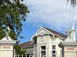 |
| 9/2/018/0076 | St Peter's Cemetery, Main Road, Mowbray, Cape Town | Type of site: Graveyard. | Cape Town, Mowbray | The Cape | Register | 33°56′32″S 18°28′03″E / 33.942299°S 18.467466°E / -33.942299; 18.467466 (SAHRA identifier 9/2/018/0076 - St Peter's Cemetery, Main Road, Mowbray, Cape Town) |  |
| 9/2/018/0077 | Ruth Prowse School of Art, Elson Road, Woodstock, Cape Town | This historic complex of buildings, of which the core of the original dwelling-house dates from the eighteenth century, was built on land originally granted in 1666 to Hendrik Lacus. The group of buildings is at present being used by the Ruth Prowse Art C Type of site: School of Art Previous use: House. Current use: College. | Cape Town, Woodstock | The Cape | Provincial Heritage Site | 33°55′57″S 18°27′17″E / 33.932499°S 18.454860°E / -33.932499; 18.454860 (SAHRA identifier 9/2/018/0077 - Ruth Prowse School of Art, Elson Road, Woodstock, Cape Town) |  |
| 9/2/018/0081 | Mowbray Town Hall, 129 - 130 Main Road, Cape Town | Brick and terracotta This impressive town hall with its Flemish Renaissance features was designed by the architect J. C. Tully of Tully and Waters and erected in 1900. Type of site: Town Hall Previous use: Town hall. | Cape Town, Mowbray | The Cape | Provincial Heritage Site | 33°56′57″S 18°28′16″E / 33.949281°S 18.471082°E / -33.949281; 18.471082 (SAHRA identifier 9/2/018/0081 - Mowbray Town Hall, 129 - 130 Main Road, Cape Town) |  |
| 9/2/018/0083 | 20 Sydney Street, Green Point, Cape Town | Cape Town | 33°54′30″S 18°24′24″E / 33.908408°S 18.406707°E / -33.908408; 18.406707 (SAHRA identifier 9/2/018/0083 - 20 Sydney Street, Green Point, Cape Town) | Upload Photo | |||
| 9/2/018/0084 | SALT RIVER/WOODSTOCK, GENERAL | Salt River was a center for textile manufacturing during the 19th and 20th centuries. Today, it is undergoing urban renewal, with old warehouses being transformed into creative spaces, studios, and residential lofts. Woodstock, adjacent to Salt River, was an industrial hub known for its factories and Victorian-era homes. Today known for its vibrant street art scene, galleries, boutiques, and artisanal coffee shops. | Cape Town | Upload Photo | |||
| 9/2/018/0090 | 22 St John's Street, Sea Point, Cape Town | Cape Town | 33°55′09″S 18°23′22″E / 33.919294°S 18.389563°E / -33.919294; 18.389563 (SAHRA identifier 9/2/018/0090 - 22 St John's Street, Sea Point, Cape Town) | Upload Photo | |||
| 9/2/018/0099 | SA Glass Company, cnr Lower Collingwood Road & Oak Street, Observatory | Cape Town | 33°56′10″S 18°28′17″E / 33.936242°S 18.471265°E / -33.936242; 18.471265 (SAHRA identifier 9/2/018/0099 - SA Glass Company, cnr Lower Collingwood Road & Oak Street, Observatory) | Upload Photo | |||
| 9/2/018/0108 | Ons Huisie, Bloubergstrand, Cape Town | This cottage which for many years was the property of the Stadler family, is a typical example of the simpler form of vernacular architectural style found on the coastal areas of the Western Cape. The periodic additions, the plain side gables and the ove Type of site: House. | Cape Town, Bloubergstrand | The Cape | Provincial Heritage Site | 33°47′58″S 18°27′32″E / 33.799547°S 18.458913°E / -33.799547; 18.458913 (SAHRA identifier 9/2/018/0108 - Ons Huisie, Bloubergstrand, Cape Town) |  |
| 9/2/018/0109 | The New Laboratory, Green Point, Cape Town | Designed as a multi-functional space, The New Laboratory serves as a hub for research, development, and collaboration across various disciplines. It houses laboratories equipped with state-of-the-art technology for scientific exploration and experimentation. The building's architectural features, such as solar panels, efficient lighting systems, and green roofs, underscore its commitment to sustainability and minimizing environmental impact. | Cape Town, Green Point | The Cape | Provincial Heritage Site | 33°54′14″S 18°24′51″E / 33.903990°S 18.414125°E / -33.903990; 18.414125 (SAHRA identifier 9/2/018/0109 - The New Laboratory, Green Point, Cape Town) | Upload Photo |
| 9/2/018/0112 | Glen Country Club, Victoria Road, Clifton | Cape Town | Upload Photo | ||||
| 9/2/018/0116/001 | Zonnebloem Cottages, Cambridge Street, Woodstock, Cape Town | These farm labourer cottages were Victorianised in the early nineteenth century and together with the Zonnebloem College complex form an integral part of an historic area within the City of Cape Town. | Cape Town, Woodstock | The Cape | Provincial Heritage Site | 33°55′31″S 18°25′26″E / 33.925248°S 18.423813°E / -33.925248; 18.423813 (SAHRA identifier 9/2/018/0116/001 - Zonnebloem Cottages, Cambridge Street, Woodstock, Cape Town) | Upload Photo |
| 9/2/018/0129 | ROSEBANK LOCAL AREA GENERAL | Cape Town | Upload Photo | ||||
| 9/2/018/0130 | "Bingley", 105 Victoria Road, Camps Bay, Cape Town | Cape Town | 33°56′54″S 18°22′44″E / 33.948320°S 18.378821°E / -33.948320; 18.378821 (SAHRA identifier 9/2/018/0130 - "Bingley", 105 Victoria Road, Camps Bay, Cape Town) | Upload Photo | |||
| 9/2/018/0136 | St. Mary's Church, Albert Road, Woodstock, Cape Town | Cape Town | 33°55′36″S 18°26′47″E / 33.926751°S 18.446461°E / -33.926751; 18.446461 (SAHRA identifier 9/2/018/0136 - St. Mary's Church, Albert Road, Woodstock, Cape Town) | Upload Photo | |||
| 9/2/018/0147 | Klein Zoar, 4 Wemys Street, Brooklyn, Cape Town | This type of pioneers house according to its structure and architectural features probably dates back to the 18th century and as such is representative of the old vernacular architectural style. According to tradition "Klein Zoar" is the former homestead Type of site: House Current use: House. | Cape Town, Brooklyn | The Cape | Provincial Heritage Site | 33°54′06″S 18°28′59″E / 33.901629°S 18.482991°E / -33.901629; 18.482991 (SAHRA identifier 9/2/018/0147 - Klein Zoar, 4 Wemys Street, Brooklyn, Cape Town) |  |
| 9/2/018/0148 | OBSERVATORY, GENERAL | Cape Town | Upload Photo | ||||
| 9/2/018/0153 | Groote Schuur Hospital, Observatory, Cape Town | Type of site: Hospital. Although the facade of the building is an important example of union architecture, groote Schuur Hospital is best known as a landmark, both physically, and symbolically in terms of world medical history. | Cape Town, Observatory | The Cape | Provincial Heritage Site | 33°56′28″S 18°27′42″E / 33.941038°S 18.461718°E / -33.941038; 18.461718 (SAHRA identifier 9/2/018/0153 - Groote Schuur Hospital, Observatory, Cape Town) | 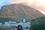 |
| 9/2/018/0155 | Mowbray Hotel, cnr Rhodes Avenue & Main Road, Mowbray | Cape Town | 33°56′59″S 18°28′18″E / 33.949676°S 18.471713°E / -33.949676; 18.471713 (SAHRA identifier 9/2/018/0155 - Mowbray Hotel, cnr Rhodes Avenue & Main Road, Mowbray) | Upload Photo | |||
| 9/2/018/0157 | President Hotel Site, Sea Point, Cape Town | Cape Town | 33°55′25″S 18°22′46″E / 33.923588°S 18.379367°E / -33.923588; 18.379367 (SAHRA identifier 9/2/018/0157 - President Hotel Site, Sea Point, Cape Town) | Upload Photo | |||
| 9/2/018/0164 | Old Military Camp Site, Green Point, Cape Town | A former military installation dating back to the colonial era. | Cape Town | Upload Photo | |||
| 9/2/018/0166 | 1 Bellevue Road, Sea Point, Cape Town | Cape Town | 33°54′54″S 18°23′32″E / 33.915047°S 18.392125°E / -33.915047; 18.392125 (SAHRA identifier 9/2/018/0166 - 1 Bellevue Road, Sea Point, Cape Town) | Upload Photo | |||
| 9/2/018/0167 | SEA POINT LOCAL AREA, GENERAL | Cape Town | Upload Photo | ||||
| 9/2/018/0169 | Vredehoek Tin Mine, Devil's Peak, Cape Town | A historic mining site that reflects the city's early industrial development and mineral exploration. Dating back to the late 19th century, the mine was part of Cape Town's early mining industry, which sought to extract tin and other minerals from the mountains surrounding the city. | Cape Town | Upload Photo | |||
| 9/2/018/0171 | Rietvlei, Milnerton | Cape Town | Upload Photo | ||||
| 9/2/018/0172 | 3 Lincoln Road, Sea Point, Cape Town | Cape Town | 33°54′51″S 18°23′25″E / 33.914273°S 18.390232°E / -33.914273; 18.390232 (SAHRA identifier 9/2/018/0172 - 3 Lincoln Road, Sea Point, Cape Town) | Upload Photo | |||
| 9/2/018/0173 | YMCA, Trill Road, Observatory, Cape Town | Cape Town | 33°56′17″S 18°28′24″E / 33.937932°S 18.473322°E / -33.937932; 18.473322 (SAHRA identifier 9/2/018/0173 - YMCA, Trill Road, Observatory, Cape Town) | Upload Photo | |||
| 9/2/018/0174 | Church of St. Luke the Evangelist, Salt River, Cape Town | Constructed in the late 19th century, the church exemplifies Victorian Gothic Revival style, characterized by pointed arches, stained glass windows, and intricate detailing. | Cape Town | 33°55′46″S 18°27′47″E / 33.929441°S 18.463091°E / -33.929441; 18.463091 (SAHRA identifier 9/2/018/0174 - Church of St. Luke the Evangelist, Salt River, Cape Town) | Upload Photo | ||
| 9/2/018/0176 | Lord Milner Hotel, 37 Milner Road, Woodstock, Cape Town | Cape Town | 33°55′59″S 18°27′12″E / 33.933146°S 18.453372°E / -33.933146; 18.453372 (SAHRA identifier 9/2/018/0176 - Lord Milner Hotel, 37 Milner Road, Woodstock, Cape Town) | Upload Photo | |||
| 9/2/018/0185 | Old Municipal Hall, Jansen Street, Milnerton, Cape Town | This unique hall, which was later known as the Casino, dates from 1904 and was originally erected as a concert and dance hall. In particular, the special sunken dance floor is noteworthy. Type of site: Town Hall. | Cape Town, Milnerton | The Cape | Provincial Heritage Site | 33°53′07″S 18°29′37″E / 33.885230°S 18.493547°E / -33.885230; 18.493547 (SAHRA identifier 9/2/018/0185 - Old Municipal Hall, Jansen Street, Milnerton, Cape Town) |  |
| 9/2/018/0206 | Burial Sites, Somerset Rd Precinct (Prestwich), Green Point, Cape Town | Cape Town | 33°55′03″S 18°25′10″E / 33.917536°S 18.419540°E / -33.917536; 18.419540 (SAHRA identifier 9/2/018/0206 - Burial Sites, Somerset Rd Precinct (Prestwich), Green Point, Cape Town) | Upload Photo | |||
| 9/2/018/0211 | Westoe, Mowbray, Cape Town | Westoe adjoins Coornhoop on its northern side; the land it occupies was a part of the Coornhoop farm. In 1785 the owner of Coornhoop, Helena Jonasse, widow of Claas Coert, bequeathed the old farm jointly to three men. They immediately divided it into three Type of site: House. This property, which came into the possession of Francois Pieter de Necker in 1785, originally formed part of the farm Coornhoop. The Cape Dutch house known as Westoe, which was erected shortly afterwards by De Necker, was restored in 1967. The outbuildin | Cape Town, Mowbray | The Cape | Provincial Heritage Site | 33°56′32″S 18°28′29″E / 33.942194°S 18.474861°E / -33.942194; 18.474861 (SAHRA identifier 9/2/018/0211 - Westoe, Mowbray, Cape Town) | Upload Photo |
| 9/2/018/0212 | Koornhoop dovecot, Dixon Road, Mowbray, Cape Town | Dating back to the 18th century, the dovecot served as a crucial structure for housing pigeons, which provided a reliable source of meat and fertilizer for the early settlers. The Koornhoop dovecot stands as a rare example of Cape Dutch architecture, characterized by its thatched roof and rounded walls punctuated with small pigeonholes. | Cape Town |  | |||
| 9/2/018/0212-001 | Dovecot, Koornhoop, Dixon Road, Mowbray, Cape Town | To the left of the wagon road and five kilometres from the Fort, in what is now called Mowbray Jan van Riebeeck granted land between February, 1657 and February 1658, to fourteen free burghers. He was forced to build a row of little forts or redoubts along Type of site: Dovecote. | Cape Town, Mowbray | The Cape | Provincial Heritage Site | 33°56′36″S 18°28′31″E / 33.943469°S 18.475304°E / -33.943469; 18.475304 (SAHRA identifier 9/2/018/0212-001 - Dovecot, Koornhoop, Dixon Road, Mowbray, Cape Town) | |
| 9/2/018/0218 | Wrensch House, 77 Lower Wrensch Road, Observatory, Cape Town | This is a Georgianised H-shaped Cape—Dutch house. The land it occupies is of unknown origin which was probably added to the Coornhoop farm in 1741. Later in the eighteenth century the land was acquired by C. Rossouw, who purchased the northern part of the .[clarification needed] This building complex, with its Cape-Dutch, Georgian and Victorian features forms a unique architectural unit. The main building as well as some of the outbuildings date from the last quarter of the eighteenth century. | Cape Town, Observatory | The Cape | Provincial Heritage Site | 33°56′23″S 18°28′27″E / 33.939815°S 18.474117°E / -33.939815; 18.474117 (SAHRA identifier 9/2/018/0218 - Wrensch House, 77 Lower Wrensch Road, Observatory, Cape Town) | Upload Photo |
| 9/2/018/0221 | GREEN POINT, CAPE TOWN, GENERAL | Cape Town | Upload Photo | ||||
| 9/2/018/0229 | Treaty Tree, Woodstock, Cape Town | This site and the tree are historically related to the second British occupation of the Cape in 1806. In a building which stood adjacent to this land the capitulation conditions were signed on 10 January 1806, whereby the property of the Batavian Gover in 1803 England who had occupied the Cape Colony for seven years, gave it back to the Netherlands which was then known as the Batavian Republic. General J. W. Janssens was appointed as governor. Barely three years later England again sent a fleet to occupy. Type of site: Tree. In a building which stood adjacent to this land the capitulation conditions were signed on 10 January 1806, whereby the property of the Batavian Government at the Cape was transferred to the commanders of the British forces, Maj-Genl. Sir David Baird a | Cape Town, Woodstock | The Cape | Provincial Heritage Site | 33°55′34″S 18°27′05″E / 33.926247°S 18.451313°E / -33.926247; 18.451313 (SAHRA identifier 9/2/018/0229 - Treaty Tree, Woodstock, Cape Town) |  |
| 9/2/018/0230 | Central Redoubt, Trafalgar Park, Woodstock Cape Town | Cape Town | Upload Photo | ||||
| 9/2/018/0232 | Geological exposure, Sea Point, Cape Town | Below the sea wall at the extreme southern end of Beach Road in Sea Point the rocks show remarkable and unusual geological features. Here one may observe an outstanding example of the contact between dark shales of the Malmesbury Series and Type of site: Geological site or area. | Cape Town, Sea Point | The Cape | Provincial Heritage Site | 33°55′15″S 18°22′43″E / 33.920878°S 18.378628°E / -33.920878; 18.378628 (SAHRA identifier 9/2/018/0232 - Geological exposure, Sea Point, Cape Town) | Upload Photo |
| 9/2/018/0233 | The Glen Country Club, Scenic Reserve, Clifton, Cape Townr | The development and occupation of the steep and rocky inaccessible western coast of the Cape Peninsula took place later and more slowly than the exploitation of the fertile areas of Rondebosch and Wynberg. When, however, this development began, it threat Type of site: Club. | Cape Town, Clifton | The Cape | Provincial Heritage Site | 33°56′37″S 18°22′21″E / 33.943613°S 18.372391°E / -33.943613; 18.372391 (SAHRA identifier 9/2/018/0233 - The Glen Country Club, Scenic Reserve, Clifton, Cape Townr) | Upload Photo |
| 9/2/018/0238 | Earles Dyke Area, The Glen, Camps Bay, Cape Town | Cape Town | Upload Photo | ||||
| 9/2/018/0241 | Molenvliet House, Molenvliet Street, Mowbray, Cape Town | The land on which this house is situated originally formed part of the farm Coornhoop, which was granted to Thielman Hendricks in 1661. The subdivided piece of land was given to Francois Pieter de Necker in 1785. De Necker was presumably the builder of th Type of site: Farmhouse. This property originally formed part of the farm Coornhoop, which was granted to Thieman Hendricks in 1661. The predominantly Cape Dutch house was formerly a barn for the Westoe building complex and dates from the early nineteenth century. | Cape Town, Mowbray | The Cape | Provincial Heritage Site | 33°56′33″S 18°28′31″E / 33.942548°S 18.475239°E / -33.942548; 18.475239 (SAHRA identifier 9/2/018/0241 - Molenvliet House, Molenvliet Street, Mowbray, Cape Town) | Upload Photo |
| 9/2/018/0243/2 | Conservation areas, Lower Gardens, Cape Town | Cape Town | Upload Photo | ||||
| 9/2/018/0243/3 | Conservation areas, Woodstock, Salt River & Walmer Estate, Cape Town | Cape Town | Upload Photo | ||||
| 9/2/018/0243/4 | Conservation areas, Observatory, Cape Town | Cape Town | Upload Photo | ||||
| 9/2/018/0243/5 | Conservation areas, Loader Street, Cape Town | Cape Town | Upload Photo | ||||
| 9/2/018/0243/6 | Conservation areas, Green Point & Sea Point, Cape Town | Cape Town | Upload Photo | ||||
| 9/2/018/0245 | Royal Observatory complex, Observatory, Cape Town | A scientific institution known for its contributions to astronomy and research. Established in the late 19th century, the observatory has played a pivotal role in advancing astronomical knowledge and exploration in Southern Africa. The Royal Observatory complex is renowned for its historical importance and architectural heritage, reflecting the Victorian era's influence on scientific institutions. | Cape Town | National Heritage Site | 33°56′05″S 18°28′38″E / 33.934645°S 18.477210°E / -33.934645; 18.477210 (SAHRA identifier 9/2/018/0245 - Royal Observatory complex, Observatory, Cape Town) |  | |
| 9/2/018/0252 | Dutch Reformed Church, Regent Square, Woodstock, Cape Town | An historically significant religious edifice that embodies the architectural and cultural heritage of the area. Constructed in the 19th century, the church exemplifies Neo-Gothic design, characterized by its pointed arches, intricate stonework, and towering spire. | Cape Town | 33°55′42″S 18°27′04″E / 33.928303°S 18.451230°E / -33.928303; 18.451230 (SAHRA identifier 9/2/018/0252 - Dutch Reformed Church, Regent Square, Woodstock, Cape Town) | Upload Photo | ||
| 9/2/018/0254 | MOUILLE POINT LOCAL AREA, GENERAL | Cape Town | Upload Photo | ||||
| 9/2/018/0256 | 5-7 Bellevue Road, Sea Point, Cape Town | Cape Town | 33°54′54″S 18°23′32″E / 33.915082°S 18.392096°E / -33.915082; 18.392096 (SAHRA identifier 9/2/018/0256 - 5-7 Bellevue Road, Sea Point, Cape Town) | Upload Photo | |||
| 9/2/018/0256/001 | Salisbury House, 5 Bellevue Road, Sea Point, Cape Town | An architectural landmark that exemplifies the Art Deco style prevalent in the early 20th century. Built during a period of urban growth and architectural innovation, the building is characterized by its streamlined forms, geometric motifs, and decorative elements that reflect the era's modernist aesthetics. Situated in Sea Point, a vibrant coastal suburb known for its scenic promenade and cosmopolitan atmosphere, Salisbury House has served various purposes over the years, including residential apartments and commercial spaces. | Cape Town, Sea Point | The Cape | Provincial Heritage Site | 33°54′55″S 18°23′33″E / 33.915302°S 18.392541°E / -33.915302; 18.392541 (SAHRA identifier 9/2/018/0256/001 - Salisbury House, 5 Bellevue Road, Sea Point, Cape Town) | Upload Photo |
| 9/2/018/0256/2 | 7 Bellevue Road, Sea Point, Cape Town | Cape Town | 33°54′54″S 18°23′32″E / 33.915103°S 18.392218°E / -33.915103; 18.392218 (SAHRA identifier 9/2/018/0256/2 - 7 Bellevue Road, Sea Point, Cape Town) | Upload Photo | |||
| 9/2/018/0257 | Camp Site of Survivors of the Haarlem, 1647, Milnerton | Dating back to 1647, the campsite holds historical significance as a testament to early Dutch maritime exploration and survival in South Africa. The survivors' campsite serves as a poignant reminder of the challenges faced by early European explorers in unfamiliar and often harsh environments. It commemorates their resilience and resourcefulness in adapting to new surroundings, forging relationships with local inhabitants, and ultimately laying the groundwork for future Dutch settlement in the Cape Colony. | Cape Town |  | |||
| 9/2/018/0259 | Congregational Church, Sea Point, Cape Town | Built in the late 19th century, the church stands as a testament to Cape Town's Victorian architectural heritage, a Gothic Revival style, and the presence of Congregationalist traditions in the region. The Congregational Church has been a place of worship, fellowship, and community engagement for generations. | Cape Town | 33°54′50″S 18°23′27″E / 33.913920°S 18.390799°E / -33.913920; 18.390799 (SAHRA identifier 9/2/018/0259 - Congregational Church, Sea Point, Cape Town) | Upload Photo | ||
| 9/2/018/0260 | Culemborg-Black River Site, Cape Town | Initially named Culemborg after a Dutch settlement, the area later became integral to Cape Town's industrial growth and maritime trade. The Culemborg-Black River Site represents a convergence of historical layers, including its role in the slave trade, industrialization, and urban planning. Over time, it transformed into a hub for shipping, manufacturing, and urban infrastructure. | Cape Town | Upload Photo | |||
| 9/2/018/0261 | MOWBRAY, CAPE TOWN, GENERAL | Cape Town | Upload Photo | ||||
| 9/2/018/0264/04 | 87 Chiappini Street, Bo-Kaap, Cape Town | Bo-Kaap, known for its colorful houses and cobblestone streets, is one of Cape Town's oldest residential areas, originally settled by Muslim communities in the 18th century. The house features Cape Dutch and Georgian architectural styles, characterized by flat roofs, gabled facades, and sash windows. | Cape Town | 33°55′09″S 18°24′58″E / 33.919237°S 18.416165°E / -33.919237; 18.416165 (SAHRA identifier 9/2/018/0264/04 - 87 Chiappini Street, Bo-Kaap, Cape Town) |  | ||
| 9/2/018/0265 | Tana Baru Muslim Burial Ground, Longmarket Street, Bo-Kaap, Cape Town | Cape Town | Upload Photo | ||||
| 9/2/018/0269 | Oude Molen Building, Valkenberg Hospital, Observatory | A historically significant structure that has served various roles in mental health care and community welfare since its establishment. Dating back to the early 20th century, the building exemplifies Cape Dutch architectural influences, characterized by its gabled roofs, whitewashed walls, and surrounding gardens. | Cape Town | 33°56′15″S 18°28′48″E / 33.937589°S 18.479995°E / -33.937589; 18.479995 (SAHRA identifier 9/2/018/0269 - Oude Molen Building, Valkenberg Hospital, Observatory) | Upload Photo | ||
| 9/2/018/0270 | St James the Great Church, 12 St James Road, Sea Point, Cape Town | Constructed in the late 19th century, the church embodies Gothic Revival architecture, characterized by its pointed arches, stained glass windows, and lofty spire. St James the Great Church has served as a place of worship, community fellowship, and spiritual guidance for generations. Beyond its religious functions, the church holds cultural importance as a center for social outreach, charitable activities, and cultural events. | Cape Town | 33°54′36″S 18°23′37″E / 33.909996°S 18.393569°E / -33.909996; 18.393569 (SAHRA identifier 9/2/018/0270 - St James the Great Church, 12 St James Road, Sea Point, Cape Town) | Upload Photo | ||
| 9/2/018/0272 | LLUNDUDNO LOCAL AREA, GENERAL | Cape Town | Upload Photo | ||||
| 9/2/018/0273 | 1-11 Albert Road, Mowbray, Cape Town District | Cape Town | 33°56′44″S 18°28′21″E / 33.945694°S 18.472546°E / -33.945694; 18.472546 (SAHRA identifier 9/2/018/0273 - 1-11 Albert Road, Mowbray, Cape Town District) |  | |||
| 9/2/018/0273/001 | 1 Albert Road, Mowbray, Cape Town | These nine houses form part of a unique block consisting of two terraced rows of identical late Victorian double-storeyed semi-detached houses that date from the 1880s. The first and last houses in Albert Road have ornate triangular pedimented gables with This property forms part of two rows of double-storeyed Victorian terrace houses which stand back to back on a block shared by the Mowbray Presbyterian Church. Each row consists of six units which are semi-detached. Besides slight variations in the filigr[clarification needed] | Cape Town, Mowbray | The Cape | Provincial Heritage Site | 33°56′44″S 18°28′22″E / 33.945634°S 18.472726°E / -33.945634; 18.472726 (SAHRA identifier 9/2/018/0273/001 - 1 Albert Road, Mowbray, Cape Town) | |
| 9/2/018/0273/002 | 3 Albert Road, Mowbray, Cape Town | This property forms part of a unique block consisting of two terraced rows of identical late Victorian double-storey semi-detached houses that date from the 1880s. The first and last houses in Albert Road have ornate triangular pedimented gables with cart This property forms part of two rows of double-storeyed Victorian terrace houses which stand back to back on a block shared by the Mowbray Presbyterian Church. Each row consists of six units which are semi-detached. Besides slight variations in the filigr Type of site: Terraced House. | Cape Town, Mowbray | The Cape | Provincial Heritage Site | 33°56′44″S 18°28′22″E / 33.9456555555°S 18.4726611111°E / -33.9456555555; 18.4726611111 (SAHRA identifier 9/2/018/0273/002 - 3 Albert Road, Mowbray, Cape Town) | |
| 9/2/018/0273/003 | 5 Albert Road, Mowbray, Cape Town | This property forms part of a unique block consisting of two terraced rows of identical late Victorian double-storey semi-detached houses that date from the 1880s. The first and last houses in Albert Road have ornate triangular pedimented gables with cart This property forms part of two rows of double-storeyed Victorian terrace houses which stand back to back on a block shared by the Mowbray Presbyterian Church. Each row consists of six units which are semi-detached. Besides slight variations in the filigr Type of site: Terraced House. | Cape Town, Mowbray | The Cape | Provincial Heritage Site | 33°56′44″S 18°28′21″E / 33.945675°S 18.4726°E / -33.945675; 18.4726 (SAHRA identifier 9/2/018/0273/003 - 5 Albert Road, Mowbray, Cape Town) | |
| 9/2/018/0273/004 | 7 Albert Road, Mowbray, Cape Town | This property forms part of a unique block consisting of two terraced rows of identical late Victorian double-storey semi-detached houses that date from the 1880s. The first and last houses in Albert Road have ornate triangular pedimented gables with cart This property forms part of two rows of double-storeyed Victorian terrace houses which stand back to back on a block shared by the Mowbray Presbyterian Church. Each row consists of six units which are semi-detached. Besides slight variations in the filigr Type of site: Terraced House. | Cape Town, Mowbray | The Cape | Provincial Heritage Site | 33°56′44″S 18°28′21″E / 33.9456944444°S 18.4725472222°E / -33.9456944444; 18.4725472222 (SAHRA identifier 9/2/018/0273/004 - 7 Albert Road, Mowbray, Cape Town) | |
| 9/2/018/0273/005 | 9 Albert Road, Mowbray, Cape Town | This property forms part of a unique block consisting of two terraced rows of identical late Victorian double-storey semi-detached houses that date from the 1880s. The first and last houses in Albert Road have ornate triangular pedimented gables with cart This property forms part of two rows of double-storeyed Victorian terrace houses which stand back to back on a block shared by the Mowbray Presbyterian Church. Each row consists of six units which are semi-detached. Besides slight variations in the filigr Type of site: Terraced House. | Cape Town, Mowbray | The Cape | Provincial Heritage Site | 33°56′45″S 18°28′21″E / 33.9457194444°S 18.4724861111°E / -33.9457194444; 18.4724861111 (SAHRA identifier 9/2/018/0273/005 - 9 Albert Road, Mowbray, Cape Town) | |
| 9/2/018/0273/006 | 11 Albert Road, Mowbray, Cape Town | These nine houses form part of a unique block consisting of two terraced rows of identical late Victorian double-storeyed semi-detached houses that date from the 1880s. The first and last houses in Albert Road have ornate triangular pedimented gables wi This property forms part of two rows of double-storeyed Victorian terrace houses which stand back to back on a block shared by the Mowbray Presbyterian Church. Each row consists of six units which are semi-detached. Besides slight variations in the filigr[clarification needed] | Cape Town, Mowbray | The Cape | Provincial Heritage Site | 33°56′45″S 18°28′21″E / 33.945734°S 18.472420°E / -33.945734; 18.472420 (SAHRA identifier 9/2/018/0273/006 - 11 Albert Road, Mowbray, Cape Town) | |
| 9/2/018/0276 | 3 Long Street, Mowbray, Cape Town | Cape Town | 33°56′51″S 18°28′25″E / 33.947474°S 18.473507°E / -33.947474; 18.473507 (SAHRA identifier 9/2/018/0276 - 3 Long Street, Mowbray, Cape Town) | Upload Photo | |||
| 9/2/018/0278 | MAITLAND LOCAL AREA, GENERAL | Cape Town | Upload Photo | ||||
| 9/2/018/0278/1 | Erf 154483, Garden Village Primary, Maitland, Cape Town | Cape Town | 33°56′02″S 18°29′08″E / 33.933888°S 18.485649°E / -33.933888; 18.485649 (SAHRA identifier 9/2/018/0278/1 - Erf 154483, Garden Village Primary, Maitland, Cape Town) | Upload Photo | |||
| 9/2/018/0279 | Alexandra Institute, Maitland cape Town | Cape Town | Upload Photo | ||||
| 9/2/018/0279/001 | De Nieuwe Molen, Alexandra Institute, Maitland, Cape Town | The Nieuwe Molen, with its bullet-shaped tower, was erected in the years 1780-1782. In 1928 it was converted into a church and at present it serves as a music room for the Alexandra Institute. 10/2/584. Type of site: Industrial Previous use: Mill. | Cape Town, Maitland | The Cape | Provincial Heritage Site | 33°55′57″S 18°28′56″E / 33.932557°S 18.482342°E / -33.932557; 18.482342 (SAHRA identifier 9/2/018/0279/001 - De Nieuwe Molen, Alexandra Institute, Maitland, Cape Town) | 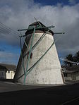 |
| 9/2/018/0280 | Maitland Cemetery, Voortekker Road, Maitland, Cape Town District | Cape Town | 33°55′06″S 18°31′19″E / 33.918435°S 18.521831°E / -33.918435; 18.521831 (SAHRA identifier 9/2/018/0280 - Maitland Cemetery, Voortekker Road, Maitland, Cape Town District) | Upload Photo | |||
| 9/2/018/0280/1 | Garden of Remembrance, Maitland Cemetery | The Garden of Remembrance is a space dedicated to honoring the deceased. Established as part of Maitland Cemetery, it features landscaped gardens and memorial plaques, providing a serene setting for reflection and remembrance. This site serves as a poignant reminder of Cape Town's multicultural heritage and offers a dignified final resting place for individuals from various backgrounds within the community. | Cape Town | Upload Photo | |||
| 9/2/018/0280/2 | Memorial to Slave Burial Site, Maitland Cemetery | A tribute to the historical significance of enslaved individuals in South Africa. Located within Maitland Cemetery, this memorial honors those who were buried in unmarked graves during the colonial era, acknowledging their contributions and enduring legacy. | Cape Town | Upload Photo | |||
| 9/2/018/0281 | Mile Stone 1V, 282 Voortrekker Road, Maitland, Cape Town | Cape Town | 33°55′24″S 18°29′20″E / 33.923214°S 18.488988°E / -33.923214; 18.488988 (SAHRA identifier 9/2/018/0281 - Mile Stone 1V, 282 Voortrekker Road, Maitland, Cape Town) | Upload Photo | |||
| 9/2/018/0283 | CLIFTON LOCAL AREA, GENERAL | Cape Town | Upload Photo | ||||
| 9/2/018/0284 | Dutch Reformed Church, Main Road, Maitland | Cape Town | 33°55′25″S 18°29′07″E / 33.923532°S 18.485278°E / -33.923532; 18.485278 (SAHRA identifier 9/2/018/0284 - Dutch Reformed Church, Main Road, Maitland) | Upload Photo | |||
| 9/2/018/0286 | CAMPS BAY LOCAL AREA, GENERAL | Cape Town | Upload Photo | ||||
| 9/2/018/0290 | Trafalgar Park, cnr Searle St & Victoria Rd, Woodstock | Originally established during Cape Town's colonial era, Trafalgar Park has evolved into a popular community hub featuring playgrounds, sports fields, and picnic areas. | Cape Town | 33°55′40″S 18°26′27″E / 33.927895°S 18.440901°E / -33.927895; 18.440901 (SAHRA identifier 9/2/018/0290 - Trafalgar Park, cnr Searle St & Victoria Rd, Woodstock) |  | ||
| 9/2/018/0290/001 | Central Redoubt, Trafalgar Park, Woodstock, Cape Town | This fortress was hastily built in 1781, when an attack by British forces on the Cape was expected. A conical kiln, probably for making bricks, was added some 50 years later. From the beginning of the settlement at the Cape, the commanders were concerned Type of site: Fort. This fortress was hastily built in 1781, when an attack by British forces on the Cape was expected. A conical kiln, probably for making bricks, was added some 50 years later. | Cape Town, Woodstock | The Cape | Provincial Heritage Site | 33°55′47″S 18°26′30″E / 33.929808°S 18.441631°E / -33.929808; 18.441631 (SAHRA identifier 9/2/018/0290/001 - Central Redoubt, Trafalgar Park, Woodstock, Cape Town) |  |
| 9/2/018/0295 | BANTRY BAY LOCAL | Cape Town | Upload Photo | ||||
| 9/2/018/0296 | MELKBOSSTRAND LOCAL AREA | Cape Town | Upload Photo | ||||
| 9/2/018/0298 | The Homestead ("Casa Felicia"), 60 Llandudno Road, Llandudno | Also known as "Casa Felicia," situated at 60 Llandudno Road in Llandudno, Cape Town. | Cape Town | Register (Pending) | 34°00′29″S 18°20′37″E / 34.007948°S 18.343594°E / -34.007948; 18.343594 (SAHRA identifier 9/2/018/0298 - The Homestead ("Casa Felicia"), 60 Llandudno Road, Llandudno) | Upload Photo | |
| 9/2/018/0299 | The South African Astronomical Observatory, Mowbray | Cape Town | 33°56′04″S 18°28′38″E / 33.934554°S 18.477103°E / -33.934554; 18.477103 (SAHRA identifier 9/2/018/0299 - The South African Astronomical Observatory, Mowbray) |  | |||
| 9/2/108/0010/12 | Bungalow 66, Clifton, Cape Town | Clifton | Cape Town | Upload Photo | |||
| HM\CAPE TOWN METRO\NEWLANDS \DE HEL FOREST | De Hel Forest | Cape Town | The Cape | Provincial Heritage Site | 34°00′46″S 18°25′13″E / 34.01271°S 18.42015°E / -34.01271; 18.42015 (SAHRA identifier HM\CAPE TOWN METRO\NEWLANDS \DE HEL FOREST - De Hel Forest) |  | |
| HM\CAPE TOWN METRO\SALT RIVER \COMMUNITY HOUSE | Community House | Cape Town, Salt River | The Cape | Provincial Heritage Site | 33°55′48″S 18°27′27″E / 33.929998°S 18.4576°E / -33.929998; 18.4576 (SAHRA identifier HM\CAPE TOWN METRO\SALT RIVER \COMMUNITY HOUSE - Community House) |  | |
| 9/2/018/0129-008 | Rex Trueform Factory Complex | Cape Town, Salt River | The Cape | Provincial Heritage Site | 33°55′58″S 18°27′31″E / 33.932866°S 18.458619°E / -33.932866; 18.458619 (SAHRA identifier 9/2/018/0129-008 - Rex Trueform Factory Complex) |  |
References
- ^ South African Heritage Resource Agency SARHA – Gazetted Sites database Archived 31 December 2008 at the Wayback Machine, retrieved 8 October 2012
- ^ Heritage Western Cape
Wikimedia Commons has media related to Cultural heritage monuments in Cape Town.
- v
- t
- e
Lists of South African Heritage Resources
| Eastern Cape | |
|---|---|
| Free State | |
| Gauteng | |
| KwaZulu-Natal | |
| Limpopo | |
| Mpumalanga | |
| North West | |
| Northern Cape | |
| Western Cape |


