List of airports in the Bahamas
This is a list of airports in the Bahamas, grouped by island and sorted by location.
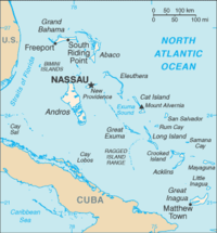
The Bahamas, officially the Commonwealth of The Bahamas, is an English-speaking country consisting of 29 islands, 661 cays, and 2,387 islets. It is located at the north-east of the Caribbean Sea in the Atlantic Ocean north of Cuba, Hispaniola (Dominican Republic and Haiti) and the Caribbean Sea, northwest of the Turks and Caicos Islands, and southeast of the United States of America (nearest to the state of Florida). Its total land area is almost 14,000 square kilometres (5,400 sq mi), with an estimated population of 330,000. Its capital is Nassau.
Map all coordinates using OpenStreetMap
Download coordinates as:
- KML
- GPX (all coordinates)
- GPX (primary coordinates)
- GPX (secondary coordinates)
Airports
Airport names shown in bold indicate the airport has scheduled service on commercial airlines.
| Location served | ICAO | IATA | Airport name | Runway (ft) | Coordinates |
|---|---|---|---|---|---|
| ABACO | |||||
| Castaway Cay | MYAG | Castaway Cay Airport (private) | 14/32: 3,100 x 80, ASPHALT | 26°05′26.0″N 077°32′23.9″W / 26.090556°N 77.539972°W / 26.090556; -77.539972 (Castaway Cay Airport (Castaway Cay)) | |
| Marsh Harbour | MYAM | MHH | Marsh Harbour Airport | 6,100 x 100[1] | 26°30′41.1″N 077°05′00.7″W / 26.511417°N 77.083528°W / 26.511417; -77.083528 (Marsh Harbour International Airport (Marsh Harbour)) |
| Moore's Island | MYAO | Mores Island Airport | 2,640 x 100 | 26°19′04.5″N 077°33′44.3″W / 26.317917°N 77.562306°W / 26.317917; -77.562306 (Hard Bargain Airport (Mores Island)) | |
| Sandy Point | MYAS | Sandy Point Airport | 4,500 x 100 | 26°00′17.0″N 077°23′43.9″W / 26.004722°N 77.395528°W / 26.004722; -77.395528 (Sandy Point Airport (Sandy Point)) | |
| Scotland Cay | MYXI | Scotland Cay Airport (private) | 13/31: 3,000 x 100, GRAVEL | 26°38′31.0″N 077°04′02.9″W / 26.641944°N 77.067472°W / 26.641944; -77.067472 (Scotland Cay Airport (Scotland Cay)) | |
| Spanish Cay | MYAX | Spanish Cay Airport | 14/32: 4,402 x 70, GRAVEL | 26°57′01.2″N 077°32′37.7″W / 26.950333°N 77.543806°W / 26.950333; -77.543806 (Spanish Cay Airport (Spanish Cay)) | |
| Treasure Cay | MYAT | TCB | Treasure Cay Airport | 6,900 x 150 | 26°44′43.2″N 077°23′27.6″W / 26.745333°N 77.391000°W / 26.745333; -77.391000 (Treasure Cay Airport (Treasure Cay)) |
| Walker's Cay | MYAW | WKR | Walker's Cay Airport | 09/27: 2,500 x 80, GRAVEL | 27°15′37.5″N 078°24′08.0″W / 27.260417°N 78.402222°W / 27.260417; -78.402222 (Walker's Cay Airport (Walker's Cay)) |
| ACKLINS | |||||
| Spring Point | MYAP | AXP | Spring Point Airport | 5,000 x 150 | 22°26′30.8″N 073°58′14.9″W / 22.441889°N 73.970806°W / 22.441889; -73.970806 (Spring Point Airport (Spring Point)) |
| ANDROS | |||||
| Andros Town, North Andros | MYAF | ASD | Andros Town Airport (Fresh Creek Airport) | 4,000 x 100 | 24°41′52.7″N 077°47′44.4″W / 24.697972°N 77.795667°W / 24.697972; -77.795667 (Fresh Creek Airport (Fresh Creek)) |
| Andros Town, North Andros | MYCZ | Autec Heliport | H1: 100 x 100, ASPHALT H2: 100 x 100, ASPHALT H3: 100 x 100, ASPHALT H4: 100 x 100, ASPHALT | 24°42′34.2″N 077°46′21.5″W / 24.709500°N 77.772639°W / 24.709500; -77.772639 (Autec Heliport (Andros Town)) | |
| Andros Town, North Andros | Andros Central Airport (closed) | 5,000 x 150 | 24°43′32.8″N 077°59′17.4″W / 24.725778°N 77.988167°W / 24.725778; -77.988167 (Twin Lakes Airport (Andros Central)) | ||
| Congo Town, South Andros | MYAK | TZN[2] | South Andros Airport (Congo Town Airport) | 4,300 x 100 | 24°09′31.5″N 077°35′23.4″W / 24.158750°N 77.589833°W / 24.158750; -77.589833 (Congo Town Airport (Congo Town)) |
| Mangrove Cay | MYAB | MAY | Clarence A. Bain Airport | 5,000 x 75 | 24°17′15.6″N 077°41′03.9″W / 24.287667°N 77.684417°W / 24.287667; -77.684417 (Clarence A Bain Airport (Mangrove Cay)) |
| Nicholls Town, North Andros | MYAN | SAQ | San Andros Airport | 5,000 x 75 | 25°03′13.8″N 078°02′57.4″W / 25.053833°N 78.049278°W / 25.053833; -78.049278 (San Andros Airport (Nicholls Town)) |
| BERRY ISLANDS | |||||
| Big Whale Cay | MYBW | Big Whale Cay Airport | 07/25: 4,000 x 55, ASPHALT | 25°24′07.2″N 077°47′18.3″W / 25.402000°N 77.788417°W / 25.402000; -77.788417 (Big Whale Cay Airport (Big Whale Cay)) | |
| Chub Cay | MYBC | CCZ | Chub Cay International Airport | 11/29: 5,000 x 78, ASPHALT | 25°25′01.8″N 077°52′50.5″W / 25.417167°N 77.880694°W / 25.417167; -77.880694 (Chub Cay International Airport (Chub Cay)) |
| Cistern Cay | MYBT | Cistern Field | 16/34: 2,250 x 80, ASPHALT | 25°46′46.8″N 077°53′08.2″W / 25.779667°N 77.885611°W / 25.779667; -77.885611 (Cistern Field (Cistern Cay)) | |
| Great Harbour Cay | MYBG | GHC | Great Harbour Cay Airport | 4,536 x 80 | 25°44′18.2″N 077°50′25.0″W / 25.738389°N 77.840278°W / 25.738389; -77.840278 (Great Harbour Cay Airport (Bullocks Harbour)) |
| Little Whale Cay | MYBX | Little Whale Cay Airport | 08/26: 1,750 x 52, ASPHALT | 25°26′58.5″N 077°45′34.2″W / 25.449583°N 77.759500°W / 25.449583; -77.759500 (Little Whale Cay Berry Islands Airport (Little Whale Cay)) | |
| BIMINI | |||||
| Bimini | NSB[2] | North Seaplane Base | |||
| Bimini | MYBS | BIM | South Bimini Airport | 5,600 x 100 | 25°41′59.9″N 079°15′54.8″W / 25.699972°N 79.265222°W / 25.699972; -79.265222 (South Bimini Airport (North Bimini)) |
| North Cat Cay | MYCC | CXY | Cat Cay Airport | 13/31: 1,100 x 50, ASPHALT | 25°33′19.0″N 079°16′33.8″W / 25.555278°N 79.276056°W / 25.555278; -79.276056 (Cat Cay Airport (Cat Cay)) |
| Ocean Cay | MYBO | Ocean Cay Airport | 09/27: 1,650 x 92, GRAVEL 17/35: 1,890 x 89, GRAVEL | 25°25′22.5″N 079°12′34.1″W / 25.422917°N 79.209472°W / 25.422917; -79.209472 (Ocean Cay Airport (Ocean Cay)) | |
| CAT ISLAND | |||||
| Arthur's Town | MYCA | ATC | Arthur's Town Airport | 7,034 x 150 | 24°37′46.9″N 075°40′27.9″W / 24.629694°N 75.674417°W / 24.629694; -75.674417 (Arthurs Town Airport (Arthurs Town)) |
| Cutlass Bay | MYCX | Cutlass Bay Airport | 11/29: 2,400 x 60, ASPHALT | 24°08′56.9″N 075°23′53.0″W / 24.149139°N 75.398056°W / 24.149139; -75.398056 (Cutlass Bay Airport (Cutlass Bay)) | |
| Hawks Nest | MYCH | Hawks Nest Airport | 08/26: 4,600 x 80, ASPHALT | 24°09′15.1″N 075°31′13.0″W / 24.154194°N 75.520278°W / 24.154194; -75.520278 (Hawk's Nest Creek Airport (Hawk's Nest Creek)) | |
| New Bight | MYCB | TBI[2] | New Bight Airport | 5,065 x 75 | 24°18′55.1″N 075°27′09.2″W / 24.315306°N 75.452556°W / 24.315306; -75.452556 (New Bight Airport (New Bight)) |
| CAY SAL | |||||
| Cay Sal | MYCS | Cay Sal Airport (private) | 2,000 x 100 | 23°41′34.0″N 080°23′15.0″W / 23.692778°N 80.387500°W / 23.692778; -80.387500 (Cay Sal Airport (Cay Sal)) | |
| CROOKED ISLAND | |||||
| Colonel Hill | MYCI | CRI | Colonel Hill Airport (Crooked Island Airport) | 3,500 x 60 | 22°44′43.4″N 074°10′57.0″W / 22.745389°N 74.182500°W / 22.745389; -74.182500 (Colonel Hill Airport (Colonel Hill)) |
| Pitts Town | MYCP | PWN | Pitts Town Airport | 09/27: 1,960 x 33, ASPHALT | 22°49′47.0″N 074°20′47.1″W / 22.829722°N 74.346417°W / 22.829722; -74.346417 (Pitts Town Point Airport (Pitts Town Point)) |
| ELEUTHERA | |||||
| Freetown | MYEC | Cape Eleuthera Airport (closed) | 11/29: 6,460 x 144, ASPHALT | 24°47′25.2″N 076°17′40.8″W / 24.790333°N 76.294667°W / 24.790333; -76.294667 (Cape Eleuthera Airport (Cape Eleuthera)) | |
| Governor's Harbour | MYEM | GHB | Governor's Harbour Airport | 8,500 x 150 | 25°17′04.9″N 076°19′51.5″W / 25.284694°N 76.330972°W / 25.284694; -76.330972 (Governors Harbour Airport (Governors Harbour)) |
| North Eleuthera | MYEH | ELH | North Eleuthera Airport | 4,500 x 100 | 25°28′32.2″N 076°40′52.8″W / 25.475611°N 76.681333°W / 25.475611; -76.681333 (North Eleuthera Airport (North Eleuthera)) |
| Rock Sound | MYER | RSD | Rock Sound International Airport | 7,200 x 150 | 24°53′42.1″N 076°10′34.6″W / 24.895028°N 76.176278°W / 24.895028; -76.176278 (Rock Sound Airport (Rock Sound)) |
| EXUMA | |||||
| Black Point | MYEB | Black Point Airport | 12/30: 2,620 x 80, ASPHALT | 24°05′21.4″N 076°23′52.5″W / 24.089278°N 76.397917°W / 24.089278; -76.397917 (Blackpoint Airport (Blackpoint)) | |
| Darby Island | Darby Island Airport (private) | 1,500 x 100 | 23°51′04.4″N 076°13′41.1″W / 23.851222°N 76.228083°W / 23.851222; -76.228083 (Darby Island Airport (Darby Island)) | ||
| Fowl Cay | MYXA | Fowl Cay Airport | 10/28: 1,040 x 45, ASPHALT | 24°16′14.6″N 076°32′27.5″W / 24.270722°N 76.540972°W / 24.270722; -76.540972 (Fowl Cay Airport (Fowl Cay)) | |
| Great Exuma Island (George Town) | MYEG | George Town Airport | 11/29: 5,000 x 90, ASPHALT | 23°27′59.6″N 075°46′54.2″W / 23.466556°N 75.781722°W / 23.466556; -75.781722 (George Town Airport (George Town)) | |
| Great Exuma Island (Moss Town) | MYEF | GGT | Exuma International Airport | 8,000 x 100 | 23°33′45.0″N 075°52′39.2″W / 23.562500°N 75.877556°W / 23.562500; -75.877556 (Exuma International Airport (George Town)) |
| Leaf Cay | MYXD | Leaf Cay Airport | 09/27: 1,200 x 40, GRAVEL | 24°08′57.9″N 076°28′22.5″W / 24.149417°N 76.472917°W / 24.149417; -76.472917 (Leaf Cay Airport (Leaf Cay)) | |
| Lee Stocking Island | MYXE/MYEL | Lee Stocking Airport | 12/30: 3,230 x 141, ASPHALT | 23°46′32.1″N 076°06′13.4″W / 23.775583°N 76.103722°W / 23.775583; -76.103722 (Lee Stocking Airport (Lee Stocking)) | |
| Little Darby Island | MYXF | Little Darby Island Airport (private) | 14/32: 1,000 x 75, GRASS | 23°51′28.5″N 076°13′22.5″W / 23.857917°N 76.222917°W / 23.857917; -76.222917 (Little Darby Island Airport (Little Darby Island)) | |
| Little Farmer's Cay | Farmers Cay Airport | 18/36: 2,480 x 56, ASPHALT | 23°57′41.9″N 076°19′34.3″W / 23.961639°N 76.326194°W / 23.961639; -76.326194 (Farmer's Cay Airport (Farmer's Cay)) | ||
| Norman's Cay | MYEN | NMC | Norman's Cay Airport | 3,360 x 70 | 24°35′39.5″N 076°49′12.3″W / 24.594306°N 76.820083°W / 24.594306; -76.820083 (Norman's Cay Airport (Norman's Cay)) |
| Rudder Cut Cay | Rudder Cut Cay Airport | 09/27: 2,150 x 89, GRAVEL | 23°53′11.1″N 076°15′10.2″W / 23.886417°N 76.252833°W / 23.886417; -76.252833 (Rudder Cut Cay Airport (Rudder Cut Cay)) | ||
| Sampson Cay | MYXH | Sampson Cay Airport (private) | 14/32: 2,000 x 39, GRAVEL | 24°12′58.6″N 076°28′42.9″W / 24.216278°N 76.478583°W / 24.216278; -76.478583 (Big Sampson Cay Airport (Big Sampson Cay)) | |
| Staniel Cay | MYES | TYM | Staniel Cay Airport | 3,030 x 75 | 24°10′10.8″N 076°26′21.4″W / 24.169667°N 76.439278°W / 24.169667; -76.439278 (Staniel Cay Airport (Staniel Cay)) |
| Torch Cay | MYTC | TCV | Torch Cay Airport | 12/30: 6,000 x 100, ASPHALT | 23°23′50.7″N 075°29′49.5″W / 23.397417°N 75.497083°W / 23.397417; -75.497083 (Torch Cay Exuma Airport (Torch Cay)) |
| GRAND BAHAMA | |||||
| Deep Water Cay | MYGD | Deep Water Cay Airport | 14/32: 4,200 x 40, GRAVEL | 26°37′57.1″N 077°55′19.1″W / 26.632528°N 77.921972°W / 26.632528; -77.921972 (Deep Water Cay Airport (Deep Water Cay)) | |
| Freeport | MYGF | FPO | Grand Bahama International Airport (Freeport Int'l) | 11,000 x 150 | 26°33′31.6″N 078°41′43.6″W / 26.558778°N 78.695444°W / 26.558778; -78.695444 (Grand Bahama International Airport (Freeport)) |
| High Rock | MYGM | Grand Bahama Aux AF Airport | 05/23: 7,160 x 197, ASPHALT | 26°37′54.6″N 078°21′35.4″W / 26.631833°N 78.359833°W / 26.631833; -78.359833 (Grand Bahama Aux AF Airport (Grand Bahama)) | |
| West End | MYGW | WTD | West End Airport | 11/29: 8,000 x 150, ASPHALT | 26°41′12.4″N 078°58′44.3″W / 26.686778°N 78.978972°W / 26.686778; -78.978972 (West End Airport (West End)) |
| INAGUA | |||||
| Matthew Town | MYIG | IGA | Inagua Airport (Matthew Town Airport) | 7,000 x 100 | 20°58′29.9″N 073°40′00.9″W / 20.974972°N 73.666917°W / 20.974972; -73.666917 (Matthew Town Airport (Matthew Town)) |
| LONG ISLAND | |||||
| Cape Santa Maria | MYLM | Cape Santa Maria Airport | 13/31: 2,600 x 60, GRAVEL | 23°38′56.0″N 075°19′24.0″W / 23.648889°N 75.323333°W / 23.648889; -75.323333 (Cape Santa Maria Airport (Cape Santa Maria)) | |
| Deadman's Cay | MYLD | LGI | Deadman's Cay Airport | 4,000 x 80 | 23°10′43.4″N 075°05′37.2″W / 23.178722°N 75.093667°W / 23.178722; -75.093667 (Deadmans Cay Airport (Deadmans Cay)) |
| Hog Cay | MYXC | Hog Cay Airport, Long Island | 07/25: 1,800 x 50, ASPHALT | 23°36′04.1″N 075°20′20.8″W / 23.601139°N 75.339111°W / 23.601139; -75.339111 (Hog Cay Airport (Hog Cay)) | |
| Long Island | MYLR | Hard Bargain Airport | 15/33: 3,000 x 60, ASPHALT | 23°00′40.3″N 074°54′21.2″W / 23.011194°N 74.905889°W / 23.011194; -74.905889 (Hard Bargain Airport (Diamond Roads)) | |
| Stella Maris | MYLS | SML | Stella Maris Airport | 3,900 x 90 | 23°34′58.8″N 075°16′08.4″W / 23.583000°N 75.269000°W / 23.583000; -75.269000 (Stella Maris Airport (Stella Maris)) |
| MAYAGUANA | |||||
| Mayaguana | MYMM | MYG | Mayaguana Airport | 7,700 x 150 | 22°22′50.0″N 073°00′40.1″W / 22.380556°N 73.011139°W / 22.380556; -73.011139 (Mayaguana Airport (Abrahams Bay)) |
| NEW PROVIDENCE | |||||
| Nassau | MYNN | NAS | Lynden Pindling International Airport | 11,000 x 150 | 25°02′09.8″N 077°28′08.4″W / 25.036056°N 77.469000°W / 25.036056; -77.469000 (Lynden Pindling International Airport (Nassau)) |
| Paradise Island | MYPI | New Providence Airport (Airstrip closed 1999) | 3,000[3] | ||
| RAGGED ISLAND | |||||
| Duncan Town | MYRD | DCT | Duncan Town Airport | 3,800 x 75 | 22°10′54.7″N 075°43′45.6″W / 22.181861°N 75.729333°W / 22.181861; -75.729333 (Duncan Town Airport (Duncan Town)) |
| RUM CAY | |||||
| Port Nelson | MYRP | RCY | Port Nelson Airport | 2,400 x 80 | 23°41′00.4″N 074°50′10.5″W / 23.683444°N 74.836250°W / 23.683444; -74.836250 (New Port Nelson Airport (Port Nelson)) |
| SAN SALVADOR | |||||
| Cockburn Town | MYSM | ZSA | San Salvador Airport (Cockburn Town Airport) | 8,000 x 180 | 24°03′47.3″N 074°31′25.0″W / 24.063139°N 74.523611°W / 24.063139; -74.523611 (San Salvador International Airport (Cockburn Town)) |
See also
- List of airports by ICAO code: M#MY - Bahamas
- List of islands of the Bahamas
- List of islands of the Bahamas by total area
- Districts of the Bahamas
- Transport in the Bahamas
- Wikipedia: WikiProject Aviation/Airline destination lists: North America#Bahamas
References
- ^ "AirNav: MYAM - Leonard M Thompson International Airport". www.airnav.com.
- ^ a b c "IATA Airport Code Search". International Air Transport Association. Retrieved May 18, 2016.
- ^ Sun-Sentinel, ANN and VINCE MAGNOTTA, Special to the. "NEW PLANES HELP DELIVER VISITORS TO PARADISE ISLAND". Sun-Sentinel.com.
{{cite web}}: CS1 maint: multiple names: authors list (link)
- "Airport Information: The Islands of the Bahamas" (PDF). Archived from the original (PDF) on March 12, 2006. Retrieved April 23, 2006.
- "ICAO Location Indicators by State" (PDF). International Civil Aviation Organization. 2006-01-12.
- "UN Location Codes: Bahamas". UN/LOCODE 2009-2. UNECE. 2010-02-08. - includes IATA codes
- Great Circle Mapper: Airports in the Bahamas - IATA and ICAO airport codes
- World Aero Data: Airports in the Bahamas[usurped]
- Airport records for Bahamas at Landings.com. Retrieved 2013-08-08
- v
- t
- e
- Colonial heads
- Eleutheran Adventurers
- Raid on Charles Town
- Raid on Nassau
- Raid on Nassau (1720)
- Battle of Nassau
- Capture of the Bahamas (1782)
- Capture of the Bahamas (1783)
- Slavery
- American Civil War
|
|
- Category


