List of National Historic Landmarks in Louisiana
This is a complete list of National Historic Landmarks in Louisiana,.
The United States National Historic Landmark program is a program of the National Park Service, and recognizes structures, districts, objects, and similar resources according to a list of criteria of national significance.[1]
The state of Louisiana is home to 53 of these landmarks, spanning a range of history from early to modern times. The most recently designated is the St. Charles Streetcar Line, designated during August 2014. Three listings have had their designations withdrawn.
The sternwheeler steamboat Delta Queen has been relocated to Chattanooga and is now listed as an NHL of Tennessee.
Key
Map all coordinates using OpenStreetMap
Download coordinates as:
- KML
- GPX (all coordinates)
- GPX (primary coordinates)
- GPX (secondary coordinates)
| National Historic Landmark | |
| † | National Historic Landmark District |
National Historic Landmarks
| [2] | Landmark name | Image | Date designated[3] | Location | Parish | Description |
|---|---|---|---|---|---|---|
| 1 | Acadian House |  | May 30, 1974 (#73002133) | St. Martinville 30°08′11″N 91°49′30″W / 30.136423°N 91.824997°W / 30.136423; -91.824997 (Acadian House) | St. Martin | Acadian house,[4] also known as Maison Olivier and is a part of the Longfellow–Evangeline State Historic Site. |
| 2 | The Cabildo |  | October 9, 1960 (#66000373) | New Orleans 29°57′27″N 90°03′50″W / 29.957449°N 90.063828°W / 29.957449; -90.063828 (The Cabildo) | Orleans | Late 18th-century building on Jackson Square; city hall from the colonial era through early 19th century; now one of the properties of the Louisiana State Museum. |
| 3 | George Washington Cable House |  | December 29, 1962 (#66000374) | New Orleans 29°55′35″N 90°05′13″W / 29.926405°N 90.086825°W / 29.926405; -90.086825 (George Washington Cable House) | Orleans | Garden District cottage home of author George Washington Cable.[5] |
| 4† | Courthouse and Lawyers' Row |  | May 30, 1974 (#74002249) | Clinton 30°51′59″N 91°01′06″W / 30.86651°N 91.01843°W / 30.86651; -91.01843 (Courthouse and Lawyers' Row) | East Feliciana | Built in the mid-19th century, this courthouse and five nearby law office buildings are examples of Greek Revival architecture.[6] |
| 5 | James H. Dillard House | 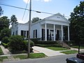 | December 2, 1974 (#74000929) | New Orleans 29°56′10″N 90°07′36″W / 29.936071°N 90.126598°W / 29.936071; -90.126598 (James H. Dillard House) | Orleans | This was the home of James Hardy Dillard, an educator at Tulane University and director of the Slater Fund and Jeanes Foundation. Born in 1856, Dillard spent most of his life improving the education of blacks in the United States.[7][8] |
| 6 | Evergreen Plantation | 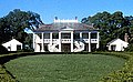 | April 27, 1992 (#91001386) | Wallace 30°01′38″N 90°38′26″W / 30.0272°N 90.64056°W / 30.0272; -90.64056 (Evergreen Plantation) | St. John the Baptist | Composed of 37 buildings, including a main house and 22 extant slave cabins, Evergreen Plantation is an intact example of major plantation complexes found during the antebellum era of the Southern United States.[9] Open to visitors. |
| 7 | Fort De La Boulaye | Upload image | October 9, 1960 (#66000378) | Phoenix 29°38′57″N 89°56′40″W / 29.649167°N 89.94444°W / 29.649167; -89.94444 (Fort De La Boulaye) | Plaquemines | Fort De La Boulaye was a fort built in 1699–1700, when France took control of the mouth of the Mississippi River. |
| 8 | Fort Jackson |  | December 19, 1960 (#66000379) | Triumph 29°21′28″N 89°27′18″W / 29.35778°N 89.455°W / 29.35778; -89.455 (Fort Jackson) | Plaquemines | Constructed on the lower Mississippi River after the War of 1812, it was the site of the Battle of Forts Jackson and St. Philip in 1862. A public park, the fort was flooded for several weeks in 2005 after two hurricanes. |
| 9 | Fort Jesup | 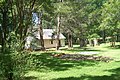 | July 4, 1961 (#66000381) | Many 31°36′41″N 93°24′03″W / 31.611389°N 93.40083°W / 31.611389; -93.40083 (Fort Jesup) | Sabine | Fort Jesup was built in 1822–32, to help protect the western border between American and Spanish territories. Under the command of future U.S. President Zachary Taylor, soldiers at the fort monitored Texas as it passed from Spanish and Mexican control, until the Mexican–American War in 1846.[10] |
| 10 | Fort St. Philip |  | December 19, 1960 (#66000380) | Triumph 29°21′50″N 89°27′46″W / 29.36389°N 89.46278°W / 29.36389; -89.46278 (Fort St. Philip) | Plaquemines | Established on the Mississippi River in the 18th century, Fort St. Philip's major engagements were 10-day naval sieges during the War of 1812 and American Civil War. The site is privately owned and has deteriorated greatly because of river flooding, erosion, and tropical storms. |
| 11 | Gallier Hall | 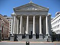 | May 30, 1974 (#74002250) | New Orleans 29°56′56″N 90°04′15″W / 29.948854°N 90.070820°W / 29.948854; -90.070820 (Gallier Hall) | Orleans | Designed by James Gallier (Sr.) in the mid-1800s; City Hall until mid-20th century and continues in use for civic and community purposes. |
| 12 | Gallier House |  | May 30, 1974 (#74000932) | New Orleans 29°57′41″N 90°03′42″W / 29.961457°N 90.061583°W / 29.961457; -90.061583 (Gallier House) | Orleans | Beautifully restored home designed by James Gallier Jr. |
| 13† | Garden District | 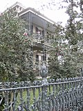 | May 30, 1974 (#71000358) | New Orleans 29°55′40″N 90°05′05″W / 29.92778°N 90.0847°W / 29.92778; -90.0847 (Garden District) | Orleans | |
| 14 | Nicholas Girod House | 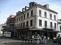 | April 15, 1970 (#70000254) | New Orleans 29°57′21″N 90°03′55″W / 29.955886°N 90.065179°W / 29.955886; -90.065179 (Nicholas Girod House) | Orleans | Originally constructed in 1797, by 1821 it was owned by former Mayor Nicolas Girod, a wealthy French American who refurbished it in preparation for a rescue of Napoleon from his exile. Word was received of Napoleon's death —the building is commonly known as the Napoleon House. Since 1914 has functioned as the Napoleon House restaurant. |
| 15 | Hermann-Grima House |  | May 30, 1974 (#710003591) | New Orleans 29°57′26″N 90°04′03″W / 29.957307°N 90.067484°W / 29.957307; -90.067484 (Hermann-Grima House) | Orleans | |
| 16 | Homeplace Plantation House |  | April 15, 1970 (#70000842) | Hahnville 29°58′16″N 90°24′27″W / 29.971057°N 90.407583°W / 29.971057; -90.407583 (Homeplace Plantation House) | St. Charles | Built circa 1790, large French Colonial raised cottage. Not open to the public. |
| 17 | Jackson Square |  | October 9, 1960 (#66000375) | New Orleans 29°57′20″N 90°03′47″W / 29.955645°N 90.063056°W / 29.955645; -90.063056 (Jackson Square) | Orleans | Central square of the Vieux Carré, historically called the Place d'Armes (Plaza de Armas). Redesigned as a public park and renamed in the mid-19th century, by Micaela Almonester, Baroness de Pontalba. |
| 18 | USS KIDD (Destroyer) | 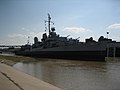 | January 14, 1986 (#83000502) | Baton Rouge 30°26′40″N 91°11′29″W / 30.44431°N 91.19151°W / 30.44431; -91.19151 (USS KIDD (Destroyer)) | East Baton Rouge | |
| 19 | Lafitte's Blacksmith Shop |  | April 15, 1970 (#70000255) | New Orleans 29°57′38″N 90°03′50″W / 29.960591°N 90.063885°W / 29.960591; -90.063885 (Lafitte's Blacksmith Shop) | Orleans | Late 18th-century Creole cottage, became a bar in the 20th century. |
| 20 | Longue Vue House and Gardens | 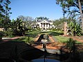 | April 5, 2005 (#91001419) | New Orleans 29°58′36″N 90°07′23″W / 29.976753°N 90.123092°W / 29.976753; -90.123092 (Longue Vue House and Gardens) | Orleans | |
| 21 | Los Adaes |  | June 23, 1986 (#78001427) | Robeline 31°42′31″N 93°17′36″W / 31.70861°N 93.2933°W / 31.70861; -93.2933 (Los Adaes) | Natchitoches | Los Adaes was the capital of Tejas, on the northeastern frontier of New Spain, from 1729 to 1770. It included a mission, San Miguel de los Adaes, and a presidio, Nuestra Senora del Pilar de Los Adaes (Our Lady of Pilar of the Adaes). |
| 22 | Louisiana State Bank Building | 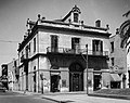 | May 4, 1983 (#83004387) | New Orleans 29°57′22″N 90°03′59″W / 29.956014°N 90.066466°W / 29.956014; -90.066466 (Louisiana State Bank Building) | Orleans | |
| 23 | Louisiana State Capitol Building and Gardens |  | December 17, 1982 (#78001421) | Baton Rouge 30°27′25″N 91°11′14″W / 30.45704°N 91.18736°W / 30.45704; -91.18736 (Louisiana State Capitol Building and Gardens) | East Baton Rouge | |
| 24 | Madame John's Legacy | 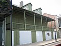 | April 15, 1970 (#70000256) | New Orleans 29°57′34″N 90°03′46″W / 29.959332°N 90.062902°W / 29.959332; -90.062902 (Madame John's Legacy) | Orleans | One of the few French Colonial-style houses in the Quarter to survive the city's great fires of the late 18th century, its name comes from a story by George Washington Cable. |
| 25 | Madewood Plantation House | 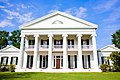 | May 4, 1983 (#73000860) | Napoleonville 29°55′37″N 90°59′40″W / 29.927°N 90.99444°W / 29.927; -90.99444 (Madewood Plantation House) | Assumption | Architect Henry Howard's first major building, begun in 1846. |
| 26 | Magnolia Plantation | 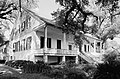 | January 3, 2001 (#79001071) | Derry 31°32′59″N 92°56′26″W / 31.5497°N 92.94056°W / 31.5497; -92.94056 (Magnolia Plantation) | Natchitoches | |
| 27 | Marksville Prehistoric Indian Site | 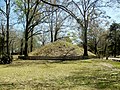 | July 19, 1964 (#66000372) | Marksville 31°07′29″N 92°02′52″W / 31.12472°N 92.04778°W / 31.12472; -92.04778 (Marksville Prehistoric Indian Site) | Avoyelles | Archeological type site for Marksville culture. |
| 28† | Melrose Plantation |  | May 30, 1974 (#72000556) | Melrose 31°05′16″N 92°58′03″W / 31.087711°N 92.967561°W / 31.087711; -92.967561 (Melrose Plantation) | Natchitoches | Black businesswoman Marie Thérèse Coincoin created this plantation, includes perhaps the first black-for-black-designed buildings in the United States. |
| 29† | Natchitoches Historic District |  | April 16, 1984 (#74000928) | Natchitoches 31°45′16″N 93°05′32″W / 31.754330°N 93.092108°W / 31.754330; -93.092108 (Natchitoches Historic District) | Natchitoches | Natchitoches is the oldest permanent settlement in the lower Mississippi River Valley, founded by the French in 1714 (four years before New Orleans). |
| 30 | New Orleans Cotton Exchange Building | 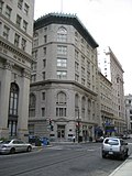 | December 22, 1977 (#77000675) | New Orleans 29°57′09″N 90°04′16″W / 29.952394°N 90.071001°W / 29.952394; -90.071001 (New Orleans Cotton Exchange Building) | Orleans | |
| 31 | Oak Alley Plantation |  | December 2, 1974 (#74002187) | Vacherie 30°00′15″N 90°46′33″W / 30.00428°N 90.775933°W / 30.00428; -90.775933 (Oak Alley Plantation) | St. James | |
| 32 | Old Louisiana State Capitol | 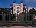 | May 30, 1974 (#73000862) | Baton Rouge 30°26′48″N 91°11′21″W / 30.44657°N 91.18903°W / 30.44657; -91.18903 (Old Louisiana State Capitol) | East Baton Rouge | Innovatively designed by architect James H. Dakin, it is "Castellated Gothic". |
| 33 | Parlange Plantation House |  | May 30, 1974 (#70000258) | Mix 30°37′49″N 91°29′10″W / 30.63028°N 91.4861°W / 30.63028; -91.4861 (Parlange Plantation House) | Pointe Coupee | |
| 34 | Pontalba Buildings |  | May 30, 1974 (#74000934) | New Orleans 29°57′27″N 90°03′44″W / 29.957580°N 90.062145°W / 29.957580; -90.062145 (Pontalba Buildings) | Orleans | |
| 35 | Port Hudson | 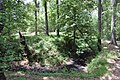 | May 30, 1974 (#74002349) | Port Hudson 30°41′36″N 91°16′33″W / 30.6933°N 91.27585°W / 30.6933; -91.27585 (Port Hudson) | East Feliciana | Port Hudson State Historic Site, an American Civil War battleground, the last Confederate stronghold on the Mississippi River. The Port Hudson National Cemetery is approximately six miles south, in East Baton Rouge Parish. |
| 36 | Poverty Point National Monument |  | April 15, 1970 (#66000382) | Delhi 32°38′12″N 91°24′41″W / 32.63667°N 91.41139°W / 32.63667; -91.41139 (Poverty Point National Monument) | West Carroll | |
| 37 | The Presbytere |  | April 15, 1970 (#70000257) | New Orleans 29°57′28″N 90°03′48″W / 29.957830°N 90.063450°W / 29.957830; -90.063450 (The Presbytere) | Orleans | Iconic building on Jackson Square, planned in the 1790s during the Spanish colonial era as the twin of the Cabildo. Second floor wasn't completed until 1813, during early statehood, with the third floor added in the 1840s. Since 1911, the Presbytere has belonged to the Louisiana State Museum. |
| 38 | Jean Pierre Emmanuel Prud'homme Oakland Plantation |  | January 3, 2001 (#79001073) | Natchez 31°39′54″N 93°00′12″W / 31.665°N 93.00333°W / 31.665; -93.00333 (Jean Pierre Emmanuel Prud'homme Oakland Plantation) | Natchitoches | |
| 39† | Rosedown Plantation |  | April 5, 2005 (#01000765) | St. Francisville 30°47′46″N 91°22′15″W / 30.796015°N 91.370945°W / 30.796015; -91.370945 (Rosedown Plantation) | West Feliciana | |
| 40 | Saint Alphonsus Church |  | June 19, 1996 (#73000872) | New Orleans 29°55′50″N 90°04′25″W / 29.930556°N 90.0736°W / 29.930556; -90.0736 (Saint Alphonsus Church) | Orleans | |
| 41 | St. Charles Streetcar Line |  | August 25, 2014 (#73000873) | New Orleans 29°55′38″N 90°05′40″W / 29.927155°N 90.094335°W / 29.927155; -90.094335 (St. Charles Streetcar Line) | Orleans | Most extensive streetcar line in the country; oldest continuously operated light-rail line in the world |
| 42 | St. Mary's Assumption Church |  | May 30, 1974 (#71000361) | New Orleans 29°55′48″N 90°04′27″W / 29.929888°N 90.074293°W / 29.929888; -90.074293 (St. Mary's Assumption Church) | Orleans | |
| 43 | St. Patrick's Church |  | May 30, 1974 (#74000936) | New Orleans 29°56′48″N 90°04′12″W / 29.946631°N 90.070137°W / 29.946631; -90.070137 (St. Patrick's Church) | Orleans | |
| 44 | San Francisco Plantation House | 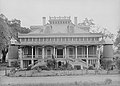 | May 30, 1974 (#74002186) | Reserve 30°02′51″N 90°36′20″W / 30.047535°N 90.605548°W / 30.047535; -90.605548 (San Francisco Plantation House) | St. John the Baptist | |
| 45 | Shadows-on-the-Teche |  | May 30, 1970 (#72000553) | New Iberia 30°00′16″N 91°48′56″W / 30.00439°N 91.81566°W / 30.00439; -91.81566 (Shadows-on-the-Teche) | Iberia | The Greek Revival home was completed in 1834 on the Bayou Teche by wealthy planters David and Mary Weeks, within the town of New Iberia. It remained in the Weeks family until 1958, when William Weeks Hall died and donated the building to the National Trust for Historic Preservation. Open for tours. |
| 46 | Shreveport Municipal Memorial Auditorium | 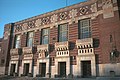 | October 6, 2008 (#91000624) | Shreveport 32°30′29″N 93°45′11″W / 32.50793°N 93.75296°W / 32.50793; -93.75296 (Shreveport Municipal Memorial Auditorium) | Caddo | |
| 47 | Shreveport Water Works Company, Pump Station |  | December 17, 1982 (#80001707) | Shreveport 32°31′04″N 93°45′26″W / 32.51769°N 93.7571°W / 32.51769; -93.7571 (Shreveport Water Works Company, Pump Station) | Caddo | An engineering landmark. |
| 48 | United States Customhouse |  | December 2, 1974 (#74000938) | New Orleans 29°57′05″N 90°03′59″W / 29.951414°N 90.066254°W / 29.951414; -90.066254 (United States Customhouse) | Orleans | |
| 49 | United States Court of Appeals—Fifth Circuit |  | July 21, 2015 (#74000937) | New Orleans 29°56′52″N 90°04′45″W / 29.94778°N 90.07917°W / 29.94778; -90.07917 (United States Court of Appeals—Fifth Circuit) | Orleans | 1909 courthouse was where many key court cases brought during the Civil Rights Movement were decided |
| 50 | United States Mint, New Orleans Branch |  | May 15, 1975 (#73000875) | New Orleans 29°57′41″N 90°03′26″W / 29.961436°N 90.057266°W / 29.961436; -90.057266 (United States Mint, New Orleans Branch) | Orleans | Minted both gold and silver coinage during the antebellum years of the 19th century; also served briefly as a C.S.A. mint. |
| 51 | Old Ursuline Convent |  | October 9, 1960 (#66000376) | New Orleans 29°57′39″N 90°03′39″W / 29.960753°N 90.060813°W / 29.960753; -90.060813 (Old Ursuline Convent) | Orleans | Convent established early in the colonial era by Ursuline nuns and New Orleans' oldest-surviving French Colonial building (1752). |
| 52† | Vieux Carre Historic District |  | December 21, 1965 (#66000377) | New Orleans 29°57′31″N 90°03′54″W / 29.9586°N 90.065°W / 29.9586; -90.065 (Vieux Carre Historic District) | Orleans | Meaning "Old Square," the original 18th-century town of New Orleans, laid out in a grid plan and known today as the French Quarter. |
| 53 | Edward Douglass White House |  | December 8, 1976 (#76000964) | Thibodaux 29°45′15″N 90°43′46″W / 29.754028°N 90.72931°W / 29.754028; -90.72931 (Edward Douglass White House) | Lafourche | Home of Edward Douglass White, his home has been rumored to be haunted. They say who ever goes inside at exactly 11:00pm on December 8, comes out with almost no memory. |
| 54 | Agudath Achim Anshe Sfard Synagogue | 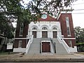 | August 2, 2017 (#100001432) | New Orleans 29°56′04″N 90°04′55″W / 29.93432°N 90.08184°W / 29.93432; -90.08184 (Agudath Achim Anshe Sfard Synagogue) | Orleans | Modern Orthodox Synagogue |
Former National Historic Landmarks
| Landmark name[11] | Image | Date designated[11] | Date withdrawn[11] | Locality[11][12] | Parish[11] | Description[13] | |
|---|---|---|---|---|---|---|---|
| 1 | U.S.S. Cabot |  | June 29, 1990 (#90000334) | August 7, 2001 | New Orleans | Commissioned during 1943, The USS Cabot (CVL-28/AVT-3) was an Independence-class aircraft carrier in the United States Navy. From 1967 to 1989, it was used by the Spanish navy as the Dédalo. A New Orleans–based museum foundation purchased the ship for restoration during 1990, but was unable to obtain sufficient funding. The Cabot was eventually scrapped and withdrawn as a Landmark on August 7, 2001.[14] | |
| 2 | Kate Chopin House |  | April 19, 1993 (#93001601) | December 28, 2015 | Cloutierville 31°32′20″N 92°55′02″W / 31.538890°N 92.917092°W / 31.538890; -92.917092 (Kate Chopin House) | Natchitoches | Home of Kate Chopin, author of The Awakening, source for her writings on bayou life.[15] It was destroyed by fire in 2008. |
| 3 | DELUGE (Firefighting Tug) | 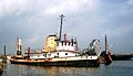 | June 30, 1989 (#89001427) | December 11, 2023 | New Orleans 29°57′15″N 90°03′18″W / 29.954109°N 90.054868°W / 29.954109; -90.054868 (DELUGE (Firefighting Tug)) | Orleans | The DELUGE, a fireboat that served the Port of New Orleans, is an example of large fireboats found in major ports during the 1920s.[16] |
National Park Service areas in Louisiana
National Historic Sites and other National Park Service areas in Louisiana are:
- Cane River Creole National Historical Park
- Chalmette National Cemetery
- El Camino Real de los Tejas National Historic Trail
- Jean Lafitte National Historical Park and Preserve
- New Orleans Jazz National Historical Park
- Poverty Point National Monument
- Vicksburg National Military Park (also in Mississippi)
Poverty Point National Monument is listed as a National Park Service area although title for the site has not been transferred from Louisiana to the federal government. Otherwise, excepting the El Camino Real de los Tejas trail, these are federally owned sites and enjoy greater protection than most National Historic Landmarks.
See also
- List of National Historic Landmarks by state
- National Register of Historic Places listings in Louisiana
- Historic preservation
- History of Louisiana
References
- ^ National Park Service. "National Historic Landmarks Program: Questions and Answers". Retrieved September 21, 2007.
- ^ Numbers represent an alphabetical ordering by significant words. Various colorings, defined here, differentiate National Historic Landmarks and historic districts from other NRHP buildings, structures, sites or objects.
- ^ The eight-digit number below each date is the number assigned to each location in the National Register Information System database, which can be viewed by clicking the number.
- ^ "Acadian House". National Historic Landmarks Program. National Park Service. Archived from the original on March 8, 2011. Retrieved February 11, 2010.
- ^ "Cable, George Washington, House". National Historic Landmarks Program. National Park Service. Archived from the original on March 8, 2011. Retrieved February 11, 2010.
- ^ "The Courthouse and Lawyers' Row". National Park Service. Retrieved May 21, 2018.
- ^ "Dillard, James H., Home". National Historic Landmarks Program. National Park Service. Archived from the original on March 8, 2011. Retrieved February 12, 2010.
- ^ "James Hardy Dillard". The Journal of Negro History. 25 (4). Association for the Study of African-American Life and History, Inc.: 585–586 October 1940. doi:10.1086/JNHv25n4p585. JSTOR 2715156. S2CID 224828031.
- ^ "Evergreen Plantation". National Register of Historic Places Travel Itinerary. National Park Service. Retrieved November 14, 2015.
- ^ "Fort Jesup". Cane River National Heritage Area: A National Register of Historic Places Travel Itinerary. National Park Service. Retrieved April 20, 2010.
- ^ a b c d e National Park Service (June 2011). "National Historic Landmarks Survey: List of National Historic Landmarks by State" (PDF). Archived from the original (PDF) on November 5, 2011. Retrieved July 4, 2011..
- ^ National Park Service. "National Historic Landmark Program: NHL Database". Archived from the original on June 6, 2004. Retrieved August 14, 2007.
- ^ National Park Service. "National Historic Landmark Program: NHL Database". Archived from the original on June 6, 2004. Retrieved on various dates.
- ^ "U.S.S. CABOT (CVL-28)". National Historic Landmarks Program. National Park Service. Retrieved February 11, 2010.
- ^ "Chopin, Kate, House". National Historic Landmarks Program. National Park Service. Archived from the original on January 14, 2009. Retrieved February 11, 2010.
- ^ "DELUGE (Firefighting Tug)". National Historic Landmarks Program. National Park Service. Archived from the original on March 19, 2005. Retrieved February 12, 2010.
External links
Wikimedia Commons has media related to National Historic Landmarks in Louisiana.
- "National Historic Landmarks Survey: List of National Historic Landmarks by State—Louisiana (53)" (PDF). National Park Service. Archived from the original (PDF) on June 11, 2007. Retrieved November 17, 2007.
- National Historic Landmarks Program, at National Park Service
- National Park Service listings of National Historic Landmarks
- v
- t
- e
- Alabama
- Alaska
- Arizona
- Arkansas
- California
- Colorado
- Connecticut
- Delaware
- Florida
- Georgia
- Hawaii
- Idaho
- Illinois
- Indiana
- Iowa
- Kansas
- Kentucky
- Louisiana
- Maine
- Maryland
- Massachusetts
- Michigan
- Minnesota
- Mississippi
- Missouri
- Montana
- Nebraska
- Nevada
- New Hampshire
- New Jersey
- New Mexico
- New York
- North Carolina
- North Dakota
- Ohio
- Oklahoma
- Oregon
- Pennsylvania
- Rhode Island
- South Carolina
- South Dakota
- Tennessee
- Texas
- Utah
- Vermont
- Virginia
- Washington
- West Virginia
- Wisconsin
- Wyoming
| Insular area | |
|---|---|
| Associated state | |
| Foreign country |

| |
|---|---|
| Topics | |
| Lists by state |
|
| Lists by insular areas | |
| Lists by associated state | |
| Other areas | |
| Related | |
| |


