42°15′20″N 8°56′25″E / 42.25556°N 8.94028°E / 42.25556; 8.94028| Type | glacial |
|---|
| Primary outflows | Tavignano |
|---|
| Basin countries | France |
|---|
|
|---|
| Surface area | 0.065 km2 (0.025 sq mi) |
|---|
| Max. depth | 12 m (39 ft) |
|---|
| Surface elevation | 1,743 m (5,719 ft) |
|---|
Lac de Nino is a lake in Haute-Corse, France. At an elevation of 1743 m, its surface area is 0.065 km².
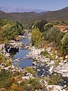
The lake is on the Tavignano river near to its source below the 1,883 metres (6,178 ft) Bocca a Reta. It is on the boundary between the communes of Casamaccioli and Corte. The river flows through marshy land above and below the lake.
References
Sources
- "Way: Lac de Nino (28890021)", OpenStreetMap, retrieved 2021-12-18
| Waterbodies | |
|---|
| Rivers and streams | Clockwise; west to north to east to south | | Coastal | | West coast | |
|---|
| Cap Corse | |
|---|
| East coast | |
|---|
| |
|---|
| Tributaries | |
|---|
|
|---|
- Communes
- Landforms
- Waterbodies
|
 | This Haute-Corse geographical article is a stub. You can help Wikipedia by expanding it. |