Kyoto Municipal Subway
Rapid transit system in Kyoto, Japan
You can help expand this article with text translated from the corresponding article in Japanese. (December 2022) Click [show] for important translation instructions.
- Machine translation, like DeepL or Google Translate, is a useful starting point for translations, but translators must revise errors as necessary and confirm that the translation is accurate, rather than simply copy-pasting machine-translated text into the English Wikipedia.
- Do not translate text that appears unreliable or low-quality. If possible, verify the text with references provided in the foreign-language article.
- You must provide copyright attribution in the edit summary accompanying your translation by providing an interlanguage link to the source of your translation. A model attribution edit summary is
Content in this edit is translated from the existing Japanese Wikipedia article at [[:ja:京都市営地下鉄]]; see its history for attribution. - You may also add the template
{{Translated|ja|京都市営地下鉄}}to the talk page. - For more guidance, see Wikipedia:Translation.
| System map |
|---|
|
|
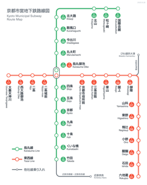
The Kyoto Municipal Subway (京都市営地下鉄, Kyōto-shiei chikatetsu), also known as Kyoto City Subway, is the rapid transit network in the city of Kyoto, Japan. Operated by the Kyoto Municipal Transportation Bureau, it has two lines.
Lines
The Kyoto Municipal Subway is made up of two lines: the 13.7-kilometer (8.5 mi) long, 15-station Karasuma Line, and the 17.5-kilometer (10.9 mi) long, 17-station Tōzai Line, which together share one interchange station (Karasuma Oike Station):[2]
| Color & Icon | Mark | Name | First section opened | Last ex- tension | Length | Stations | ||
|---|---|---|---|---|---|---|---|---|
| green |  | K | - | Karasuma Line | 1981 | 1997 | 13.7 km (8.5 mi) | 15 |
| - | Via trackage rights | Kintetsu Kyōto Line | 1988[a] | 2000 | 31.0 km (19.3 mi) | 22[b] | ||
| Kintetsu Nara Line | 2000[c] | - | 4.4 km (2.7 mi) | 3[d] | ||||
| vermilion |  | T | - | Tōzai Line | 1997[e] | 2004 | 8.7 km (5.4 mi) | 8 |
| Via trackage rights | 1997[f] | - | 3.4 km (2.1 mi) | 3[g] | ||||
| - | 1997[h] | - | 3.0 km (1.9 mi) | 4[i] | ||||
| - | 2008[j] | - | 2.4 km (1.5 mi) | 2[k] | ||||
| Total | 31.2 km (19.4 mi) | 31 | ||||||
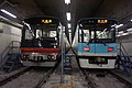
Rolling stock
Karasuma Line
- Kyoto Municipal Subway 10 series
- Kyoto Municipal Subway 20 series
- Kintetsu 3200 series
- Kintetsu 3220 series
-
 Kyoto Municipal Subway 10 series
 -
 Kyoto Municipal Subway 20 series
 -
 Kintetsu 3200 series
 -
 Kintetsu 3220 series


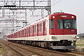
Tozai Line
- Kyoto Municipal Subway 50 series
- Keihan 800 series
-
 Kyoto Municipal Subway 50 series and Keihan 800 series

Network Map

See also
- Transport in Keihanshin
- List of metro systems
Notes
- ^ Between Takeda Station and Yamato-Saidaiji Station.
- ^ Including Takeda Station.
- ^ Between Yamato-Saidaiji Station and Kintetsu Nara Station.
- ^ Including Yamato-Saidaiji Station.
- ^ Between Rokujizō Station and Misasagi Station.
- ^ Between Misasagi Station and Sanjō Keihan Station; owned by Kyoto High-Speed Rail.
- ^ Including Keage Station, Higashiyama Station and Sanjō Keihan Station, but not including Misasagi Station.
- ^ Between Sanjō Keihan Station and Nijō Station.
- ^ Including Kyoto Shiyakusho-mae Station, Nijōjō-mae Station and Nijō Station, and the Karasuma Oike interchange station (previously counted with the Karasuma Line), but not including Sanjō Keihan Station.
- ^ Between Nijō Station and Uzumasa Tenjingawa Station.
- ^ Including Nishiōji Oike Station and Uzumasa Tenjingawa Station.
References
External links
![]() Media related to Kyoto Subway at Wikimedia Commons
Media related to Kyoto Subway at Wikimedia Commons
- Kyoto City Bus & Subway Information Guide (Official website)
- Network map (to scale)
- Kyoto Municipal Subway map
- v
- t
- e
Source: www.jametro.or.jp/en/japan/ "Subways in Japan" (Japan Subway Association)
- Rinkai Line (Tokyo)
- Minatomirai 21 Line (Yokohama)
- Saitama Rapid Railway Line
- Tōyō Rapid Railway Line (Chiba)
- Hokusō Line (Tokyo/Chiba)
- Astram Line (Hiroshima)
- Japan transit: Tokyo
- Keihanshin
- Nagoya
- Fukuoka
- Hakone Fuji Izu
- Hokkaido
- Aomori
- Sendai
- Akita
- Niigata
- Toyama
- Nagano
- Okayama
- Hiroshima
- Shikoku
- Metro systems
- Shinkansen
- trams (list)
- aerial lifts (list)


Rapid transit in Asia | |
|---|---|
 Bangladesh Bangladesh | |
 China (PRC) China (PRC) |
|
 Georgia Georgia | |
 India India | |
 Indonesia Indonesia | |
 Iran Iran | |
 Japan Japan | |
 Kazakhstan Kazakhstan | |
 North Korea North Korea | |
 Malaysia Malaysia | |
 Pakistan Pakistan | |
 Philippines Philippines | |
 Qatar Qatar | |
 Russia Russia | |
 Saudi Arabia Saudi Arabia | |
 Singapore Singapore |
|
 South Korea South Korea | |
 Taiwan (ROC) Taiwan (ROC) | |
 Thailand Thailand |
|
 Turkey Turkey | |
 United Arab Emirates United Arab Emirates | |
 Uzbekistan Uzbekistan | |
 Vietnam Vietnam | |
* Under construction. | |


| Authority control databases: National |
|
|---|


