Kingsley Covered Bridge
United States historic place
Kingsley Covered Bridge | |
U.S. Historic district Contributing property | |
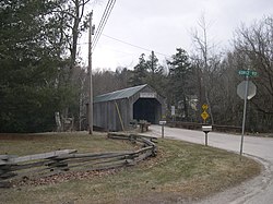 The north approach to the Kingsley bridge. The Rutland Airport landing strip is on the hill just to the right of this photo | |
| Location | Clarendon, Vermont |
|---|---|
| Coordinates | 43°31′24.74″N 72°56′29.85″W / 43.5235389°N 72.9416250°W / 43.5235389; -72.9416250 |
| Area | 1 acre (0.40 ha) |
| Built | 1870 (1870) |
| Architect | Timothy K. Horton |
| Part of | Kingsley Grist Mill Historic District (ID07001170) |
| NRHP reference No. | 74000257 [1] |
| Significant dates | |
| Added to NRHP | February 12, 1974 |
| Designated CP | November 8, 2007 |
The Kingsley Covered Bridge (also called the Mill River Bridge) is a wooden covered bridge carrying East Street across the Mill River in Clarendon, Vermont. Built about 1870, it is the town's only surviving 19th-century covered bridge. The bridge was listed on the National Register of Historic Places in 1974.[1]
Description and history
The Kingsley Covered Bridge is located west of Vermont Route 103 and just under the landing strip for the Rutland Airport on East Street Extension off Gorge Road, a paved road that turns to dirt after crossing the bridge. It is adjacent to the Kingsley Grist Mill Historic District, consisting of a restored mill and houses. The bridge has a 3-ton weight limit.
The bridge is a single-span Town lattice truss structure, 121 feet (37 m) long and 17.5 feet (5.3 m) wide, with a roadway width of 14 feet (4.3 m) (one lane). The trusses rest on abutments that have been faced in concrete. The exterior is finished in vertical board siding, which extends from the sides, around the portals, and just inside the portals. It has a roof of corrugated metal.[2]
The bridge bears a sign claiming to have been built in 1836, but the National Register nomination claims a construction date of about 1870. The bridge was built by Timothy K. Horton (1814-1896),[3] and is the town's last surviving 19th-century bridge.[2] The site has apparently had a bridge since the late 18th century, with references to a crossing being authorized there in 1788.[3]
See also
- National Register of Historic Places listings in Rutland County, Vermont
- List of Vermont covered bridges
- List of bridges on the National Register of Historic Places in Vermont
References
- ^ a b "National Register Information System". National Register of Historic Places. National Park Service. January 23, 2007.
- ^ a b "NRHP nomination for Kingsley Covered Bridge". National Park Service. Retrieved April 10, 2016.
- ^ a b "NRHP nomination for Kingsley Grist Mill Historic District". National Park Service. Retrieved April 11, 2016.
Wikimedia Commons has media related to Kingsley Covered Bridge.
- v
- t
- e
Historic
Landmark

- Benson Village
- Brandon State School
- Brandon Village Historic District
- Castleton Village Historic District
- Danby Village Historic District
- East Poultney Historic District
- Fair Haven Green Historic District
- Gifford Woods State Park
- Hosford–Sherman Farm
- Kingsley Grist Mill Historic District
- Marble Street Historic District
- Middletown Springs Historic District
- Mission of the Church of Our Savior
- Mountain View Stock Farm
- Pittsford Green Historic District
- Poultney Main Street Historic District
- Rural Otter Creek Valley Historic District
- Rutland Courthouse Historic District
- Rutland Downtown Historic District
- Simeon Smith Mansion
- Tinmouth Historic District
- Wallingford Main Street Historic District
| Commercial |
|
|---|---|
| Education |
|
| Government | |
| Industrial | |
| Religious | |
| Residential |
|
| Transportation |
- Bridge 4
- Colburn Bridge
- Cold River Bridge
- Cooley Covered Bridge
- Dean Covered Bridge
- Depot Covered Bridge
- Gorham Covered Bridge
- Hammond Covered Bridge
- Kingsley Covered Bridge
- Marble Bridge
- Sanderson Covered Bridge


