Kiên Hải district
You can help expand this article with text translated from the corresponding article in Vietnamese. (March 2009) Click [show] for important translation instructions.
- View a machine-translated version of the Vietnamese article.
- Machine translation, like DeepL or Google Translate, is a useful starting point for translations, but translators must revise errors as necessary and confirm that the translation is accurate, rather than simply copy-pasting machine-translated text into the English Wikipedia.
- Do not translate text that appears unreliable or low-quality. If possible, verify the text with references provided in the foreign-language article.
- You must provide copyright attribution in the edit summary accompanying your translation by providing an interlanguage link to the source of your translation. A model attribution edit summary is
Content in this edit is translated from the existing Vietnamese Wikipedia article at [[:vi:Kiên Hải]]; see its history for attribution. - You may also add the template
{{Translated|vi|Kiên Hải}}to the talk page. - For more guidance, see Wikipedia:Translation.
District in Mekong Delta, Vietnam
Kiên Hải district Huyện đảo Kiên Hải | |
|---|---|
District (Island) | |
| Kiên Hải Island district | |
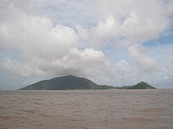 Hon Tre islet | |
| Country |  Vietnam Vietnam |
| Region | Mekong Delta |
| Province | Kiên Giang |
| Capital | Hon Tre |
| Area | |
| • Total | 11 sq mi (28 km2) |
| Population | |
| • Total | 20,807[1] |
| Time zone | UTC+7 (Indochina Time) |
| Website | kienhai |
Kiên Hải is a rural district (huyện) of Kiên Giang province in the Mekong Delta region of Vietnam. The district consists of 23 islands, of which 11 are inhabited,[2] the main economy is fishing, aquaculture and tourism.[2]
According to 2009 census, the district has a population of 20,807.[1] The district covers an area of 28 km². The district capital lies at Hon Tre island.[3] The district contains parts of the archipelago of the Bà Lụa Islands and Nam Du Islands.
The district includes four communes - Hòn Tre, Lại Sơn, An Sơn and Nam Du.[2]
References
- ^ a b "Part I - Tabulated Tables, Table 2 - population by urban/rural residence, sex and district". The 2009 Vietnam Population and Housing census: Completed results (Report). Central Population and Housing Census Steering Committee, General Statistic Office of Viet Nam. June 2010. p. 33. Retrieved May 13, 2020.
- ^ a b c "Kiên Giang: Huyện đảo Kiên Hải phát triển du lịch thành ngành kinh tế chủ lực" [Kiên Giang: Kiên Hải island district to develop tourism into a major economic sector] (in Vietnamese).
- ^ "People's Committee Kiên Hải"., address at the bottom
10°00′00″N 104°45′00″E / 10.000°N 104.750°E / 10.000; 104.750
- v
- t
- e
Districts of the Mekong Delta

- Cao Lãnh city※
- Hồng Ngự city
- Sa Đéc city
- Cao Lãnh
- Châu Thành
- Hồng Ngự
- Lai Vung
- Lấp Vò
- Tân Hồng
- Tam Nông
- Thanh Bình
- Tháp Mười
- Ngã Bảy city
- Vị Thanh city※
- Long Mỹ town
- Châu Thành
- Châu Thành A
- Long Mỹ
- Phụng Hiệp
- Vị Thủy
- Hà Tiên city
- Rạch Giá city※
- Phú Quốc Island city
- An Biên
- An Minh
- Châu Thành
- Giang Thành
- Giồng Riềng
- Gò Quao
- Hòn Đất
- Kiên Hải Island
- Kiên Lương
- Tân Hiệp
- U Minh Thượng
- Vĩnh Thuận
- Mỹ Tho city※
- Cai Lậy town
- Gò Công town
- Cái Bè
- Cai Lậy
- Châu Thành
- Chợ Gạo
- Gò Công Đông
- Gò Công Tây
- Tân Phú Đông
- Tân Phước
※ denotes provincial seat.
 | This article about a location in Kiên Giang province, Vietnam is a stub. You can help Wikipedia by expanding it. |
- v
- t
- e


 Kiên_Hải_district