Kanab Creek Trail
Hiking trail in the Grand Canyon National Park
36°23′32″N 112°37′47″W / 36.3923°N 112.6296°W / 36.3923; -112.6296 Grand Canyon National Park, Arizona, United StatesOverexertion
Dehydration
Flash Flood
The Kanab Creek Trail is a hiking trail on the North Rim of the Grand Canyon National Park, located in the U.S. state of Arizona. It is named after the adjacent Kanab Creek.
See also
- The Grand Canyon
- List of trails in Grand Canyon National Park
Photo gallery
-
 Jumpup Canyon
 -
 Kanab Creek
 -
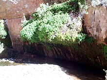 Showerbath Spring


External links
- Kaibab National Forest Ranger Trail #59, in Kanab Creek from Snake Gulch to Jensen Canyon and beyond.
- Travelogue of backpacking trip in Kanab Creek
- Hiking guide to Kanab Creek
- U.S. Geological Survey 1:250,000 map, Grand Canyon, Arizona, NJ 12-10 Series V502, Edition 3, 1953 revised 1970. (8 MB download)
- v
- t
- e
- Beamer Trail
- Bill Hall Trail
- Boucher Trail
- Bright Angel Trail
- Clear Creek Trail
- Deer Creek Trail
- Dripping Springs Trail
- Escalante Route
- Esplanade Route
- Grandview Trail
- Havasupai Trail
- Hermit Trail
- Kanab Creek Trail
- Lava Falls Trail
- Nankoweap Trail
- New Hance Trail
- North Bass Trail
- North Kaibab Trail
- Plateau Point Trail
- River Trail
- Royal Arch Route
- South Bass Trail
- South Canyon Trail
- South Kaibab Trail
- Tanner Trail
- Thunder River Trail
- Tonto Trail
- Tuckup Trail
- Waldron Trail
 | This Coconino County, Arizona location article is a stub. You can help Wikipedia by expanding it. |
- v
- t
- e
 | This United States trail or long-distance path–related article is a stub. You can help Wikipedia by expanding it. |
- v
- t
- e


