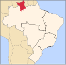
Iracema, Roraima
Municipality in North, Brazil

Flag

Coat of arms
2°10′55″N 61°2′27″W / 2.18194°N 61.04083°W / 2.18194; -61.04083
(2020 [1])
Iracema (Portuguese pronunciation: [iɾaˈsẽmɐ]) is a municipality located in the midwest of the state of Roraima in Brazil. Its population is 12,296 (2020) and its area is 14,413 km².[2] Iracema started as an agricultural community. It became an independent municipality in 1994.[3] The town is located on the BR-174 highway, and is known for its waterfall.[4]
References
Wikimedia Commons has media related to Iracema (Roraima).
- v
- t
- e

Capital: Boa Vista
 | This Roraima, Brazil location article is a stub. You can help Wikipedia by expanding it. |
- v
- t
- e


