Hatsum
Hamlet in Friesland, Netherlands
Hatsum Hatzum | |
|---|---|
Hamlet | |
 Restaurant Op Hatsum in Hatsum | |
53°10′41″N 5°38′02″E / 53.17812°N 5.63400°E / 53.17812; 5.63400 | |
| Country | Netherlands |
| Province | Friesland |
| Municipality | Waadhoeke |
| Village | Dronryp |
| Elevation [1] | 1.0 m (3.3 ft) |
| Population [2] | |
| • Total | c. 45 |
| Time zone | UTC+1 (CET) |
| • Summer (DST) | UTC+2 (CEST) |
| Postcode | 9035 |
| Area code | 0517 |
Hatsum or Hatzum (Dutch pronunciation: [ˈɦɑt.sʏm]) is a hamlet in the Dutch municipality of Waadhoeke in the province of Friesland. It is located north of Baaium and south of Dronryp, of which it is a part administratively.
The mainly dispersed residences of the hamlet are located on the roads Longbuorren, Hatzum, Keimptilsterdyk and a part of Rewertdyk (up to the Molensloot). The residences on the Dykshoek on the Van Harinxma Canal [nl] are also included in the hamlet, even though it actually belongs to the Kingmatille hamlet. The Hatsumer Opfeart also flows through the hamlet.
Built on a terp,[3] the hamlet was first mentioned in 1511 as Hastzen, in 1531 as Hatsem and in 1543 as Hatzum. On the southeastern side of Baaium was also a place of the same name, which was mentioned in 1511 as Hastzen as well. It was a large farm that was referred to as Lamkema in the 17th century, later found as a field name as Hatsem. Given the proximity, it may be directly connected. It is assumed that the place name refers to the fact that it is a place of residence (-heem/-um) of or founded by the person Hette.[4]
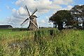
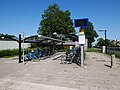
A double train track also runs through the hamlet and it therefore has a train station, Dronryp railway station. There is also a restaurant, currently called Op Hatsum. On the Hatsumeropvaart near Kingmatille is a windmill of the same name, Kingmatille which has been on that spot since 1987, and near the railway is the Hatsumermolen.
Gallery
-

-
-
-
 View from Hatsum on Baaium


References
- ^ "Postcodetool for 9035VK". Actueel Hoogtebestand Nederland (in Dutch). Het Waterschapshuis. Retrieved 9 October 2023.
- ^ "Hatsum". Plaatsengids (in Dutch). Retrieved 9 October 2023.
- ^ Algra, H.; Algra, A. (1978). Dispereert niet. Twintig eeuwen historie van de Nederlanden. Deel 1 (in Dutch). Franeker: T. Wever. p. 27. Retrieved 9 October 2023.
- ^ Van Berkel, Gerard; Samplonius, Kees (2018). Nederlandse plaatsnamen verklaard (in Dutch). Mijnbestseller.nl. ISBN 9789463679176.
External links
![]() Media related to Hatsum at Wikimedia Commons
Media related to Hatsum at Wikimedia Commons
- v
- t
- e
Populated places in the municipality of Waadhoeke
- Former municipalities: Franekeradeel
- het Bildt
- Menameradiel
- Achlum
- Alde Leie (small part)
- Baaium
- Berltsum
- Bitgum
- Bitgummole
- Blessum
- Boer
- Boksum
- Deinum
- Dongjum
- Dronryp
- Firdgum
- Herbaijum
- Hitzum
- Ingelum
- Klooster-Lidlum
- Marsum
- Menaam
- Minnertsga
- Nij Altoenae
- Oosterbierum
- Oudebildtzijl
- Peins
- Pietersbierum
- Ried
- Schalsum
- Sexbierum
- Sint Annaparochie
- Sint Jacobiparochie
- Skingen
- Slappeterp
- Spannum
- Tzum
- Tzummarum
- Vrouwenparochie
- Westhoek
- Wier
- Winsum
- Wjelsryp
- Zweins


