Grand Hogback
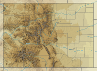

The Grand Hogback is a 70-mile long,[2] curving, spine-like ridge in Western Colorado that extends from near McClure Pass in Pitkin County through Garfield County and then to near Meeker in Rio Blanco County.[3] The hogback is significant because it marks part of the boundary between the Colorado Plateau to the west and the Southern Rocky Mountains to the east.[4]
The elevation of the ridge ranges from 7,710 ft (2,350 m) to 9,194 ft (2,802 m). The hogback appears as a series of serrated ridges and is easily discernable from Google Maps and other aerial views.[4] It is visible from Interstate 70.
Gaps
Rivers have carved out several gaps in the hogback, the most notable being the one the Colorado River has carved out near New Castle, Colorado. Others include Harvey Gap and Rifle Gap,[5] both of which have been dammed to create reservoirs and state parks.
Geology

A monocline, the Grand Hogback is part of the Mesaverde Formation. The ridge formed towards the end of the Laramide orogeny during the middle to late Eocene.[3]
References
- ^ "Grand Hogback". Geographic Names Information System. United States Geological Survey, United States Department of the Interior. Retrieved March 27, 2017.
- ^ New Castle, Colorado. Living in New Castle[permanent dead link]. Retrieved: March 27, 2017.
- ^ a b Stracher, Glenn B.; et al. (2008). "Revisiting the South Cañon Number 1 Coal Mine fire during a geologic excursion from Denver to Glenwood Springs, Colorado". In Raynolds, Robert G. H. (ed.). Roaming the Rocky Mountains and Environs: Geological Field Trips. Geological Society of America. pp. 101–110. ISBN 9780813700106.
- ^ a b Colorado Mountain College. The Grand Hogback: Living life on the edge. Retrieved: March 27, 2017.
- ^ Colorado Parks & Wildlife. Rifle Gap Archived August 17, 2015, at the Wayback Machine. Retrieved: March 27, 2017.
External links
- The Geology of the Grand Hogback Monocline near Meeker, Colorado – Colorado Geological Survey. Archived 2 March 2018 at the Wayback Machine
- v
- t
- e

- Mount Garfield
- Aspen Mountain
- Capitol Peak
- Castle Peak
- Cathedral Peak
- Chair Mountain
- Crested Butte
- Gothic Mountain
- Italian Mountain
- Maroon Bells
- Mount Emmons
- Mount Owen
- Mount Sopris
- Pyramid Peak
- Snowmass Mountain
- Snowmass Peak
- Treasure Mountain
- Black Mountain (Moffat County)
- Columbus Mountain
- Elk Mountain (Routt County)
- Hahns Peak
- Flat Top Mountain
- Sleepy Cat Peak
- Eagles Nest
- Jacque Peak
- Meridian Peak
- Mount Powell
- The Spider
- Crater Peak
- North Mamm Peak
- Clark Peak
- Arkansas Hills
- Clinton Peak
- Dyer Mountain
- Gemini Peak
- Horseshoe Mountain
- Mount Arkansas
- Mount Bross
- Mount Buckskin
- Mount Democrat
- Mount Lincoln
- Mount Sheridan
- Mount Sherman
- Pacific Peak
- West Buffalo Peak
- Elk Mountain (Grand County)
- Parkview Mountain
- Radial Mountain
- Whiteley Peak
| Sangre de Cristo Range |
|
|---|---|
| Wet Mountains |
|
| Others |
|
| Collegiate Peaks |
|
|---|---|
| Others |
|
- Crystal Peak
- Fletcher Mountain
- Peak 10
- Peak One
- Quandary Peak
- Tenmile Peak
- Bear Mountain
- Blair Mountain
- Chalk Mountains
- Cochetopa Hills
- Dawson Butte
- Diamond Peak
- Flirtation Peak
- Granite Peak
- Grand Hogback
- Grannys Nipple
- Horsefly Peak
- Lead Mountain (Grand County)
- Mount Neva
- Powell Peak
- San Luis Hills
- Storm King Mountain
- Terrible Mountain
- Two Buttes
- Ute Mountain
| Authority control databases |
|
|---|


