Gatačko Polje
43°07′56″N 18°33′19″E / 43.1322°N 18.5553°E / 43.1322; 18.5553Location Bosnia and Herzegovina Range Dinaric Alps Offshore water bodies Zalomka Age Late Mesozoic-Cenozoic (Paleogene) Formed by Thrust faulting Orogeny Alpine orogeny Geology Karst Area • Total 57–60 square kilometres (5,700–6,000 ha; 14,000–15,000 acres) Dimensions • Length 24 kilometres (15 mi) • Width 3.6–4 kilometres (2.2–2.5 mi) 
Gatačko polje (lit. 'Field of Gacko', Serbian Cyrillic: Гатачко поље) is a polje (karst field) within the Gacko municipality in Bosnia and Herzegovina, spanning 57–60 km2, being ca. 24 km long and ca. 3,6 km wide, in the northwest–southeast direction. It is situated between the mountains of Bjelašnica and Lebršnik on the altitude of 930 to 1000 m. The subterranean rivers of Gračanica and Mušnica cross the field. The only larger settlement is Gacko. Near the field are the mountains and straddle of Čemerno (with sea watershed), the source of the Trebišnjica, Klinje Lake and the Sutjeska National Park. The field develops agriculture and animal husbandry.
Gallery
-
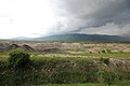
 Gacko polje before the coal mine
 -
 Gacko polje after the coal mine


See also
Wikimedia Commons has media related to Gatačko polje.
References
External links
- "The Karstography of the Dinaric karst in Bosnia and Herzegovina. Part 5.3, Eastern Herzegovina". The Devon Karst Research Society. 10 July 2007. Archived from the original on 14 May 2011. Retrieved 4 December 2014.
- Safet HadžiMuhamedović (2018) Waiting for Elijah: Time and Encounter in a Bosnian Landscape. New York and Oxford: Berghahn Books.
- v
- t
- e
Dinaric Alps' karst fields
- Bilećko Polje
- Bravsko Polje
- Čepićko Polje
- Dabarsko Polje
- Duvanjsko Polje
- Drvarsko Polje
- Gatačko Polje
- Glamočko Polje
- Grahovsko Polje
- Fatničko Polje
- Kupreško Polje
- Livanjsko Polje
- Medeno Polje
- Mostarsko Polje
- Nevesinjsko Polje
- Petrovačko Polje
- Popovo Polje
- Rakitno Polje
- Šuičko Polje

- Gacko Polje
- Gračačko Polje
- Grobničko Polje
- Imotsko Polje
- Kosovo Polje (Croatia)
- Ličko Polje
- Ličko Polje (Gorski Kotar)
- Petrovo Polje
- Sinjsko Polje
- Cetinjsko Polje
- Grahovsko Polje
- Nikšičko Polje
- Odorovsko Polje
 Category:Karst fields
| ||||||||
|---|---|---|---|---|---|---|---|---|
| Geographical |
|  | ||||||
| Historical |
| |||||||
 | This Bosnia and Herzegovina geography article is a stub. You can help Wikipedia by expanding it. |
- v
- t
- e


