Fox Stand
Historic house in Vermont, United States
United States historic place
Fox Stand | |
 | |
43°49′24″N 72°33′52″W / 43.82333°N 72.56444°W / 43.82333; -72.56444 | |
| Area | 3 acres (1.2 ha) |
|---|---|
| Built | 1818 (1818) |
| Architectural style | Federal |
| NRHP reference No. | 15000477[1] |
| Added to NRHP | July 23, 2015 |
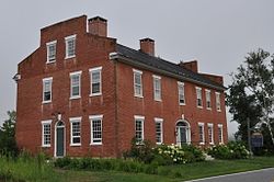
The Fox Stand is a historic multipurpose commercial and residential building at 5615 Vermont Route 14 in Royalton, Vermont. Built in 1814, it served as a tavern and traveler accommodation on the turnpike (now VT 14) that ran along the north bank of the White River. It has been adaptively reused in a variety of configurations, most recently as a restaurant and dwelling for the restaurant's operator. It was listed on the National Register of Historic Places in 2015 as a particularly fine example of a Federal period tavern.[1]
Description and history
The Fox Stand stands on the west side of Vermont Route 14, at the southern end of the village of North Royalton, and just north of the bridge carrying Royalton Hill Road across the White River. It is a 2+1⁄2-story masonry structure, built of brick and set on a stone foundation. It has a gabled roof, with stepped gable ends and two interior chimneys. The main (east-facing) facade is six bays wide, with the main entrance roughly in the center, set in a keystoned segmented-arch opening with a transom window and sidelights. Sash windows are set in rectangular openings, with splayed stone lintels. The interior retains numerous period features, including fireplaces of brick and locally quarried soapstone, and two baking ovens.[2]
The tavern was built in 1816-18 for Jacob Fox by Amasa Dutton, Jr., a prominent local builder. It was built to serve traffic on the White River Turnpike, opened in 1800, and as a social center for the community. Originally designed with a ballroom on the third floor, that space was used for local social events. In 1825 the tavern hosted the Marquis de Lafayette as he journeyed north to Montpelier. After the railroad was built through the area about 1850, the turnpike declined in use, and the tavern was closed. It was thereafter used for many years as a private residence, and was adapted for mixed commercial and residential use in the 1970s. It currently (as of 2015) houses a restaurant on the ground floor and an apartment on the second floor. The old ballroom on the third floor is intact but unused due to modern fire safety codes.[2]
See also
Wikimedia Commons has media related to Fox Stand Inn.
References
- ^ a b "National Register Information System". National Register of Historic Places. National Park Service. July 9, 2010.
- ^ a b "NRHP nomination for Fox Stand" (PDF). State of Vermont. Archived from the original (PDF) on 2016-08-18. Retrieved 2016-07-01.
External links
- The Fox Stand Tavern and Catering web site
- v
- t
- e
National Register of Historic Places in Windsor County, Vermont
Historic
Landmarks
- Calvin Coolidge Homestead District
- George Perkins Marsh Boyhood Home
- Robbins and Lawrence Armory and Machine Shop
- Stellafane Observatory

- Advent Camp Meeting Grounds Historic District
- Ascutney Mill Dam Historic District
- Ascutney State Park
- Bethel Village Historic District
- Theron Boyd Homestead
- Brigham Hill Historic District
- Brook Farm
- Chester Village Historic District
- Christian Street Rural Historic District
- Coolidge State Park
- Fletcher–Fullerton Farm
- Goodrich Four Corners Historic District
- Hartford Village Historic District
- Jericho Rural Historic District
- King Farm
- Ludlow Village Historic District
- Marsh-Billings-Rockefeller National Historical Park
- Gen. Lewis R. Morris House
- Norwich Mid-Century Modern Historic District
- Norwich Village Historic District
- Parker Hill Rural Historic District ‡
- Plymouth Historic District
- Quechee Historic Mill District
- Isaac M. Raymond Farm
- Saddlebow Farm
- Slayton–Morgan Historic District
- South Royalton Historic District
- South Woodstock Village Historic District
- Southview Housing Historic District
- Springfield Downtown Historic District
- Stockbridge Common Historic District
- Stone Village Historic District
- Taftsville Historic District
- Terraces Historic District
- Weathersfield Center Historic District
- West Hartford Village Historic District
- Weston Village Historic District
- White River Junction Historic District
- Wilder Village Historic District
- Wilgus State Park
- Windsor Village Historic District
- Woodstock Village Historic District
- Best's Covered Bridge
- Bowers Covered Bridge
- Bridge 15
- Bridgewater Corners Bridge
- Cornish–Windsor Covered Bridge‡
- Gilead Brook Bridge
- Gould's Mill Bridge
- Iron Bridge at Howard Hill Road
- Kendron Brook Bridge
- Lincoln Covered Bridge
- Martin's Mill Covered Bridge
- Ottauquechee River Bridge
- Quechee Gorge Bridge
- Spaulding Bridge
- Stockbridge Four Corners Bridge
- Taftsville Covered Bridge
- Upper Falls Covered Bridge
- West Hartford Bridge
- West Woodstock Bridge
- Willard Covered Bridge
- Woodstock Warren Through Truss Bridge
‡This historic property also has portions in an adjacent state.


