Earlscourt
Neighbourhood in Toronto, Ontario, Canada
Earlscourt | |
|---|---|
Neighbourhood | |
 Aerial view of Earlscourt from Old Weston Road in 2024 | |
 | |
| Country |  Canada Canada |
| Province |  Ontario Ontario |
| City | Toronto |
| Established | 1792 York County |
| Township | 1793 York Township |
| Annexed | 1910 Toronto |
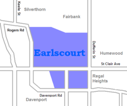
Earlscourt is a neighbourhood in Toronto, Ontario, Canada. It is centred on St. Clair Avenue West, with Dufferin Street, Davenport Road, and Old Weston Road forming its boundaries. It is contained within the larger city-recognized neighbourhood of Corso Italia-Davenport.
Earlscourt Park is located on the south side of St. Clair between Caledonia Park Road and Lansdowne Avenue.
History
Earlscourt began as a squatter settlement in the early 20th century and annexed by the City of Toronto in 1910. It was initially settled by British and Scottish immigrants. During World War I, the area had some of the highest enlistment rates in the British Empire. Several of the original settler shacks are still visible in the area. After the war the area became the centre of Toronto's Italian community, and it has remained a centre for Italian culture in Toronto. The stretch of St. Clair West that runs through the neighbourhood is known as Corso Italia.
Education
Two public school boards operate elementary schools in Earlscourt, the Toronto Catholic District School Board (TCDSB), and the Toronto District School Board (TDSB). TDSB is secular public school board, the latter schools being operated by the Toronto Board of Education. TCDSB is an English-based separate public school board. Elementary schools in the area include:
- General Mercer Junior Public School (TDSB)
- Earlscourt Junior Public School (TDSB) and Stella Maris Catholic School (TCDSB)
- Richard W. Scott Catholic School (TCDSB) - closed in 2001, demolished
TCDSB operates one anglophone secondary school in the neighborhood, Loretto College School, founded in 1915 by the Sisters of Loreto on Brunswick Avenue. The current building was built in 2005 on the former Richard W. Scott property, whose building was partly used by students of Bishop Francis Marrocco Catholic High School since its inception in 1986.
One private school serves this neighbourhood, Hudson College, which was opened in 2002 in the Earlscourt school building.
References
- Byers, Nancy; Myrvold, Barbara (2008). St. Clair West in Pictures. Toronto Public Library. ISBN 978-0-920601-62-4.
External links
- Toronto Neighbourhoods; Earlscourt Archived 2006-05-06 at the Wayback Machine
- v
- t
- e
- Alexandra Park
- Allenby
- The Annex
- The Beaches
- Bedford Park
- Bickford Park
- Bloor West Village
- Bloor Street Culture Corridor
- Bloordale Village
- Bracondale Hill
- Brockton Village
- Cabbagetown
- Carleton Village
- Casa Loma
- Chaplin Estates
- Chinatown (First Chinatown)
- Christie Pits
- Church and Wellesley
- CityPlace
- Corktown
- Corso Italia
- Corso Italia-Davenport
- Davenport
- Davisville Village
- Deer Park
- Discovery District
- Distillery District
- Downtown Yonge
- Dovercourt Park
- Dufferin Grove
- Earlscourt
- East Bayfront
- East Chinatown
- East Danforth
- East Toronto
- Entertainment District
- Fashion District
- Financial District
- Forest Hill
- Garden District
- Gerrard India Bazaar
- Grange Park
- Greektown
- Harbord Village
- Harbourfront
- High Park North
- The Junction
- Junction Triangle
- Kensington Market
- Koreatown
- Lawrence Park
- Leslieville
- Liberty Village
- Little Italy
- Little Portugal
- Little Tibet
- Lytton Park
- Midtown
- Moore Park
- Moss Park
- Niagara
- North Toronto
- Norway
- Old Town
- Palmerston
- Parkdale
- Playter Estates
- Port Lands
- Quayside
- Queen Street West
- Railway Lands
- Regent Park
- Riverdale
- Roncesvalles
- Rosedale
- Runnymede
- St. James Town
- St. Lawrence
- Seaton Village
- South Hill
- South Core
- Summerhill
- Swansea
- Toronto Islands
- Trefann Court
- Trinity-Bellwoods
- Upper Beaches
- Uptown Toronto
- Wallace Emerson
- The Ward
- West Don Lands (Canary District)
- Wychwood Park
- Yonge–Eglinton
- Yorkville
- Amesbury
- Armour Heights
- Bathurst Manor
- Bayview Village
- Bayview Woods-Steeles
- Bermondsey
- Bridle Path
- Clanton Park
- Don Mills
- Don Valley Village
- Downsview
- Flemingdon Park
- Glen Park
- Graydon Hall
- Henry Farm
- Hillcrest Village
- Hoggs Hollow
- Humber Summit
- Humbermede
- Jane and Finch
- Lansing
- Lawrence Heights
- Lawrence Manor
- Maple Leaf
- Newtonbrook
- North York City Centre
- Parkway Forest
- Parkwoods
- Pelmo Park-Humberlea
- Pleasant View
- Rustic
- Teddington Park
- Victoria Village
- Westminster-Branson
- Willowdale
- York Mills
- York University Heights
- Agincourt
- Armadale
- Bendale
- Birch Cliff
- Birchmount Park-Warden Woods
- Brown's Corners
- Clairlea
- Cliffcrest
- Cliffside
- Dorset Park
- Eglinton East
- Golden Mile
- Guildwood
- Highland Creek
- Ionview
- L'Amoreaux
- Malvern
- Maryvale
- Milliken
- Morningside
- Morningside Heights
- Oakridge
- Port Union
- Rouge
- Scarborough City Centre
- Scarborough Junction
- Scarborough Village
- Steeles
- Tam O'Shanter-Sullivan
- West Hill
- West Rouge
- Wexford
- Woburn
- Alderwood
- Clairville
- Eatonville
- The Elms
- Eringate-Centennial-West Deane
- Humber Heights-Westmount
- Humber Valley Village
- Humberwood
- Islington-City Centre West
- Kingsview Village
- The Kingsway
- Long Branch
- Markland Wood
- Mimico
- New Toronto
- Princess Gardens
- Rexdale
- Richview
- The Queensway-Humber Bay
- Smithfield
- Thistletown
- Thorncrest Village
Italics indicate neighbourhoods now defunct. For information on the evolution of each neighbourhood in general, see History of neighbourhoods in Toronto.
Places adjacent to Earlscourt | ||||||||||||||||
|---|---|---|---|---|---|---|---|---|---|---|---|---|---|---|---|---|
| ||||||||||||||||


43°40′41″N 79°26′56″W / 43.678°N 79.449°W / 43.678; -79.449
 | This Toronto geographical article is a stub. You can help Wikipedia by expanding it. |
- v
- t
- e


