Dorrigo National Park
National park in New South Wales
30°20′53″S 152°49′19″E / 30.34806°S 152.82194°E / -30.34806; 152.82194
New South Wales
Dorrigo National Park is a national park in New South Wales, Australia, 580 kilometres (360 mi) north of Sydney on Dome Road off the Waterfall Way, 5 kilometres (3.1 mi) east of the town of Dorrigo.
History
Dorrigo National Park lies within Gumbaynggirr country and has great significance to the Gumbaynggir people.[1]
The park is part of the New England Group of the World Heritage Site Gondwana Rainforests of Australia[2] inscribed in 1986[3] and added to the Australian National Heritage List in 2007. The area protected by the park is recognised for its exceptional natural beauty with significant habitats of outstanding value to science and conservation.
Since 2019, the NSW Government is developing a new visitor centre called the Dorrigo Arc Rainforest Centre and a 46km Dorrigo Escarpment Great Walk, as of 2023[update] construction had not begun.[4]
Geography
The park sits on a plateau, and thus, the large number of waterfalls in the area. Parts of the park are more mountainous, more towards the north, with the south only being so slightly hilly.
Biology
As a rainforest, Dorrigo National Park has high biodiversity. There are approximately 30 mammals, 128 birds, and 44 reptiles and amphibians.[1]
Marsupials such as the red-necked pademelon can be found there.[1][2]
Its birdlife is especially of note, the rainforest is home to species such as the wompoo fruit dove, the regent bowerbird, and the superb lyrebird.[1][2]
Features
One of the main entrances to the National Park is the Dorrigo Rainforest Centre and the adjoining Canopy Cafe.[2] The Rainforest Centre is a major CERRA interpretation centre. The interactive display, The Rainforest Revealed, explains how the rainforest evolved and gives insights into the animal and plant species that live there.
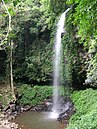
Several tracks in the park allow hikers to view the park's waterfalls and vistas to the coastal plain. A notable feature of the park is the Skywalk, an elevated walkway through and above the treetops, providing birdwatchers with an excellent view of local bird life.
Gallery
-
 Red Cedar Falls on the Rosewood Creek Track
 -
 Wonga Walk rainforest
 -
 Crystal Falls on Wonga Walk
 -
 Mushrooms on Wonga Walk
 -
 Tristania Falls on Wonga Walk
 -
 Rainforest


See also
References
- ^ a b c d "Dorrigo National Park | Learn more". NSW National Parks. Retrieved 3 April 2024.
- ^ a b c d "Dorrigo National Park". NSW National Parks. Retrieved 3 April 2024.
- ^ "The Gondwana Rainforests of Australia World Heritage Area". NSW Office of Environment & Heritage. 4 July 2016. Archived from the original on 23 June 2018.
- ^ "Dorrigo Escarpment Great Walk". NSW Environment and Heritage. 13 October 2023. Retrieved 3 April 2024.
External links
Wikimedia Commons has media related to Dorrigo National Park.
- Official website
Wikivoyage has a travel guide for Dorrigo National Park.
- v
- t
- e
National parks of New South Wales, Australia
- Abercrombie
- Breelong
- Capertee
- Conimbla
- Coolah Tops
- Drillwarrina
- Gardens of Stone
- Garrawilla
- Goobang
- Goulburn
- Kanangra-Boyd
- Lachlan Valley
- Marrangaroo
- Nangar
- Popran
- Turon
- Warrumbungle
- Weddin Mountains
- Wollemi
- Brindingabba
- Culgoa
- Gundabooka
- Kalyarr
- Kemendok
- Kinchega
- Koonaburra
- Mallee Cliffs
- Mungo
- Mutawintji
- Narriearra Caryapundy Swamp
- Paroo-Darling
- Sturt
- Toorale
- Yanga
- Barakee
- Barrington Tops
- Belford
- Ben Halls Gap
- Biriwal Bulga
- Booti Booti
- Bouddi
- Brisbane Water
- Coolah Tops
- Coorabakh
- Crawney Pass
- Crowdy Bay
- Dharug
- Gir-um-bit
- Goulburn River
- Gin-Doo-Ee
- Hunter Wetlands
- Karuah
- Middle Brother
- Mount Royal
- Myall Lakes
- Saltwater
- Scone Mountain
- Tapin Tops
- Tilligerry
- Towarri
- Tomaree
- Wallarah
- Wallingat
- Watagans
- Werakata
- Woko
- Wollemi
- Wyrrabalong
- Yengo
- Bald Rock
- Barool
- Basket Swamp
- Boonoo Boonoo
- Ben Halls Gap
- Burral Yurrul
- Butterleaf
- Capoompeta
- Carrai
- Cascade
- Cataract
- Cathedral Rock
- Coolah Tops
- Cottan-Bimbang
- Couradda
- Crawney Pass
- Cunnawarra
- Dowe
- Gibraltar Range
- Guy Fawkes River
- Indwarra
- Kings Plain
- Koreelah
- Kwiambal
- Maryland
- Mount Clunie
- Mount Kaputar
- Mount Nothofagus
- Mummel Gulf
- New England
- Nowendoc
- Nullamanna
- Nymboida
- Oxley Wild Rivers
- Single
- Timbarra
- Tooloom
- Towarri
- Warra
- Wallabadah
- Warrabah
- Washpool
- Watsons Creek
- Werrikimbe
- Arakwal
- Bago Bluff
- Bellinger River
- Bindarri
- Biriwal Bulga
- Bongil Bongil
- Border Ranges
- Broadwater
- Bundjalung
- Bungawalbin
- Carrai
- Chaelundi
- Cottan-Bimbang
- Crowdy Bay
- Dooragan
- Dorrigo
- Dunggir
- Fortis Creek
- Gibraltar Range
- Goonengerry
- Guy Fawkes River
- Hat Head
- Junuy Juluum
- Kumbatine
- Limeburners Creek
- Mallanganee
- Maria
- Mebbin
- Middle Brother
- Mooball
- Mount Jerusalem
- Mount Nothofagus
- Mount Pikapene
- New England
- Nightcap
- Nymboi-Binderay
- Nymboida
- Ramornie
- Richmond Range
- Sea Acres
- Toonumber
- Ulidarra
- Washpool
- Werrikimbe
- Willi Willi
- Wollumbin
- Yabbra
- Yarrahapinni Wetlands
- Yarriabini
- Yuraygir
- Benambra
- Brindabella
- Cocoparra
- Jimberoo
- Jindalee
- Kalyarr
- Kosciuszko
- Lachlan Valley
- Livingstone
- Minjary
- Murray Valley
- Murrumbidgee Valley
- Oolambeyan
- Willandra
- Woomargama
- Yanga
- Abercrombie
- Bangadilly
- Beowa
- Biamanga
- Blue Mountains
- Bournda
- Brindabella
- Budawang
- Budderoo
- Clyde River
- Deua
- Eurobodalla
- Gourock
- Gulaga
- Kooraban
- Kosciuszko
- Mares Forest
- Macquarie Pass
- Mimosa Rocks
- Monga
- Morton
- Mount Imlay
- Murramarang
- Nattai
- South East Forests
- Tallaganda
- Tarlo River
- Wadbilliga
- Yanununbeyan
Authority control databases | |
|---|---|
| International |
|
| National |
|


