Delhi Metropark
Park in Washtenaw County, Michigan, United States
42°19′50.51″N 83°48′29.43″W / 42.3306972°N 83.8081750°W / 42.3306972; -83.8081750Delhi Metropark is a park in the Huron-Clinton system of metro parks. It is an 81-acre (330,000 m2) park on the Huron River located five miles (8 km) northwest of Ann Arbor. It has picnic areas, two picnic shelters, swings and slides, river fishing, canoe rental and softball diamonds. A children's playground features an adventure playship, ride-on toys and swings. A Metropark daily or annual vehicle permit is required for entry to the park. The park will eventually be linked to Dexter-Huron Metropark and Hudson Mills Metropark via the Border-to-Border Trail.[1][2][3][4][5]
-
 Children's play area
 -
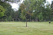 Picnic area


History
In 1835, there was a sawmill located on the Huron River at this site. That year, Norman Gooddale purchased the mill for $50 and added a flour mill to the site. Jacob Doremus platted a village adjacent to the mill in 1836 named Michigan Village, although the name was changed to Delhi shortly afterward. In 1842, Gooddale acquired all of the unsold lots. His son Frank expanded the mill, shipping flour to New England and employing 20 people; in 1880, Delhi Mills shipped 41,000 barrels of flour on the Michigan Central Railroad.[6] In 1883, Delhi had 2 flour mills, a woolen mill and a saw mill, taking power from a dam 150 feet long with a 7-foot head and producing 140 horsepower when all mills run at once.[7]
Today's Delhi Rapids is the remains of the collapsed mill dam that once powered Delhi Mills.
References
- ^ "Welcome to Pure Michigan". 10 October 2016. Archived from the original on 7 February 2011. Retrieved 18 August 2010.
- ^ "Delhi Metropark - Ann Arbor - LocalWiki".
- ^ "Delhi Metropark: Reviews & Upcoming Events - WLAJ ABC 53". Archived from the original on 2011-07-18. Retrieved 2010-08-18.
- ^ "Ann Arbor Area Convention and Visitors Bureau - Visitor's Guide - Delhi Metropark". www.visitannarbor.org. Archived from the original on 2011-07-28.
- ^ Domm, Robert W. (2006). Backroads of Michigan. ISBN 9781610603478.
- ^ Scio Township, History of Washtenaw County, Michigan, Vol 2, Charles C, Chapman, 1881; pages 828, 844, 849-853.
- ^ James L. Greenleaf, Report on the Water-Powers of the Drainage Basins of Lakes Huron and Erie, Eastern Drainage Area of the Lower Peninsula of Michigan, Huron River, Description of Developed Power, in Water Power of the United States, Part I Department of the Interior, Census Office, GPO, Washington, 1885; page 494.
External links
- Huron-Clinton Metroparks
- U.S. Geological Survey Map at the U.S. Geological Survey Map Website. Retrieved November 16th, 2022.
- v
- t
- e
Parks in metropolitan Detroit
- Belle Isle
- Campau Park
- Campus Martius
- Chandler Park
- Clark Park
- Central Park
- Dequindre Cut
- International Riverfront
- Engel Memorial Park
- Ford Park
- Fort Wayne
- Gabriel Richard Park
- Grand Circus
- Howell Park
- Lafayette Park
- Milliken State Park and Harbor
- New Center Park
- Owen Park
- Palmer Park
- Patton Park
- Reid Memorial Park
- Roosevelt Park
- River Rouge Park
- State Fairgrounds
- Three Mile Drive Park
- UIS Irish Plaza
600 to 1,500 acres (243 to 607 ha)
- Addison Oaks
- Algonac State Park
- Belle Isle
- Camp Dearborn
- Crosswinds Marsh
- Hayes State Park (Irish Hills)
- Independence Oaks
- Lower Huron
- Lakeport State Park
- Maybury State Park
- Metamora-Hadley Recreation Area
- Metro Beach Metropark
- Sterling State Park
- Clinton River
- Detroit River (Islands)
- Huron River
- Lake St. Clair
- River Rouge
- St. Clair River
- Belle Isle
- Kensington
- Lakeside Beach and Park
- Lighthouse Beach and Park
- Metro Beach
- Stony Creek
5 to 36 miles (8 to 58 km)
- Bald Mountain
- Detroit River Walk / Dequindre Cut
- Highland Recreation Lakes
- Kensington
- Lakelands Trail State Park
- Novi North Park
- Paint Creek Trail
- Poly Ann Trail
- Pontiac Lake Recreation Area
- Stony Creek Inwood Trails
- Trails in Detroit
- Waterloo-Pinckney Trail
See also Tourism in metropolitan Detroit and Huron–Clinton Metroparks
| ||
|---|---|---|
| Topics |  | |
| Detroit | ||
| Municipalities over 80,000 | ||
| Municipalities 40,000 to 80,000 | ||
| Cultural enclaves | ||
| Satellite cities | ||
| Counties in MSA | ||
| Counties in CSA | ||


 | This Washtenaw County, Michigan location article is a stub. You can help Wikipedia by expanding it. |
- v
- t
- e


