Claremont Isles National Park
Protected area in Queensland, Australia
13°54′40″S 143°50′02″E / 13.91111°S 143.83389°E / -13.91111; 143.83389Claremont Isles is a national park located in Queensland, Australia, 1783 km northwest of Brisbane. Established in 1989, the isles are managed by the Queensland Parks and Wildlife Service.
The isles constitute an important breeding and roosting habitat for a variety of birds, specially seabirds. The habitat consists of coral reefs and swaths of offshore seagrass. This makes it a unique habitat for the birds. To preserve the area, going ashore is prohibited.[1]
The elevation of the terrain is 11.7 metres.[2]
Wildlife

The isles provided habitat to a variety of birds and animals.
Birds
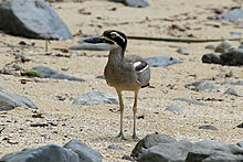
There are three islands in the Claremont Isles National Park: Fife, Pelican and Burkitt islands. All three islands have breeding populations of terns. Burkitt Island is an important breeding ground for the pied imperial pigeon. Migratory species such as the beach stone-curlew also flock to the island's extensive sand flats and lagoons. Australian terns lend the Pelican Island their name and Fife Island is famous for its population of wedge-tailed shearwaters.[3]
See also
 Queensland portal

References
- ^ "Claremont Isles National Park". The State of Queensland (Department of National Parks, Recreation, Sport and Racing). Retrieved 5 July 2013.
- ^ "Claremont Isles National Park, Location in Claremont Isles, Queensland, Australia - Aloeus". www.aloeus.com. Retrieved 26 February 2022.
- ^ "About Claremont Isles". The State of Queensland (Department of National Parks, Recreation, Sport and Racing). Retrieved 5 July 2013.
- v
- t
- e
Far North Queensland, Queensland
- Cairns
- Atherton
- Aurukun
- Babinda
- Badu Island
- Bamaga
- Burketown
- Cardwell
- Chillagoe
- Coen
- Cooktown
- Croydon
- Dimbulah
- Doomadgee
- Georgetown
- Gordonvale
- Herberton
- Hope Vale
- Innisfail
- Karumba
- Kowanyama
- Kuranda
- Laura
- Lockhart River
- Malanda
- Mapoon
- Mareeba
- Millaa Millaa
- Mission Beach
- Mornington Island
- Mossman
- Napranum
- Normanton
- Pormpuraaw
- Port Douglas
- Thursday Island
- Tully
- Weipa
- Wujal Wujal
- Yungaburra
- Aurukun
- Burke
- Cairns
- Carpentaria
- Cassowary Coast
- Cook
- Croydon
- Doomadgee
- Douglas
- Etheridge
- Hope Vale
- Kowanyama
- Lockhart River
- Mapoon
- Mareeba
- Mornington
- Napranum
- Northern Peninsula Area
- Pormpuraaw
- Tablelands
- Torres Strait Islands (not autonomous)
- Torres Strait Islands (autonomous)
- Weipa
- Wujal Wujal
- Yarrabah
- Alwal
- Annan River
- Apudthama
- Barnard Island Group
- Barron Gorge
- Blackbraes
- Bulleringa
- Cape Melville
- Chillagoe-Mungana
- Claremont Isles
- Clump Mountain
- Crater Lakes
- Daintree
- Danbulla
- Davies Creek
- Djiru
- Ella Bay
- Endeavour River
- Eubenangee Swamp
- Family Islands
- Fitzroy Island
- Flinders Group
- Frankland Group
- Forty Mile Scrub
- Great Basalt Wall
- Green Island
- Grey Peaks
- Girramay
- Girringun
- Goold Island
- Hann Tableland
- Hasties Swamp
- Hinchinbrook Island
- Hope Islands
- Howick Group
- Hull River
- Japoon
- Kalkajaka
- Kirrama
- Kuranda
- Kurrimine Beach
- Kutini-Payamu
- Lama Lama
- Lizard Island
- Ma’alpiku Island
- Macalister Range
- Malaan
- Maria Creek
- Marpa
- Michaelmas and Upolu Cays
- Millstream Falls
- Mitchell-Alice Rivers
- Mitirinchi Island
- Moresby Range
- Mount Cook
- Mount Hypipamee
- Mount Lewis
- Mount Spurgeon
- Mount Webb
- Mount Windsor
- Mowbray
- Ngalba Bulal
- Nymph Island
- Oyala Thumotang
- Palmerston Rocks
- Piper Islands
- Possession Island
- Precipice
- Raine Island
- Rinyirru
- Rocky Islets
- Russell River
- Sandbanks
- Saunders Islands
- Sir Charles Hardy Group
- Staaten River
- Starcke
- Three Islands
- Topaz Road
- Tully Gorge
- Turtle Group
- Two Islands
- Undara Volcanic
- Wooroonooran
- Wuthara Island
- Yamarrinh Wachangan Islands
- Yungaburra
 | This Queensland protected areas related article is a stub. You can help Wikipedia by expanding it. |
- v
- t
- e


