California Incline
Road in Santa Monica, California, US
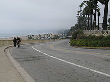 The California Incline, facing north | |
| Former name(s) | Sunset Trail |
|---|---|
| Part of | California Avenue |
| Type | Slanted road |
| Owner | City of Santa Monica |
| Maintained by | City of Santa Monica |
| Length | 1,400 ft (430 m) |
| West end |  SR 1 (Pacific Coast Highway) SR 1 (Pacific Coast Highway) |
| East end | Ocean Avenue |
| Construction | |
| Completion | 1896 |
The California Incline is a slanted road in Santa Monica, California, connecting Ocean Avenue with State Route 1 (Pacific Coast Highway or PCH). It technically is the last link, the western end of California Avenue, a major east–west street in Santa Monica.
History and overview

The California Incline was originally a walkway known as Sunset Trail, which was cut through the bluffs to provide beach access to pedestrians in 1896.[1][2] A roadway structure 1,400 feet (430 m) in length was built in 1932.[3] It is a vital street in Santa Monica, linking the PCH with Ocean Avenue and California Avenue, bisecting Palisades Park. It begins at an intersection with Ocean Avenue and California Avenue, at the top of the Palisades, extending to the PCH at the base of the bluffs.
2015–16 reconstruction
The California Incline was identified as structurally deficient in the early 1990s.[4][5] In 2007, the City of Santa Monica secured federal highway funds to replace the structure with one meeting current seismic standards.[6] The new bridge consists of a pile-supported reinforced concrete slab structure with a width of 51 feet 8 inches (15.75 m), an increase of 5 feet 8 inches (1.73 m) over the previous structure.[7][8] The project cost $17 million, with 88.5% coming from federal funds and the balance from local funds. Construction began in April 2015 and took 17 months to complete. The roadway reopened to the public on September 1, 2016. The rebuilt structure includes wider sidewalks and bicycle lanes.[6]
Popular culture
The California Incline has been featured in various films, including It's a Mad, Mad, Mad, Mad World (1963) and Knocked Up (2007). It was also featured in the hardboiled crime novel, In a Lonely Place (1942), written by Dorothy B. Hughes.[9] It was also portrayed in some video games including Street Racing Syndicate, Midnight Club II, Midnight Club: LA (and its Remix version), and Grand Theft Auto V.[10]
See also
- McClure Tunnel
References
- ^ Carcamo, Cindy (August 20, 2016). "California Incline in Santa Monica set to reopen Sept. 1". Los Angeles Times. Retrieved March 25, 2019.
- ^ Garbee, Jenn; Gottesman, Nancy; Schwartz, Margery L. (2007). Hometown Santa Monica: The Bay Cities Book. Pasadena, CA: Prospect Park. ISBN 978-0975393925. Retrieved April 14, 2013 – via Google Books.
- ^ California Department of Transportation; City of Santa Monica (October 2009). "California Incline Bridge Replacement Project" (PDF). City of Santa Monica. Retrieved April 14, 2013.
- ^ California Department of Transportation; City of Santa Monica (August 2011). "California Incline Bridge Replacement Project (Revised)" (PDF). City of Santa Monica. Retrieved April 14, 2013.
- ^ Orzeck, Kurt (September 9, 2011). "SM Has 3 'Structurally Deficient' Bridges". Santa Monica Patch. Retrieved April 14, 2013.
- ^ a b Mejia, Brittny (September 1, 2016). "California Incline in Santa Monica Reopens to Traffic After 17-Month Closure". Los Angeles Times. Retrieved September 1, 2016.
- ^ "Yearlong California Incline Closure, Construction Project Is Underway in Santa Monica". Los Angeles: KTLA. Retrieved June 11, 2015.
- ^ Rohit, Parimal M. "California Incline in Santa Monica to Close Next Fall for Reconstruction". Santa Monica Mirror. Retrieved April 14, 2013.
- ^ Hughes, Dorothy B. (1942). Weinman, Sarah (ed.). In a Lonely Place. New York: Library of America. pp. 395-398. ISBN 978-1-59853-430-6.
{{cite book}}:|work=ignored (help) - ^ "Screenshot from GTA San Andreas". Archived from the original on 2014-12-10. Retrieved 2017-06-04.
- v
- t
- e
- Alameda St.
- Alvarado St.
- Atlantic Blvd./Atlantic Ave.
- Avalon Blvd.
- Aviation Blvd.
- Azusa Ave.
- Beverly Dr.
- Beverly Glen Blvd.
- Broadway
- Cahuenga Blvd.
- Central Ave.
- Crenshaw Blvd.
- Doheny Dr.
- Fairfax Ave.
- Fair Oaks Ave.
- Figueroa St.
- Garfield Ave./Cherry Ave.
- Glendale Blvd./Brand Blvd.
- Gower St.
- Grand Ave.
- Highland Ave.
- Hill St.
- Hoover
- La Brea Ave./Hawthorne Blvd.
- La Cienega Blvd.
- Lake Ave.
- Laurel Canyon Blvd./Crescent Heights Blvd.
- Lincoln Blvd.
- Los Angeles St.
- Main St.
- Normandie Ave.
- Ocean Ave.
- Orange Grove Blvd.
- Robertson Blvd.
- Rosemead Blvd./Lakewood Blvd.
- San Fernando Rd.
- San Pedro St.
- Sawtelle Blvd.
- Sepulveda Blvd.
- Sierra Hwy.
- Sierra Madre Blvd.
- Soto St.
- Pacific Blvd./Long Beach Blvd.
- Pacific Coast Hwy.
- Vermont Ave.
- Vine St.
- Western Ave.
- Westwood Blvd.
- Wilcox Ave.
- Adams Blvd.
- Alondra Blvd.
- Angeles Crest Hwy.
- Arrow Hwy.
- Artesia Blvd.
- Bandini Blvd.
- Beverly Blvd.
- Carroll Ave.
- Carson St.
- Century Blvd.
- Colima Rd./Golden Springs Dr.
- Compton Blvd./Marine Ave.
- Culver Blvd.
- Del Amo Blvd.
- El Segundo Blvd.
- Florence Ave.
- Franklin Ave.
- Garvey Ave.
- Hollywood Blvd.
- Huntington Dr.
- Imperial Hwy.
- Jefferson Blvd.
- Lomita Blvd.
- Los Feliz Blvd.
- Manchester Ave./Firestone Blvd.
- Manhattan Beach Blvd.
- Martin Luther King Jr. Blvd.
- Melrose Ave.
- Montana Ave.
- Mulholland Dr.
- Nadeau
- Obama Blvd.
- Olympic Blvd.
- Pico Blvd.
- Rosecrans Ave.
- Santa Monica Blvd.
- Slauson Ave.
- Sunset Blvd./Cesar Chavez Ave.
- Temple St.
- Vernon Ave.
- Venice Blvd.
- Washington Blvd.
- Whittier Blvd.
- Wilshire Blvd.
- Arrow Hwy.
- Balboa Blvd.
- Burbank Blvd.
- Cahuenga Blvd.
- Coldwater Canyon Ave.
- Colorado Blvd.
- De Soto Ave.
- Devonshire St.
- Foothill Blvd.
- Glenoaks Blvd.
- Lankershim Blvd.
- Laurel Canyon Blvd.
- Magnolia Blvd.
- Mulholland Dr.
- Nordhoff St.
- Reseda Blvd.
- Riverside Dr.
- Roscoe Blvd.
- San Fernando Rd.
- Sepulveda Blvd.
- Sierra Hwy.
- Sherman Way
- Sunland Blvd./Vineland Ave.
- Topanga Canyon Blvd.
- Valley Blvd.
- Van Nuys Blvd.
- Ventura Blvd.
- Victory Blvd.
traffic circles
- Gower Gulch
- Hollywood and Vine
- Naud Junction
- SM Entertainment Square
- Sunset Junction
- Abbot Kinney Blvd.
- California Incline
- Centinela Ave./Bundy Dr.
- Pacific Coast Hwy.
- San Vicente Blvd.
- Telegraph Rd.
- Gaffey St.
- Western Ave.
- 77 Sunset Strip
- "All I Wanna Do"
- "Blue Jay Way"
- "Dead Man's Curve"
- "Down Rodeo"
- "Free Fallin'"
- "I Love L.A."
- King of the Mountain
- "LA Devotee"
- Mulholland Drive
- "Pico and Sepulveda"
- Sunset Boulevard (film, musical)
- Vine Street (+Live+ song)
All un-suffixed roads are streets unless otherwise noted.


