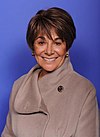
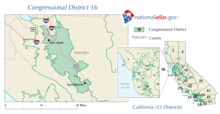
California's 16th congressional district is a congressional district in the U.S. state of California. It includes portions of Santa Clara and San Mateo counties, extending from the southwestern San Francisco Bay Area through the Santa Cruz Mountains to the Pacific coast. The district is currently represented by Democrat Anna Eshoo.
On December 20, 2021, the state redistricting commission unanimously approved a new map of congressional districts, under which the new district overlaps largely with the old 18th district.[3] The primary election of June 2022 was the first to feature the new districts; however, sitting representatives reflected the old district boundaries until the general election in November 2022.
As of the 2020 redistricting, California's 16th congressional district is located in the San Francisco Bay Area. It encompasses the west coast and interior of San Mateo County, and the western border of Santa Clara County.
San Mateo County is split between this district and the 15th district. They are partitioned by the San Francisquito Creek, Menalto Ave, Willow Rd, S Perimeter Rd, W Perimeter Rd, Bay Rd, Marsh Rd, Middlefield Rd, Highway 82, Highway 84, Alameda de las Pulgas, Woodhill Dr, Farm Hill Blvd, The Loop Rd, Jefferson Ave, Summit Way, California Way, Junipero Serra Freeway, and Highway 35. The 16th district takes in the cities of Pacifica, Menlo Park, and Half Moon Bay, California.
Santa Clara County is split between this district, the 17th district, the 18th district, and the 19th district. The 16th and 19th are partitioned by Old Santa Cruz Highway, Aldercroft Hts Rd, Weaver Rd, Soda Springs Rd, Love Harris Rd, Pheasant Creek, Guadalupe Creek, Guadalupe Mines Rd, Oak Canyon Dr, Coleman Rd, Meridian Ave, Highway G8, Guadalupe River, W Capitol Expressway, Senter Rd, Sylvandale Ave, Yerba Buena Rd, Silver Creek Rd, and E Capitol Expressway. The 16th and 18th are partitioned by Annona Ave Santiago Ave, Tully Rd, Highway 101, S King Rd, Valley Palms Apts, Story Rd, Senter Rd, E Alma Ave, S 7th St, Monterey Rd, Barnard Ave, Highway G8, Highway 87, W Alma Ave, Belmont Way, Belmont Ave, Minnesota Ave, Prevost St, Atlanta Ave, Fuller Ave, Riverside Dr, Coe Ave, Lincoln Ave, Paula St, Highway 280, and Highway 880. The 16th and 17th are partitioned by Stevens Creek Blvd, Santana Row, Olsen Dr, S Winchester Blvd, Williams Rd, Eden Ave, Lexington Dr, Valley Forge Way, Gleason Ave, Moreland Way, Payne Ave, Saratoga Ave, Doyle Rd, Highway G2, Royal Ann Dr, Wisteria Way, Rainbow Dr, Highway 85, S De Anza Blvd, Prospect Rd, Fremont Older Open Space, Permanente Creek, Highway 280, N Foothill Blvd, Homestead Rd, Stevens Creek, W EL Camino Real, Magritte Way, Highway G6, Highway 101, and Enterprise Way.
^2006 general election results Archived November 27, 2008, at the Wayback Machine
^2006 Office of the Clerk of the United States House of Representatives[permanent dead link] "Statistics of the Congressional Election of November 4, 2008" (retrieved on August 8, 2009).
^2010 Office of the Clerk of the United States House of Representatives[permanent dead link] "Statistics of the Congressional Election of November 2, 2010" (retrieved on March 24, 2011).
^2012 general election results Archived October 19, 2013, at the Wayback Machine
^U.S. House of Representatives District 16 - Districtwide Results Archived December 21, 2014, at the Wayback Machine
External links
GovTrack.us: California's 16th congressional district
RAND California Election Returns: District Definitions
 57.3 - 42.7%


 United States portal
 California portal


