Beroroha
Place in Atsimo-Andrefana, Madagascar
21°7′S 44°38′E / 21.117°S 44.633°E / -21.117; 44.633 Madagascar
611
Beroroha is a municipality in Atsimo-Andrefana Region, Madagascar. Made up of 17 villages, the commune has a total population of 17,000. The area was severely affected by the 2009 passage of Cyclone Fanele.
Beroroha lies on the Mangoky river, which is fast flowing, and can vary between 5 m and 500 m wide. The road from Ranohira (National road 15) is unpaved and only possible with 4x4 and normally takes two days from Antananarivo. An airport serves the town.
Nature
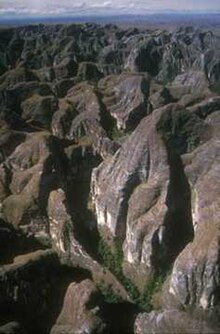
The Makay Massif lies partly in Beroroha.
References
- ^ Estimated based on DEM data from Shuttle Radar Topography Mission
21°40′43″S 45°10′23″E / 21.67861°S 45.17306°E / -21.67861; 45.17306
- v
- t
- e
Communes in the Atsimo-Andrefana Region of the Republic of MadagascarCapital: Toliara

- Ambatolahy
- Andranomafana
- Ankazoabo
- Ankeriky
- Ankilivalokely
- Ántevamena
- Berenty
- Fotivolo
- Ilemby
- Tandrano
- Ambalavato
- Ankilimary
- Benenitra
- Benonoky
- Ehara
- Ianapera
- Behisatra (Behisatsy)
- Bemavo
- Beroroha
- Fanjakana
- Mandronarivo
- Marerano
- Sakena
- Tanamary
- Tanandava
- Ambatry Mitsinjo
- Ankazomanga Ouest
- Ankazombalala
- Andranomangatsiaka
- Ankilivalo
- Antohabato
- Antsavoa
- Atsimo I
- Atsimo II
- Beantake
- Beavoha
- Belamoty
- Beora
- Besely
- Betioky
- Bezaha
- Efoetsy
- Fenoandala
- Lazarivo
- Manalobe
- Masiaboay
- Maroarivo Ankazomanga
- Montifeno
- Salobe
- Savazy II
- Sakamasay
- Soamanonga
- Soaserana
- Tameantsoa
- Tanambao Ambony
- Tongobory
- Vatolatsaka
- Vohimary
9 districts; 119 communes
 | This Atsimo-Andrefana location article is a stub. You can help Wikipedia by expanding it. |
- v
- t
- e


