Aprica
Comune in Lombardy, Italy
Aprica Abriga | |
|---|---|
Comune | |
| Comune di Aprica | |
 | |
Location of Aprica  | |
46°09′N 10°08′E / 46.150°N 10.133°E / 46.150; 10.133 | |
| Country | Italy |
| Region | Lombardy |
| Province | Sondrio (SO) |
| Government | |
| • Mayor | Dario Corvi |
| Area | |
| • Total | 20 km2 (8 sq mi) |
| Elevation | 1,180 m (3,870 ft) |
| Population (2018-01-01)[2] | |
| • Total | 1,583 |
| • Density | 79/km2 (200/sq mi) |
| Time zone | UTC+1 (CET) |
| • Summer (DST) | UTC+2 (CEST) |
| Postal code | 23031 |
| Dialing code | 0342 |
| Website | Official website |
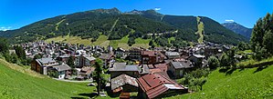
Aprica (Lombard: Abriga) is a town and comune in the province of Sondrio, Lombardy, northern Italy. It is located on the eponymous pass, the most favourable one connecting Valtellina to Val Camonica.
Its main source of income is tourism, using the areas geography to offer skiing (winter) and mountain biking (summer) opportunities.
Twin towns
 Borgo Val di Taro, Italy
- Legnano, Italy

External links
- ApricaOnLine
- Videos of skiing in Aprica
- Pictures of Aprica in winter Archived 2011-01-19 at the Wayback Machine
- v
- t
- e
- Albaredo per San Marco
- Albosaggia
- Andalo Valtellino
- Aprica
- Ardenno
- Bema
- Berbenno di Valtellina
- Bianzone
- Bormio
- Buglio in Monte
- Caiolo
- Campodolcino
- Caspoggio
- Castello dell'Acqua
- Castione Andevenno
- Cedrasco
- Cercino
- Chiavenna
- Chiesa in Valmalenco
- Chiuro
- Cino
- Civo
- Colorina
- Cosio Valtellino
- Dazio
- Delebio
- Dubino
- Faedo Valtellino
- Forcola
- Fusine
- Gerola Alta
- Gordona
- Grosio
- Grosotto
- Lanzada
- Livigno
- Lovero
- Madesimo
- Mantello
- Mazzo di Valtellina
- Mello
- Menarola
- Mese
- Montagna in Valtellina
- Morbegno
- Novate Mezzola
- Pedesina
- Piantedo
- Piateda
- Piuro
- Poggiridenti
- Ponte in Valtellina
- Postalesio
- Prata Camportaccio
- Rasura
- Rogolo
- Samolaco
- San Giacomo Filippo
- Sernio
- Sondalo
- Sondrio
- Spriana
- Talamona
- Tartano
- Teglio
- Tirano
- Torre di Santa Maria
- Tovo di Sant'Agata
- Traona
- Tresivio
- Val Masino
- Valdidentro
- Valdisotto
- Valfurva
- Verceia
- Vervio
- Villa di Chiavenna
- Villa di Tirano
Authority control databases | |
|---|---|
| International |
|
| Geographic |
|
 | This article on a location in the Province of Sondrio is a stub. You can help Wikipedia by expanding it. |
- v
- t
- e


