Amt Neuhardenberg
Amt Neuhardenberg is a former Amt ("collective municipality") in the district of Märkisch-Oderland, in Brandenburg, Germany. It was disbanded in January 2022.[1] Its seat was in Neuhardenberg.
The Amt Neuhardenberg consisted of the following municipalities:
- Gusow-Platkow
- Märkische Höhe
- Neuhardenberg
Demography
-
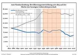 Development of Population since 1875 within the final boundaries (Blue Line: Population; Dotted Line: Comparison to Population Development of Brandenburg state; Grey Background: Time of Nazi rule; Red Background: Time of Communist rule)
 -
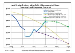 Final Population Development and Projections (Population Development before Census 2011 (blue line); Recent Population Development according to the Census in Germany in 2011 (blue bordered line); Official projections for 2005-2030 (yellow line); for 2017-2030 (scarlet line); for 2020-2030 (green line)


|
|
|
References
Authority control databases | |
|---|---|
| International |
|
| National |
|
52°35′32″N 14°16′00″E / 52.592306°N 14.266667°E / 52.592306; 14.266667
- v
- t
- e


