Aguanish River
River in Quebec, Canada
50°13′05″N 62°05′10″W / 50.2180556°N 62.0861111°W / 50.2180556; -62.0861111 • elevation
The Aguanish River, Aguanus River official name until 1985, (French: Rivière Aguanish), is a salmon river[1] that flows from north to south, emptying into the Jacques Cartier Strait,[2] the Gulf of St. Lawrence and Aguanish municipality, in Minganie RCM, Côte-Nord region, Quebec, Canada.[3][4]
Geography
The Aguanish salmon river[1] is more than 280 kilometres (170 mi) long. It is known for The Trait de Scie (Saw Cut),[5] a deep canyon 8 metres (26 ft) wide with several rapids and small waterfalls that are passed by the salmon heading up the river. The current has scoured out large cavities in the pink granite river bed, which are called "giant cooking pots".[6]
In its natural state, the Le Trait de Scie canyon[5] is classified as an impassable obstacle for Atlantic salmon. In 2016, a fish pass was built in the canyon on the Aguanus/Aguanish River.[7]
Aguanish river crosses the southwest of Aguanish municipality, it flows to its mouth in the Gulf of St. Lawrence, on the territory of almost 600 square kilometers of the municipality, in the Minganie RCM.[4] The mouth is 25 kilometres (16 mi) west of Natashquan.[6] The municipality and the Aguanish River were connected to the rest of Quebec by the extension of Route 138 in December 1996.
2021 Major Grant Expedition
In July 2021, Noah Booth and the Northern Scavenger expedition team leave for the expedition Maze to the Aguanish journey.[8] The wilds of Labrador and Quebec itinerary has been designed to follows the upper course of the Romaine and Petit-Mécatina rivers — two major rivers on the Côte-Nord currently being developed into hydroelectric complexes.[9][10]
The Aguanish River (also called the Aguanus) flows through the heart of Côte-Nord, Quebec. Starting among the sphagnum-rich bogs of the Labrador–Quebec plateau, the unassuming river quickly gains momentum as it wathefalls off the ancient Laurentian mountain range through an array of commanding canyons, magnificent drops, and glacial landforms (i.e., eskers, drumlins and kames).[8]
After the descent of the Aguanish, the 680 km journey by canoe, the expedition Royal Canadian Geographical Society-funded ended, in Aguanish municipality, the Jacques-Cartier Strait, and the Gulf of St. Lawrence. Source: Maze to the Aguanish 2021[8]
- Map, morning mist, sunny day, sunset on the river
-

-
 Dock and fishing boats
 -
 Dock and fishing boats
 -
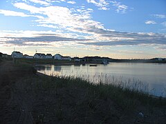
 River and Municipality
 -
 River and Municipality


Name
The name is also given as Goynish River or Aguanus River. It has been spelled Goines (17th century), Guanis, Goinis (Jacques-Nicolas Bellin map of 1744), Goynish (1776 Carver map), Agwanus, Aguanus or Agouanus (19th century maps). It probably comes from the Innu language akwanich, meaning "small shelter".[3]
"Aguanish River" name was made official on 11 April 1985.[3]
Description

The Dictionary of rivers and lakes of the province of Quebec (1914)[11] says Agwanus or Agouanus is a Montagnais word that means "where one unloads" boats.
AGWANUS, (RIVIÈRE). - Watercourse of the north coast of the St. Lawrence that forms the eastern boundary of the seigneury of Mingan. The English call it the Goynosh River. It is an excellent river for trout. A village lies on both banks of the river. The land, according to the surveyor Geo. Leclerc (1910) is fairly suitable for cultivation. Vessels drawing eight feet of water can easily enter the river. Eug, Rouillard, 1914, p.2.[11]
Some say it means "poor place" or "place with little". Another theory is it comes from the Innu word akuannis meaning a beaver scooping mud from the river bottom to build its lodge.[3]
Basin
The basin covers 5,777 square kilometres (2,231 sq mi). It lies between the basins of the Nabisipi River to the west and the Natashquan River to the east. It is partly in the unorganized territory of Lac-Jérôme, partly in the municipality of Aguanish.[12]
A map of the ecological regions of Quebec shows the river in sub-regions 6j-T and 6m-T of the east spruce/moss subdomain. Saucier, Robitaille, Grondin, Bergeron, 1998
Fauna
The river has been open to recreational fishing since 1988, the most sought after takes are:
- Salmo salar. — Saumon atlantique, Saumon ouananiche. — (Atlantic salmon, Landlocked salmon).[13]
- Salvelinus fontinalis. — Omble de Fontaine. — (Brook trout).[14]
- Esox lucius. — Grand brochet. — (Northern pike, Jackfish, Pickerel, Great northern pickerel).[15]
The Innu of Natashquan have exclusive rights to the 4 kilometres (2.5 mi) stretch from the mouth to the Trait-de-Scie. There are six salmon pools below the first falls and three above the second falls. Most catches are 3.6–5.4 kilograms (7.9–11.9 lb).[6] A 1984 study of the river identified 39 obstacles considered impassible to salmon on the river and its tributaries, with nine on the river itself from kilometre 5 upwards. The only significant amount of good habitat is upstream from kilometre 137, including the Aguanish North River.
In May 2015 the Ministry of Forests, Wildlife and Parks of Quebec announced a sport fishing catch-and-release program for large salmon on sixteen of Quebec's 111 salmon rivers.[1] These were the Mitis, Laval, Pigou, Bouleau, aux Rochers, Jupitagon, Magpie, Saint-Jean, Corneille, Piashti, Watshishou, Little Watshishou, Nabisipi, Aguanish and Natashquan rivers. The Atlantic Salmon Federation said that the measures did not go nearly far enough in protecting salmon for future generations. In view of the rapidly declining Atlantic salmon population catch-and-release should have been implemented on all rivers apart from northern Quebec.[16]
Tourism
Located 6 km from the mouth of the Aguanish River, Le Grand-Portage, approximately 1.5 km long, allows you to bypass the Le Trait de Scie canyon. A boardwalk facilitates access to the portage for visitors, salmon fishermen or hikers.[17]
To highlight the canyon site, the will of the villagers, the originality of the site, the retention of visitors and its economic contribution, combined with the significant traffic, are the main reasons considered to undertake infrastructure work welcome.[18][19][20]
Also read
References
- ^ a b c "Map of Quebec salmon rivers" (PDF) (in French). Ministry of the Environment, the Fight against Climate Change, Wildlife and Parks Quebec. 2023. Retrieved 3 September 2024.
Salmon rivers (111) – National roads – Fishing zone limit – Fishing zone subdivision – Category I and II lands
- ^ "The Explorers Jacques Cartier 1534-1542". Canadian Museum of History. Retrieved 6 September 2024.
Jacques Cartier was a sufficiently experienced navigator to be asked by Francis I to undertake the official exploration of North America. There is no doubt that he was already familiar with the sea route that he took in 1534
- ^ a b c d "Aguanish River - Toponymy". Gouvernement of Quebec (in French). Commission de Toponymy Quebec. 11 April 1985. Retrieved 3 September 2024.
One of the remarkable elements of its route is the Trait de Scie, a narrow and deep canyon into which the river rushes less than 6.5 km from its mouth.
- ^ a b "Rivière Aguanish, Aguanish River, toponymy". Gouvernement of Canada. Search the Canadian Geographical Names Database (CGNDB). 16 February 2021.
Official geographical names data are provided by the federal, provincial and territorial naming authorities of the Geographical Names Board of Canada (GNBC).
- ^ a b "Le Trait de Scie (The Saw Cut)". Gouvernement of Quebec (in French). Commission de Toponymy Quebec. Retrieved 4 September 2024.
The Aguanish River, less than 6.5 km from its mouth, rushes into a narrow and deep canyon as if a saw cut had been made in immense blocks of granite.
- ^ a b c Saumon Québec (2024). "Fishing the Aguanish River". Quebec Salmon. Retrieved 3 September 2024.
Nine pools are promised to anglers: six downstream of the first waterfall and three upstream of the second waterfall. Most of the fish caught will weigh between 3.6 and 5.4 kilograms.
- ^ "Aguanus River (Aguanish) - Habitat enhancement program Atlantic salmon from the North Shore" (PDF) (in French). 11 May 2021. p. 16. Retrieved 4 September 2024.
Atlantic salmon was retained as a species favored, because of its great ecological value and socio-economic on the North Shore.
- ^ a b c Noah Booth (2021). "With patience and persistence: Maze to the Aguanish". Royal Canadian Geographical Society. Retrieved 13 September 2024.
Today, the river is rarely traveled and has only seen a handful of documented descents in the last half-century.
- ^ "Romaine hydroelectric development" (in French). Hydro Québec. 2024. Retrieved 13 September 2024.
The complex will meet Quebec's energy needs for the next 100 years and will offer reliable, clean and renewable energy to markets outside Quebec, thus contributing to the reduction of greenhouse gases.
- ^ "Adopt the Petit Mécatina river". Fondation rivières. Retrieved 13 September 2024.
Nothing small ! it's steep mountains, falls, potholes and dizzying canyons follow one another to the rhythm of class IV and V rapids, some of which are impassable.
- ^ a b Rouillard, Eugène, 1851-1926 (1914). "Dictionary of rivers and lakes of the province of Quebec". Canadian Libraries (in French). University of Ottawa. pp. 2 of 432. Retrieved 3 September 2024.
Vessels drawing eight feet of water can enter the river quite easily. Agouanus is a Montagnais word which means "where we unload" the vessels.
{{cite web}}: CS1 maint: multiple names: authors list (link) CS1 maint: numeric names: authors list (link) - ^ Philippe Bourdon; Ghassen Ibrahim; Myriam Luce; N’Binkéna NantobBikatui; Clara Othoniel; Yohann Tremblay (April 2015). "Water master plan by Duplessis" (PDF) (in French). Duplessis Watershed Organization (OBV Duplessis). p. 97.
...the elements hydrological (surface and groundwater), anthropogenic elements (urbanization, agriculture, industry) and biological elements (aquatic and terrestrial fauna and flora).
- ^ "Saumon atlantique, Atlantic salmon". Gouvernement of Quebec (in French). Agriculture, environment and natural resources. 2024. Retrieved 5 September 2024.
Characteristic features: Atlantic salmon has an elongated body, compressed on the sides and covered with small scales.
- ^ "Omble de fontaine, Brook trout". Gouvernement of Quebec (in French). Agriculture, environment and natural resources. 204. Retrieved 5 September 2024.
It usually weighs between 100 and 1000 g, but can weigh up to 2 kg.
- ^ "Grand brochet, Northern pike" (in French). Agriculture, environment and natural resourcesg. 2024. Retrieved 5 September 2024.
Its snout is long and shaped like a duck's bill. It can weigh more than 20 kg.
- ^ Quebec salmon need stronger ... rules.
- ^ "Le Grand-Portage (The Grand Portage)". Gouvernement of Quebec (in French). Commission de Toponymy Quebec. 6 June 2024. Retrieved 8 September 2024.
The portage owes its name to its size, or to that of the canyon it allows you to bypass.
- ^ GENIVAR S.E.C (2008). "River development study – Phase 1 – Minganie RCM" (in French). Minganie RCM. p. 149. Retrieved 8 September 2024.
Aguanish River ... document the hydrographic potential of its territory, particularly in terms of recreational tourism, wildlife and energy development, thanks to general characterization of the different rivers that compose it.
- ^ "Sawcut Canyon". Tourisme Côte-Nord. Côte-Nord, between nature and excess. 2024. Retrieved 8 September 2024.
Three trails with boardwalks lead past the falls. The association also handles salmon fishing and has a guide on site. Average time: 2 to 3 hours.
- ^ "Aguanish and Île-Michon sector" (PDF) (in English and French). Côte-Nord Tourism. 25 January 2023. p. 2. Retrieved 9 September 2024.
Touristicical attractions and activities - Map
Wikimedia Commons has media related to Rivière Aguanish.
External links
- Duhaime Gérard (dir.), 2001, Historical Atlas of Quebec. The North, inhabitants and changes. Quebec, University Press, Laval - 227 p. (French)
- Isabelle Nault, 2023, Program in value of Salmon habitats Atlantic, p. 48, (French)
- Jacques Claveau, 1945, North Shore of the St. Lawrence Aguanish and Washicoutai Bay, p. 17
- Portrait préliminaire de la zone de gestion intégrée de l'eau par bassin versant Duplessis (PDF) (in French), OBV Duplessis, April 2015, retrieved 2019-10-01
- Quebec salmon need stronger preservation rules, association says, Montreal: CBC News, 10 May 2015, retrieved 2019-09-24
- Saucier, J.-P.; Robitaille, A.; Grondin, P.; Bergeron, J.-F.; Gosselin, J. (2011), The ecological regions of southern Quebec: one of the elements of the hierarchical system of ecological classification of the territory developed by the Ministry of Natural Resources (PDF). (map), 4 (in French) Ministry of Natural Resources and Wildlife, p. 8 of 13, 1998 (Download full texte PDF)
- v
- t
- e

| Municipalities | |
|---|---|
| Unorganized Territories |
- Aguanish
- Chaloupe
- Corneille
- Jupitagon
- Little Watshishou
- Magpie
- Manitou
- Mingan
- Nabisipi
- Natashquan
- Ours
- Pashashibou
- Piashti
- Quetachou
- Romaine
- Saint-Jean
- Sheldrake
- Tonnerre
- Tortue
- Véronique
- Watshishou
- Regional County Municipalities in Côte-Nord:
- Caniapiscau
- La Haute-Côte-Nord
- Le Golfe-du-Saint-Laurent
- Manicouagan
- Minganie
- Sept-Rivières
- Native reserves: Essipit
- La Romaine
- Lac-John
- Maliotenam (part of Uashat-Maliotenam)
- Matimekosh
- Mingan
- Nutashkuan
- Pessamit
- Uashat (part of Uashat-Maliotenam)
- Naskapi reserved territory: Kawawachikamach


