Čeľadice
Village and municipality in Slovakia
Municipality in Nitra Region, Slovakia
Čeľadice Család | |
|---|---|
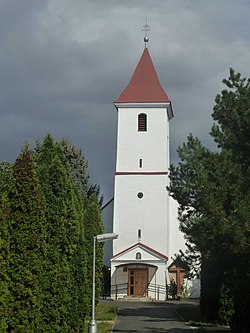 Church of Saint Catherine of Alexandria in Čeľadice | |
48°20′N 18°15′E / 48.33°N 18.25°E / 48.33; 18.25 | |
| Country |  Slovakia Slovakia |
| Region |  Nitra Region Nitra Region |
| District | Nitra District |
| First mentioned | 1113 |
| Area [1] | |
| • Total | 10.47 km2 (4.04 sq mi) |
| Elevation [2] | 180 m (590 ft) |
| Population (2021)[3] | |
| • Total | 1,075 |
| Time zone | UTC+1 (CET) |
| • Summer (DST) | UTC+2 (CEST) |
| Postal code | 951 03[2] |
| Area code | +421 37[2] |
| Car plate | NR |
| Website | www |
Čeľadice (Hungarian: Család) is a village and municipality in the Nitra District in western central Slovakia, in the Nitra Region.[4]
History
In historical records the village was first mentioned in 1113.
Geography
The village lies at an altitude of 170 metres and covers an area of 10.471 km2 (4.043 sq mi). It has a population of about 765 people.
Facilities
The village has a public library a gym and football pitch.
See also
References
- ^ "Hustota obyvateľstva - obce [om7014rr_ukaz: Rozloha (Štvorcový meter)]". www.statistics.sk (in Slovak). Statistical Office of the Slovak Republic. 2022-03-31. Retrieved 2022-03-31.
- ^ a b c "Základná charakteristika". www.statistics.sk (in Slovak). Statistical Office of the Slovak Republic. 2015-04-17. Retrieved 2022-03-31.
- ^ "Počet obyvateľov podľa pohlavia - obce (ročne)". www.statistics.sk (in Slovak). Statistical Office of the Slovak Republic. 2022-03-31. Retrieved 2022-03-31.
- ^ "Čeľadince - Okres Topoľčany - E-OBCE.sk".
Genealogical resources
The records for genealogical research are available at the state archive "Statny Archiv in Nitra, Slovakia"
- Roman Catholic church records (births/marriages/deaths): 1739-1896 (parish B)
External links
- http://www.statistics.sk/mosmis/eng/run.html
- Surnames of living people in Celadice
- v
- t
- e
Municipalities of Nitra District
- Alekšince
- Báb
- Babindol
- Bádice
- Branč
- Cabaj-Čápor
- Čab
- Čakajovce
- Čechynce
- Čeľadice
- Čifáre
- Dolné Lefantovce
- Dolné Obdokovce
- Golianovo
- Horné Lefantovce
- Hosťová
- Hruboňovo
- Ivanka pri Nitre
- Jarok
- Jelenec
- Jelšovce
- Kapince
- Klasov
- Kolíňany
- Lehota
- Lúčnica nad Žitavou
- Lukáčovce
- Lužianky
- Ľudovítová
- Malé Chyndice
- Malé Zálužie
- Malý Cetín
- Malý Lapáš
- Melek
- Mojmírovce
- Nitrianske Hrnčiarovce
- Nová Ves nad Žitavou
- Nové Sady
- Paňa
- Podhorany
- Pohranice
- Poľný Kesov
- Rišňovce
- Rumanová
- Svätoplukovo
- Štefanovičová
- Štitáre
- Šurianky
- Tajná
- Telince
- Veľká Dolina
- Veľké Chyndice
- Veľké Zálužie
- Veľký Cetín
- Veľký Lapáš
- Vinodol
- Výčapy-Opatovce
- Zbehy
- Žirany
- Žitavce

 | This Nitra Region geography article is a stub. You can help Wikipedia by expanding it. |
- v
- t
- e


