South East England
| South East England | |
|---|---|
 | |
| Geografie | |
| Fläche | 19.096 km² |
| Verwaltungssitz | Guildford |
| Demografie | |
| Bevölkerung Bevölkerungsdichte | 8.724.737 (2012)[1] 457 Einwohner/km² |
South East England (englisch für Südostengland) ist eine der neun Regionen Englands. Der Sitz der Verwaltungsbehörden ist in Guildford. Zu dieser Region gehören sechs Verwaltungsgrafschaften (Non-Metropolitan Counties)[2] und dreizehn Unitary Authorities (selbständige Stadtkreise).[2]
| Karte | Zeremonielle Grafschaft | Non-metropolitan county / Unitary Authority | Districts, Boroughs und Cities / Unitary Authority |
|---|---|---|---|
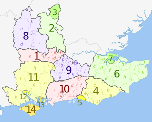 | 1. Berkshire* | a) West Berkshire U.A. | |
| b) Reading U.A. | |||
| c) Wokingham U.A. | |||
| d) Bracknell Forest U.A. | |||
| e) Windsor and Maidenhead U.A. | |||
| f) Slough U.A. | |||
| Buckinghamshire | 2. Buckinghamshire U.A. | ||
| 3. Milton Keynes U.A. | |||
| East Sussex | 4. East Sussex | a) Hastings, b) Rother, c) Wealden, d) Eastbourne, e) Lewes | |
| 5. Brighton and Hove U.A. | |||
| Kent | 6. Kent | a) Dartford, b) Gravesham, c) Sevenoaks, d) Tonbridge and Malling, e) Tunbridge Wells, f) Maidstone, g) Swale, h) Ashford, i) Folkestone and Hythe, j) Canterbury, k) Dover, l) Thanet | |
| 7. Medway U.A. | |||
| 8. Oxfordshire | a) Oxford, b) Cherwell, c) South Oxfordshire, d) Vale of White Horse, e) West Oxfordshire | ||
| 9. Surrey | a) Spelthorne, b) Runnymede, c) Surrey Heath, d) Woking, e) Elmbridge, f) Guildford, g) Waverley, h) Mole Valley, i) Epsom and Ewell, j) Reigate and Banstead, k) Tandridge | ||
| 10. West Sussex | a) Worthing, b) Arun, c) Chichester, d) Horsham, e) Crawley, f) Mid Sussex, g) Adur | ||
| Hampshire | 11. Hampshire | a) Fareham, b) Gosport, c) Winchester, d) Havant, e) East Hampshire, f) Hart, g) Rushmoor, h) Basingstoke and Deane, i) Test Valley, j) Eastleigh, k) New Forest | |
| 12. Southampton U.A. | |||
| 13. Portsmouth U.A. | |||
| 14. Isle of Wight | |||
*
Teilweise wird Berkshire zu den Non-Metropolitan Counties gerechnet. Berkshire hat keine Verwaltung auf County-Ebene und ist in sechs Unitary Authorities gegliedert, die aber keinen County-Status besitzen.
Im Vergleich mit dem BIP der EU ausgedrückt in Kaufkraftstandards erreicht die Region einen Index von 118 (EU-28=100) (2015) und ist damit nach London die wohlhabendste des Landes.[3]
Weblinks
Commons: South East England – Sammlung von Bildern, Videos und Audiodateien
Wikivoyage: South East England – Reiseführer
- Tourism South East (englisch)
- Traveline South East Journey Planner (englisch)
Einzelnachweise
- ↑ Bevölkerung von England und Wales am 30. Juni 2012 (ZIP, 832 kB)
- ↑ a b 2011 Census: Local authorities in the United Kingdom (Office for National Statistics)
- ↑ Eurostat. (PDF) Abgerufen am 22. August 2018.

Regionen Englands
London | South East England | South West England | West Midlands | North West England | North East England | Yorkshire and the Humber | East Midlands | East of England
51.316666666667-0.5Koordinaten: 51° 19′ N, 0° 30′ W


